
Cherhill
Encyclopedia
Cherhill is a village
in Wiltshire
, England
located on the A4 road between Calne
and Marlborough and about 87 miles (140 km) west of London
.
cut into the chalk hillside in 1780, the Landsdowne obelisk on the Cherhill Downs, and the crop circle
s that appeared in the fields at the bottom of the Downs. The area around the horse and obelisk is owned by the National Trust
.
 On a clear day the 840 ft (256 m) summit offers fine views, up to 25 miles (with the water tower at Tetbury in Gloucestershire visible). Atop the tall hill to the north of the village, opposite to Cherhill downs; it is said to be possible to see the Severn crossings to South Wales, 38 miles (61.2 km) to the west.
(1870-1872) says of Cherhill:
Near the village is the Lansdowne Monument
, or Cherhill Monument, a 125-foot stone obelisk
erected in 1845 by the Third Marquis of Lansdowne
in honour of his ancestor Sir William Petty
.
, Yatesbury
, Heddington
and Calstone
Wellington.
The nearest railway station is Chippenham, on the GWR line (with direct services to London Paddington & Bristol Temple Meads) 9 miles (14.5 km) to the east. The nearest motorway junction is junction 17 of the M4 north of Chippenham, 15 miles (24.1 km) away from Cherhill. The village is served by the Wigglybus scheme, which runs to Cherhill and other surrounding villages, into nearby Calne and further transport links.
parliamentary constituency and governed by Cherhill Parish Council and the Wiltshire Council
unitary authority
, which is responsible for all significant local government
functions.
In 2005 the horse was covered in black stripes to give it more of an exotic appearance, the owners of a local car franchise were attempting to make it appear more like a Panda
(although it more closely resembled a Zebra
), as a publicity stunt to help launch a new vehicle of the same name.
The top of the National Trust
owned Cherhill Downs is home to the neolithic settlement, Oldbury Hill Fort. From here it is possible to see the route of an ancient Roman road heading towards the nearby Wansdyke
trade route. The top of the hill is popular with ramblers, dog walkers and power kiters, owing to the powerful winds in action.
Village
A village is a clustered human settlement or community, larger than a hamlet with the population ranging from a few hundred to a few thousand , Though often located in rural areas, the term urban village is also applied to certain urban neighbourhoods, such as the West Village in Manhattan, New...
in Wiltshire
Wiltshire
Wiltshire is a ceremonial county in South West England. It is landlocked and borders the counties of Dorset, Somerset, Hampshire, Gloucestershire, Oxfordshire and Berkshire. It contains the unitary authority of Swindon and covers...
, England
England
England is a country that is part of the United Kingdom. It shares land borders with Scotland to the north and Wales to the west; the Irish Sea is to the north west, the Celtic Sea to the south west, with the North Sea to the east and the English Channel to the south separating it from continental...
located on the A4 road between Calne
Calne
Calne is a town in Wiltshire, southwestern England. It is situated at the northwestern extremity of the North Wessex Downs hill range, a designated Area of Outstanding Natural Beauty....
and Marlborough and about 87 miles (140 km) west of London
London
London is the capital city of :England and the :United Kingdom, the largest metropolitan area in the United Kingdom, and the largest urban zone in the European Union by most measures. Located on the River Thames, London has been a major settlement for two millennia, its history going back to its...
.
Overview
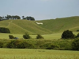
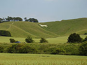
Cherhill is known for the Cherhill White HorseCherhill White Horse
The Cherhill White Horse is a hill figure on Cherhill Down, 3.5 miles east of Calne in Wiltshire, England. Dating from the late 18th century, it is the third oldest of several such white horses in Great Britain, with only the Uffington White Horse and the Westbury White Horse being older...
cut into the chalk hillside in 1780, the Landsdowne obelisk on the Cherhill Downs, and the crop circle
Crop circle
A crop circle is a sizable pattern created by the flattening of a crop such as wheat, barley, rye, maize, or rapeseed. Crop circles are also referred to as crop formations, because they are not always circular in shape. While the exact date crop circles began to appear is unknown, the documented...
s that appeared in the fields at the bottom of the Downs. The area around the horse and obelisk is owned by the National Trust
National Trust for Places of Historic Interest or Natural Beauty
The National Trust for Places of Historic Interest or Natural Beauty, usually known as the National Trust, is a conservation organisation in England, Wales and Northern Ireland...
.
History
John Marius Wilson's Imperial Gazetteer of England and WalesImperial Gazetteer of England and Wales
The Imperial Gazetteer of England and Wales is a substantial topographical dictionary first published between 1870 and 1872, edited by the Reverend John Marius Wilson. It contains a detailed description of England and Wales...
(1870-1872) says of Cherhill:
Near the village is the Lansdowne Monument
Lansdowne Monument
The Lansdowne Monument, also known as Cherhill Monument, near Cherhill in Wiltshire is a 38 metre stone obelisk erected by Third Marquis of Lansdowne to the designs of Sir Charles Barry to commemorate his ancestor, Sir William Petty in 1845....
, or Cherhill Monument, a 125-foot stone obelisk
Obelisk
An obelisk is a tall, four-sided, narrow tapering monument which ends in a pyramid-like shape at the top, and is said to resemble a petrified ray of the sun-disk. A pair of obelisks usually stood in front of a pylon...
erected in 1845 by the Third Marquis of Lansdowne
Henry Petty-FitzMaurice, 3rd Marquess of Lansdowne
Henry Petty-Fitzmaurice, 3rd Marquess of Lansdowne KG, PC, FRS , known as Lord Henry Petty from 1784 to 1809 and then as The Earl of Kerry to 1818, was a British statesman...
in honour of his ancestor Sir William Petty
William Petty
Sir William Petty FRS was an English economist, scientist and philosopher. He first became prominent serving Oliver Cromwell and Commonwealth in Ireland. He developed efficient methods to survey the land that was to be confiscated and given to Cromwell's soldiers...
.
Population and community
Cherhill has a population of around 900 people with a mixture of housing ranging from thatched cottages (some ranging back to the 14th Century) to newly built detached houses. It has a church, school, pub, village hall and cricket team. The local community spirit is typical of a close-knit village community. Cherhill parish forms part of The Oldbury Benefice together with Compton BassettCompton Bassett
Compton Bassett is a village in Wiltshire between Calne and Cherhill with a population of approximately 250. It is a largely rural village with several farms, a church, a pub and a shop.-Midge Mather Incident:...
, Yatesbury
Yatesbury
Yatesbury is a village adjacent to Cherhill, 1 mile north of the A4 road between Calne and Marlborough in Wiltshire, England. Yatesbury forms part of The Oldbury Benefice, which comprises the five parishes of Cherhill, Compton Bassett, Heddington, Calstone Wellington and Yatesbury.-RAF...
, Heddington
Heddington
Heddington is a village near to Calne in Wiltshire, forming part of The Oldbury Benefice, which comprises the 5 parishes of Cherhill, Compton Bassett, Heddington, Calstone Wellington and Yatesbury....
and Calstone
Calstone
Calstone is a settlement near Calne in Wiltshire, England, forming part of the Oldbury Benefice, which comprises the five parishes of Cherhill, Compton Bassett, Heddington, Calstone Wellington and Yatesbury.-External links:...
Wellington.
Access
Cherhill lies upon the old coaching road, the A4; which runs from central London to Bristol.The nearest railway station is Chippenham, on the GWR line (with direct services to London Paddington & Bristol Temple Meads) 9 miles (14.5 km) to the east. The nearest motorway junction is junction 17 of the M4 north of Chippenham, 15 miles (24.1 km) away from Cherhill. The village is served by the Wigglybus scheme, which runs to Cherhill and other surrounding villages, into nearby Calne and further transport links.
Governance
Cherhill is located in the Wiltshire NorthNorth Wiltshire (UK Parliament constituency)
North Wiltshire is a county constituency represented in the House of Commons of the Parliament of the United Kingdom. Until 1983, it was known as Chippenham.- Boundaries :As the name suggests, the constituency covers most of north Wiltshire...
parliamentary constituency and governed by Cherhill Parish Council and the Wiltshire Council
Wiltshire Council
Wiltshire Council is the unitary authority for most of the county of Wiltshire, in the West of England, the successor authority to Wiltshire County Council and to four districts—Kennet, North Wiltshire, Salisbury, and West Wiltshire—all of which had been created in 1973 and were...
unitary authority
Unitary authority
A unitary authority is a type of local authority that has a single tier and is responsible for all local government functions within its area or performs additional functions which elsewhere in the relevant country are usually performed by national government or a higher level of sub-national...
, which is responsible for all significant local government
Local government
Local government refers collectively to administrative authorities over areas that are smaller than a state.The term is used to contrast with offices at nation-state level, which are referred to as the central government, national government, or federal government...
functions.
The Cherhill Gang
The Cherhill Gang were a notorious group of highway men who operated in the 18th century on the London to Bath main road (A4) which passes through the village — they were noted for their robbery technique of attacking carriages of the wealthy Londoners whilst completely naked to shock the passengers into handing over their money and importantly so that they could not be identified. A painting depicting one such attack can be seen in the Black Horse pub, on the A4 main road in the village.Cherhill White Horse and Oldbury Hill Fort
The Cherhill White horse was cut out of the hillside in 1780. Due to chalk being washed away and weeds growing on it, it has been restored several times. The horse is visible from miles around, and has become a landmark synonymous with the village and local area. The most recent restoration to the delicate chalk carving took place in 2006.In 2005 the horse was covered in black stripes to give it more of an exotic appearance, the owners of a local car franchise were attempting to make it appear more like a Panda
Panda
Panda or Panda bear most often refers to:*Giant panda, an animal in the Bear familyPanda may also refer to:*Red panda, the only living member in the Ailuridae family-In biology:* Species related to the Giant panda...
(although it more closely resembled a Zebra
Zebra
Zebras are several species of African equids united by their distinctive black and white stripes. Their stripes come in different patterns unique to each individual. They are generally social animals that live in small harems to large herds...
), as a publicity stunt to help launch a new vehicle of the same name.
The top of the National Trust
National Trust for Places of Historic Interest or Natural Beauty
The National Trust for Places of Historic Interest or Natural Beauty, usually known as the National Trust, is a conservation organisation in England, Wales and Northern Ireland...
owned Cherhill Downs is home to the neolithic settlement, Oldbury Hill Fort. From here it is possible to see the route of an ancient Roman road heading towards the nearby Wansdyke
Wansdyke
Wansdyke may refer to:*Wansdyke *Wansdyke *Wansdyke...
trade route. The top of the hill is popular with ramblers, dog walkers and power kiters, owing to the powerful winds in action.