

Cherepish Ridge
Encyclopedia
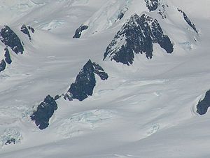
Intuition Peak
Intuition Peak is a sharp Antarctic peak of elevation 780 m in Levski Ridge, Tangra Mountains on Livingston Island in the South Shetland Islands, Antarctica. It is surmounting Iskar Glacier to the east and Devnya Valley to the west...
, in the Tangra Mountains
Tangra Mountains
Tangra Mountains form the principal mountain range of Livingston Island in the South Shetland Islands, Antarctica...
of Livingston Island in the South Shetland Islands
South Shetland Islands
The South Shetland Islands are a group of Antarctic islands, lying about north of the Antarctic Peninsula, with a total area of . By the Antarctic Treaty of 1959, the Islands' sovereignty is neither recognized nor disputed by the signatories and they are free for use by any signatory for...
, Antarctica. The ridge was named after the Cherepish Monastery in the Iskar Gorge, Western Bulgaria.
Location
The ridge is located at 62°38′24.4"S 60°02′15"Wwhich is 1.85 km north by northwest of Helmet PeakHelmet Peak, Livingston Island
Helmet Peak is a conspicuous peak rising to 1254 m in Levski Ridge, Tangra Mountains on Livingston Island in the South Shetland Islands, Antarctica just southward of the mouth of Huron Glacier. Bounded by Devnya Valley to the west, Iskar Glacier to the northeast, and Magura Glacier to the...
, 6.3 km east of Kuzman Knoll
Kuzman Knoll
Kuzman Knoll is a solitary ice-covered knoll rising to 620 m in eastern Livingston Island in the South Shetland Islands, Antarctica. The knoll forms a conspicuous landmark in Wörner Gap area, overlooking Huron Glacier and upper Perunika Glacier...
and 4.89 km southeast of Atanasoff Nunatak
Atanasoff Nunatak
Atanasoff Nunatak is a nunatak, a sharp peak rising to 523 m in the east extremity of Bowles Ridge, Livingston Island, Antarctica. The peak sumounts Huron Glacier to the south and east, and Struma Glacier to the north...
.
Bulgarian mapping in 2005 and 2009 from the Tangra 2004/05
Tangra 2004/05
The Tangra 2004/05 Expedition was commissioned by the Antarctic Place-names Commission at the Ministry of Foreign Affairs of Bulgaria, managed by the Manfred Wörner Foundation, and supported by the Bulgarian Antarctic Institute, the Institute of Mathematics and Informatics at the Bulgarian Academy...
topographic survey.
Maps
- L.L. Ivanov et al. Antarctica: Livingston Island and Greenwich Island, South Shetland Islands. Scale 1:100000 topographic map. Sofia: Antarctic Place-names Commission of Bulgaria, 2005.
- L.L. Ivanov. Antarctica: Livingston Island and Greenwich, Robert, Snow and Smith Islands. Scale 1:120000 topographic map. Troyan: Manfred Wörner Foundation, 2009. ISBN 978-954-92032-6-4