

Chef Menteur Pass
Encyclopedia
Rigolets
The Rigolets is a 12.9 kilometer long strait in Louisiana.It begins at and follows a generally eastward course to Lake Borgne, which is a lagoon in the Gulf of Mexico, where it ends at . Along with nearby Chef Menteur Pass, the Rigolets connects Lake Pontchartrain and Lake St. Catherine to Lake...
, connects Lake Pontchartrain
Lake Pontchartrain
Lake Pontchartrain is a brackish estuary located in southeastern Louisiana. It is the second-largest inland saltwater body of water in the United States, after the Great Salt Lake in Utah, and the largest lake in Louisiana. As an estuary, Pontchartrain is not a true lake.It covers an area of with...
and Lake Borgne
Lake Borgne
Lake Borgne is a lagoon in eastern Louisiana of the Gulf of Mexico. Due to coastal erosion, it is no longer actually a lake but rather an arm of the Gulf of Mexico. Its name comes from the French word borgne, which means "one-eyed".-Geography:...
in New Orleans, Louisiana
New Orleans, Louisiana
New Orleans is a major United States port and the largest city and metropolitan area in the state of Louisiana. The New Orleans metropolitan area has a population of 1,235,650 as of 2009, the 46th largest in the USA. The New Orleans – Metairie – Bogalusa combined statistical area has a population...
. It begins at 30°5′45"N 89°48′52"W and follows a generally southeastward course.
In the days of sailing ships, much commerce from the Gulf of Mexico
Gulf of Mexico
The Gulf of Mexico is a partially landlocked ocean basin largely surrounded by the North American continent and the island of Cuba. It is bounded on the northeast, north and northwest by the Gulf Coast of the United States, on the southwest and south by Mexico, and on the southeast by Cuba. In...
came through here and the Rigolets into Lake Pontchartrain to New Orleans and surrounding communities.
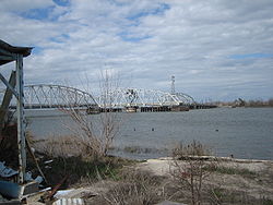
Chef Menteur Pass was long guarded by Fort Macomb
Fort Macomb
Fort Macomb is a 19th century fortress in Louisiana, on the western shore of Chef Menteur Pass. The fort is adjacent to the Venetian Isles community, now legally within the city limits of New Orleans, Louisiana, although some miles distant from the city when first built and still a considerable...
, now an abandoned ruin on the western side of the Pass. Two bridges span the Pass. The automobile bridge, constructed in 1929, carries U.S. Highway 90; the portion of this road between central New Orleans and the Pass was long known as "Chef Menteur Road" before the route became a U.S. highway, and portions are still known as "Chef Menteur Highway." The CSX railroad bridge also spans the Pass a short distance south of the highway bridge.
The Lake Catherine Neighborhood of New Orleans is to the east side of the Pass. The Venetian Isles neighborhood
Venetian Isles, New Orleans
Venetian Isles is a neighborhood of New Orleans, Louisiana. It is located on the western shore of the Chef Menteur Pass on the northern side of U.S. Highway 90....
of New Orleans is to the west of the Pass.
This area was hit hard by Hurricane Katrina
Hurricane Katrina
Hurricane Katrina of the 2005 Atlantic hurricane season was a powerful Atlantic hurricane. It is the costliest natural disaster, as well as one of the five deadliest hurricanes, in the history of the United States. Among recorded Atlantic hurricanes, it was the sixth strongest overall...
in 2005. The Highway 90 Bridge was closed from the day of the hurricane on 29 August 2005 until repairs allowed it to reopen on 11 August 2006.