

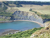
Chapmans Pool
Encyclopedia
Worth Matravers
Worth Matravers is a village and civil parish in the English county of Dorset. The village is situated on the cliffs west of Swanage. It comprises limestone cottages and farm houses and is built around a pond, which is a regular feature on postcards of the Isle of Purbeck.The civil parish stretches...
on the Isle of Purbeck
Isle of Purbeck
The Isle of Purbeck, not a true island but a peninsula, is in the county of Dorset, England. It is bordered by the English Channel to the south and east, where steep cliffs fall to the sea; and by the marshy lands of the River Frome and Poole Harbour to the north. Its western boundary is less well...
, in Dorset
Dorset
Dorset , is a county in South West England on the English Channel coast. The county town is Dorchester which is situated in the south. The Hampshire towns of Bournemouth and Christchurch joined the county with the reorganisation of local government in 1974...
, England
England
England is a country that is part of the United Kingdom. It shares land borders with Scotland to the north and Wales to the west; the Irish Sea is to the north west, the Celtic Sea to the south west, with the North Sea to the east and the English Channel to the south separating it from continental...
.
Chapman's Pool Lifeboat
In 1866, after much local pressure and because many lives were lost at sea nearby, the decision was made to build a lifeboatLifeboat (rescue)
A rescue lifeboat is a boat rescue craft which is used to attend a vessel in distress, or its survivors, to rescue crewmen and passengers. It can be hand pulled, sail powered or powered by an engine...
station at Chapman's Pool. The station was built and completed during 1867. The lifeboat George Scott was placed at Chapman's Pool in November 1866 but the station soon closed again in 1880 owing to the great expense involved in up keeping the boathouse, the land slips that constantly swept down upon it and because lacking a village nearby, and there being too few local volunteers to serve on the lifeboat. The building still stands and is used as a fishing hut.
Geology
The rocks that form the cove are the upper parts of the Kimmeridge ClayKimmeridge Clay
The Kimmeridge Clay Formation is a sedimentary deposit of fossiliferous marine clay which is of Jurassic age. It occurs in Europe.Kimmeridge Clay is arguably the most economically important unit of rocks in the whole of Europe, being the major source rock for oil fields in the North Sea hydrocarbon...
, and are rich in fossils, especially bivalves and ammonites. Most of these fossils are flattened, but three dimensional examples are preserved in the "Rotunda Nodules", including the age-marker ammonite, the coarse-ribbed Pavlovia rotunda. The Jurassic Coast
Jurassic Coast
The Jurassic Coast is a World Heritage Site on the English Channel coast of southern England. The site stretches from Orcombe Point near Exmouth in East Devon to Old Harry Rocks near Swanage in East Dorset, a distance of ....
stretches over a distance of 153 kilometres (95 mi), from Orcombe Point
Orcombe Point
Orcombe Point is a coastal feature near Exmouth, Devon, on the south coast of England. It lies about south of the city of Exeter, southeast of Exmouth town centre and about southwest of Sidmouth....
near Exmouth
Exmouth, Devon
Exmouth is a port town, civil parish and seaside resort in East Devon, England, sited on the east bank of the mouth of the River Exe. In 2001, it had a population of 32,972.-History:...
, in the west, to Old Harry Rocks
Old Harry Rocks
The Old Harry Rocks are two chalk sea stacks located at Handfast Point, on the Isle of Purbeck in Dorset, southern England.- Location :Old Harry Rocks lie directly east of Studland, about 4 kilometres northeast of Swanage, and about 10 kilometres south of the large towns of Poole and...
on the Isle of Purbeck
Isle of Purbeck
The Isle of Purbeck, not a true island but a peninsula, is in the county of Dorset, England. It is bordered by the English Channel to the south and east, where steep cliffs fall to the sea; and by the marshy lands of the River Frome and Poole Harbour to the north. Its western boundary is less well...
, in the east . The coastal exposures along the coastline provide a continuous sequence of Triassic
Triassic
The Triassic is a geologic period and system that extends from about 250 to 200 Mya . As the first period of the Mesozoic Era, the Triassic follows the Permian and is followed by the Jurassic. Both the start and end of the Triassic are marked by major extinction events...
, Jurassic
Jurassic
The Jurassic is a geologic period and system that extends from about Mya to Mya, that is, from the end of the Triassic to the beginning of the Cretaceous. The Jurassic constitutes the middle period of the Mesozoic era, also known as the age of reptiles. The start of the period is marked by...
and Cretaceous
Cretaceous
The Cretaceous , derived from the Latin "creta" , usually abbreviated K for its German translation Kreide , is a geologic period and system from circa to million years ago. In the geologic timescale, the Cretaceous follows the Jurassic period and is followed by the Paleogene period of the...
rock formations spanning approximately 185 million years of the Earths history. The localities along the Jurassic Coast includes a large range of important fossil
Fossil
Fossils are the preserved remains or traces of animals , plants, and other organisms from the remote past...
zones.
Manganese oxide findings
Manganese OxideManganese oxide
Manganese oxide is a generic term used to describe a variety of manganese oxides and hydroxides. It may refer to:* Manganese oxide, MnO* Manganese oxide, Mn3O4* Manganese oxide, Mn2O3* Manganese dioxide, , MnO2...
may also be found at the Chapmans Pool site, but does not originate from the Jurassic coast. In amongst the Kimmeridge shale and rock pools, as well as on the shore line, it is still possible to find small bubbley looking lumps of Manganese Oxide which is often mistaken as being formed from the Kimmeridge shale. However, these are the remains of part of the cargo of the Steamship
Steamboat
A steamboat or steamship, sometimes called a steamer, is a ship in which the primary method of propulsion is steam power, typically driving propellers or paddlewheels...
"Treveal" that was wrecked on the Kimmeridge Ledges below Hounstout on January 10, 1920.
Emmetts Hill Memorial
The Royal MarinesRoyal Marines
The Corps of Her Majesty's Royal Marines, commonly just referred to as the Royal Marines , are the marine corps and amphibious infantry of the United Kingdom and, along with the Royal Navy and Royal Fleet Auxiliary, form the Naval Service...
Association memorial garden at Emmetts Hill was initiated following the IRA attack on the Royal Marines Barracks Deal, home and training centre for the Royal Marines Band Service, in September 1989. The originator and organiser for the project was Colin Dishington, a member of the Dorset Branch of the RMA, since renamed the Poole and District Branch. A suitable site was chosen on an exposed headland looking out over the wild seas of Kimmerage Bay with a view down to Chapmans Pool and along the rugged Jurassic coastline to Portland. The site also overlooks a training area used by the Royal Marines both during WW2 and since, plus it fitted the beauty and tranquillity required for the memorial location. The land, which is within the boundary of the Enscombe estate, was freely given by the then owner David Scott (Lt Col retd) and right of access to the site is written into the deeds of the tenant farmer. lt was decided to add to the initial Deal inscription as it remembered Royal Marines lost in all the conflicts from 1945-1990. In 2005 a new stone was added to remember the ongoing losses of Royal Marines in current conflicts over recent years as they strive to bring peace to our troubled world. A service of dedication was conducted by the Rev W Aires with the stone unveiled by Maj Gen F C Barton CB CBE RM on 19 August 2006. Each year since the unveiling, a service has been conducted by the RMA at the memorial. The calls are sounded by a serving RM Bugler from the RM Band Service. Details of the monument are registered with the lmperial War Museum's Monument section and local guides give reference to it. Access to the site is by footpath from the car park at Renscombe Farm. The original three bar wooden rail fence has been replaced by a Purbeck stone wall to blend in with the stone walls of the area and gives better protection to the garden which is maintained by volunteers from the Poole and District RMA. As the site is on the main coastal path many people pause to reflect at the memorial or as a resting point on their walk to enjoy the views. The ashes of RMA members have also been scattered in the monument gardens and the families of those lost and resting elsewhere often visit the site, a truly peaceful and fitting memorial to the Members of the Royal Marines family who have given their lives since WW2.
See also
- List of places on the Jurassic Coast
- List of Dorset beaches
- Jurassic CoastJurassic CoastThe Jurassic Coast is a World Heritage Site on the English Channel coast of southern England. The site stretches from Orcombe Point near Exmouth in East Devon to Old Harry Rocks near Swanage in East Dorset, a distance of ....