
Cerro de San Pedro
Encyclopedia
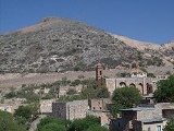
Cerro de San Pedro is a town and municipality in the Mexican
state of San Luis Potosí
. The town started as a mining town for gold and silver. It was the founding town of the state, and its figure is prominent in the state's coat of arms. , the population was 95.

and 22º 13’ north latitude
, and 2,040 meters above sea level
. The city borders Soledad de Graciano Sánchez
on the north and west, Armadillo de los Infante
on the east, and San Luis Potosí and Villa de Zaragoza
on the south. It is also known as the "Pedro's Kiss."
natives. Among them was one named Cualiname or Gualiname, who called their attention to golden outlines in their face paintings. The friar asked him where he had obtained this pigment. The native told him that there was much of the powder to the east of their present location.
Brother Diego told Brother Francisco Franco about this discovery, who told Captain Miguel Caldera
, who took possession of the place. Captain Caldera sent Gregorio de León, Juan de la Torre, and Pedro de Anda to prospect for minerals. The latter named the place San Pedro del Potosí, to honor his namesake saint and in memory of the famous mines of the Potosí in Alto Perú, today Bolivia.
In and around the hill was much gold and silver, but there was not enough water to make it worth mining. The nearest water was towards the north, in a region still dominated by several native Chichimeca tribes, and where the city of San Luis Potosí would later arise. The historian Primo Feliciano Velázquez y Basalenque included extensive descriptions of the place in his accounts.

Mexico
The United Mexican States , commonly known as Mexico , is a federal constitutional republic in North America. It is bordered on the north by the United States; on the south and west by the Pacific Ocean; on the southeast by Guatemala, Belize, and the Caribbean Sea; and on the east by the Gulf of...
state of San Luis Potosí
San Luis Potosí
San Luis Potosí officially Estado Libre y Soberano de San Luis Potosí is one of the 31 states which, with the Federal District, comprise the 32 Federal Entities of Mexico. It is divided in 58 municipalities and its capital city is San Luis Potosí....
. The town started as a mining town for gold and silver. It was the founding town of the state, and its figure is prominent in the state's coat of arms. , the population was 95.
Location
The village is located in the central part of the state. The coordinates of the city center are 100º 49’ west longitudeLongitude
Longitude is a geographic coordinate that specifies the east-west position of a point on the Earth's surface. It is an angular measurement, usually expressed in degrees, minutes and seconds, and denoted by the Greek letter lambda ....
and 22º 13’ north latitude
Latitude
In geography, the latitude of a location on the Earth is the angular distance of that location south or north of the Equator. The latitude is an angle, and is usually measured in degrees . The equator has a latitude of 0°, the North pole has a latitude of 90° north , and the South pole has a...
, and 2,040 meters above sea level
Sea level
Mean sea level is a measure of the average height of the ocean's surface ; used as a standard in reckoning land elevation...
. The city borders Soledad de Graciano Sánchez
Soledad de Graciano Sánchez
Soledad de Graciano Sánchez is the second-largest city of the state of San Luis Potosí in Mexico. It lies adjacent to the east side of the state's capital city of San Luis Potosí in the west-central part of the state. The city is the municipal seat of the municipality of the same name. The city had...
on the north and west, Armadillo de los Infante
Armadillo de los Infante
Armadillo de los Infante is a town and municipality in San Luis Potosí in central Mexico.-References:...
on the east, and San Luis Potosí and Villa de Zaragoza
Villa de Zaragoza
Villa de Zaragoza is a town and municipality in Oaxaca in south-western Mexico. The municipality covers an area of km².It is part of Cuicatlán District in the north of the Cañada Region.As of 2005, the municipality had a total population of .-References:...
on the south. It is also known as the "Pedro's Kiss."
History
In 1583, in the town of Mesquitique, Brother Diego de la Magdalena met with some of the GuachichilGuachichil
Of all the Chichimeca natives, the Guachichiles occupied the most extensive territory, stretching north to Saltillo in Coahuila and to the northern corners of Michoacán in the south...
natives. Among them was one named Cualiname or Gualiname, who called their attention to golden outlines in their face paintings. The friar asked him where he had obtained this pigment. The native told him that there was much of the powder to the east of their present location.
Brother Diego told Brother Francisco Franco about this discovery, who told Captain Miguel Caldera
Miguel Caldera
Miguel Caldera was an important figure in the pacification and colonization of Mexico's northern frontier immediately following the Spanish conquest of the Aztec Empire.-Early life:...
, who took possession of the place. Captain Caldera sent Gregorio de León, Juan de la Torre, and Pedro de Anda to prospect for minerals. The latter named the place San Pedro del Potosí, to honor his namesake saint and in memory of the famous mines of the Potosí in Alto Perú, today Bolivia.
In and around the hill was much gold and silver, but there was not enough water to make it worth mining. The nearest water was towards the north, in a region still dominated by several native Chichimeca tribes, and where the city of San Luis Potosí would later arise. The historian Primo Feliciano Velázquez y Basalenque included extensive descriptions of the place in his accounts.
Contemporary history
The mines were operated by, among other companies, Metalúrgica Mexicana, ASARCO. During its time, a mining strike was called (1948), which was lost by the miners; the company decided to leave, not before collapsing the main shafts and tunnels. The mines were never declared exhausted.Towns
This Municipality includes several towns and some colonies, as follows:- Cerro de San Pedro (Cabecera Municipal)
- Portezuelo
- Real del Potosi
- Monte De Caldera
- Cuesta de Campa
- La Zapatilla
- Divisadero
- Calderon
- Jesus Maria
- Joyita de la Cruz
- La Florida
- Granjas de San Pedro
- Granjas de la Florida
- Planta del Carmen