

Catalan chart
Encyclopedia
Catalan charts are a subtype of the medieval period (1300–1500) portolan chart
. Portolan charts are a type of map generated by using a mariner's compass and direct observation to determine the shape and location of coastlines and ports. The term "portolan" means "pertaining to ports and harbors" and should not be confused with relating to Portugal. Sometimes they are referred to as "Catalan type" portolans or simply Catalan portolans
. Two primary subgroups of medieval period portolan maps exist, the Italian, and the Catalan. While both the Italian and Catalan maps derive from the same common source (readings from a compass combined with direct observation), there are several differences, both in terms of style and in content.
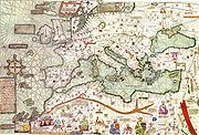 Portolan and Catalan maps all share the characteristic rhumb lines, which emanate out from compass roses located at various points on the map. These rhumb lines are generated by observation and the compass, and designate lines of bearing (though not to be confused with modern rhumb lines and meridians).
Portolan and Catalan maps are also characterized by the lack of map projection, accuracy of inland features and lines of latitude/longitude.
Additionally, there are examples of Catalan maps which show other details, such as roads or inland cities. One such example is the Catalan Atlas, one of the most important examples of Catalan work.
Portolan chart
Portolan charts are navigational maps based on realistic descriptions of harbours and coasts. They were first made in the 14th century in Italy, Portugal and Spain...
. Portolan charts are a type of map generated by using a mariner's compass and direct observation to determine the shape and location of coastlines and ports. The term "portolan" means "pertaining to ports and harbors" and should not be confused with relating to Portugal. Sometimes they are referred to as "Catalan type" portolans or simply Catalan portolans
. Two primary subgroups of medieval period portolan maps exist, the Italian, and the Catalan. While both the Italian and Catalan maps derive from the same common source (readings from a compass combined with direct observation), there are several differences, both in terms of style and in content.
Similarities between Italian and Catalan Portolans
Portolan and Catalan maps are also characterized by the lack of map projection, accuracy of inland features and lines of latitude/longitude.
Scope
The Catalan type portolans have a larger scope than the Italian maps, which generally covered the Mediterranean region and western Europe. In contrast, the Catalan type portolans extended as far north as Scandinavia and occasionally as far east as China.Content
While both maps primarily serve as navigation tools, showing the relationship between a point at sea and various harbors/coastlines, the two differ in terms of additional content. The Italian type portolan only shows coast lines, harbors and the open sea, whereas the Catalan type map also shows other information- Inland seas are shaded differently than external seas
- Seas are named
- Directions on the compass rose.
Additionally, there are examples of Catalan maps which show other details, such as roads or inland cities. One such example is the Catalan Atlas, one of the most important examples of Catalan work.
Evolution
In general, the overall "Italian" style of portolan map ceased its evolution towards the end of the 13th century, whereas the medieval Catalan map continued to evolve. There are, however, some difficulties in assessing this statement completely, as there are several Italian maps which show significant influence from the Catalan style map.Sites of Major Catalan Schools
- Majorca (Majorcan cartographic schoolMajorcan cartographic schoolThe Majorcan cartographic school is the term coined by historians to refer to the collection of cartographers, cosmographers and navigational instrument-makers that flourished in Majorca in the 14th and 15th Centuries. The label is usually inclusive of those who worked in mainland Catalonia...
) - BarcelonaBarcelonaBarcelona is the second largest city in Spain after Madrid, and the capital of Catalonia, with a population of 1,621,537 within its administrative limits on a land area of...