Carnarvon, Western Australia
Encyclopedia
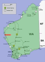
Carnarvon is a coastal town situated approximately 900 kilometres north of Perth
, Western Australia
. It lies at the mouth of the Gascoyne River
on the Indian Ocean
. The popular Shark Bay
world heritage area lies to the south of the town and the Ningaloo Reef
lies to the north. At the 2006 census
, Carnarvon had a population of 5,283.
, the town site was officially gazetted on 4 June 1891. It was named after Henry Herbert, 4th Earl of Carnarvon
, Under-Secretary of State for the Colonies
.
Carnarvon has had three tramways.
The Carnarvon Light Railway Association now operates trains along restored tracks on the jetty.
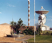
 During the 1960s, NASA
set up a tracking station
nearby to support the Gemini and Apollo
space programs. The tracking station was closed in the mid 1970s. Only the foundations of what was an historical site remain. See also OTC Satellite Earth Station Carnarvon
.
Radio Australia
had a shortwave relay station (built during the 1970s) that used to relay programming to Europe, South Asia and South East Asia.
which was built in 1906, Carnarvon Senior High School, East Carnarvon Primary School http://myweb.westnet.com.au/ecps/, Carnarvon Primary School, Carnarvon School of the Air and Carnarvon Christian School.
Korean Star ran aground in bad weather near Cape Cuvier, within the port limits of Carnarvon. Around 600 tonnes of fuel oil were spilled into the ocean. Damage was limited to 10 km of remote beaches and coastline. The ship was not salvaged and left grounded, however very little of the wreck remains to be seen.
Perth, Western Australia
Perth is the capital and largest city of the Australian state of Western Australia and the fourth most populous city in Australia. The Perth metropolitan area has an estimated population of almost 1,700,000....
, Western Australia
Western Australia
Western Australia is a state of Australia, occupying the entire western third of the Australian continent. It is bounded by the Indian Ocean to the north and west, the Great Australian Bight and Indian Ocean to the south, the Northern Territory to the north-east and South Australia to the south-east...
. It lies at the mouth of the Gascoyne River
Gascoyne River
At 760 km, the Gascoyne River is the longest river in Western Australia.The river rises below Wilgoona Hill in the Robinson Ranges west of the Gibson Desert and it flows into Shark Bay and the Indian Ocean at Carnarvon....
on the Indian Ocean
Indian Ocean
The Indian Ocean is the third largest of the world's oceanic divisions, covering approximately 20% of the water on the Earth's surface. It is bounded on the north by the Indian Subcontinent and Arabian Peninsula ; on the west by eastern Africa; on the east by Indochina, the Sunda Islands, and...
. The popular Shark Bay
Shark Bay
Shark Bay is a World Heritage listed bay in Western Australia. The term may also refer to:* the locality of Shark Bay, now known as Denham* Shark Bay Marine Park* Shark Bay , a shark exhibit at Sea World, Gold Coast, Australia* Shire of Shark Bay...
world heritage area lies to the south of the town and the Ningaloo Reef
Ningaloo Reef
Ningaloo Reef is a fringing coral reef located off the west coast of Australia, approximately 1200 km north of Perth. The reef is 260 km long and is Australia's largest fringing coral reef and the only large reef positioned very close to a landmass....
lies to the north. At the 2006 census
Census in Australia
The Australian census is administered once every five years by the Australian Bureau of Statistics. The most recent census was conducted on 9 August 2011; the next will be conducted in 2016. Prior to the introduction of regular censuses in 1961, they had also been run in 1901, 1911, 1921, 1933,...
, Carnarvon had a population of 5,283.
History
The town was founded in 1883, initially as a port and supply centre for the surrounding region, and is the administrative centre for the Shire of CarnarvonShire of Carnarvon
The Shire of Carnarvon is a Local Government Area in the Gascoyne region of Western Australia, located about north of the state capital, Perth. The Shire covers an area of , and its seat of government is the town of Carnarvon...
, the town site was officially gazetted on 4 June 1891. It was named after Henry Herbert, 4th Earl of Carnarvon
Henry Herbert, 4th Earl of Carnarvon
Henry Howard Molyneux Herbert, 4th Earl of Carnarvon, PC, DL, FSA, FRS , known as Lord Porchester from 1833 to 1849, was a British politician and a leading member of the Conservative Party...
, Under-Secretary of State for the Colonies
Under-Secretary of State for the Colonies
The Under-Secretary of State for the Colonies was a junior Ministerial post in the United Kingdom government, subordinate to the Secretary of State for the Colonies and, from 1948, also to a Minister of State....
.
Carnarvon has had three tramways.
- The first, shown on a Public Works Department map of 1884, ran from a landing site on the river, across Olivia Terrace to a shed on the other side of the road - A very short tramway indeed. The trolley used on this tramway was supposed to be hand powered, using a lever attached to crank on two of the wheels. However there is a reference to the use of wind-power.
- The second tramway, constructed between 1886 and 1887, ran west from Olivia Terrace in a straight line to the jetty, which was half way between Mangrove Point and Conspicuous Clump. It was horse drawn.
- The third, and partially remaining, tramway was completed on 9 November 1900. It runs from the townsite, across Babbage Island to the deep-sea jetty. It was constructed with a rail gauge of 2 feet (610 mm). It was 2 miles 5 chains (3.3 km) long. Due to the heavy loads of wool being carried on what was a very light railway, it was decided to convert the tramway to 3 feet 6 inches (1,067 mm) gauge in 1908–09. This tramway was worked with a steam locomotive. The tramway ceased operation in 1965.
The Carnarvon Light Railway Association now operates trains along restored tracks on the jetty.
Main industries
Main industries of the area include:- mining, at a salt mine on nearby Lake MacLeod and at inland mines.
- agriculture, particularly bananas (mainly cavendish bananaCavendish bananaThe Dwarf Cavendish banana is a banana cultivar originally from Vietnam and China. It became the primary replacement for the Gros Michel banana in the 1950s after crops of the latter were devastated by the Panama disease. The name 'Dwarf Cavendish' is in reference to the height of the pseudostem,...
s) and tomatoTomatoThe word "tomato" may refer to the plant or the edible, typically red, fruit which it bears. Originating in South America, the tomato was spread around the world following the Spanish colonization of the Americas, and its many varieties are now widely grown, often in greenhouses in cooler...
es, woolWoolWool is the textile fiber obtained from sheep and certain other animals, including cashmere from goats, mohair from goats, qiviut from muskoxen, vicuña, alpaca, camel from animals in the camel family, and angora from rabbits....
, cattle, sheep and goats. - fishing (major focus is a prawn fishery), tourism.

NASA
The National Aeronautics and Space Administration is the agency of the United States government that is responsible for the nation's civilian space program and for aeronautics and aerospace research...
set up a tracking station
Carnarvon Tracking Station
The Carnarvon Tracking Station in Western Australia was a tracking station built in 1963 for use by NASA for the Gemini program, the second step for NASA's plan to put a human on the Moon...
nearby to support the Gemini and Apollo
Project Apollo
The Apollo program was the spaceflight effort carried out by the United States' National Aeronautics and Space Administration , that landed the first humans on Earth's Moon. Conceived during the Presidency of Dwight D. Eisenhower, Apollo began in earnest after President John F...
space programs. The tracking station was closed in the mid 1970s. Only the foundations of what was an historical site remain. See also OTC Satellite Earth Station Carnarvon
OTC Satellite Earth Station Carnarvon
The OTC Satellite Earth Station Carnarvon was established to meet the need for more reliable and higher quality communications for NASA's Apollo Moon project...
.
Radio Australia
Radio Australia
Radio Australia is the international broadcasting and online service operated by the Australian Broadcasting Corporation , Australia's public broadcaster.- History :...
had a shortwave relay station (built during the 1970s) that used to relay programming to Europe, South Asia and South East Asia.
Education
There are six schools in the town; one catholic, four Western Australia Department of Education schools and one independent. These schools are: St Mary's Star of the Sea Catholic SchoolSt Mary's Star of the Sea Catholic School
St Mary's Star of the Sea Catholic School is a coeducational school for students from Kindergarten - Year 10 located in Carnarvon, Western Australia, a coastal town located 900 kilometres north of Perth ....
which was built in 1906, Carnarvon Senior High School, East Carnarvon Primary School http://myweb.westnet.com.au/ecps/, Carnarvon Primary School, Carnarvon School of the Air and Carnarvon Christian School.
Climate
Carnarvon has a warm to hot semi-arid climate. Average yearly rainfall is 226 millimetres (8.9 in) with the rainiest months (and the most reliable rainfall) being in May and June. Occasionally tropical cyclones will influence Carnarvon and bring very heavy rain, high temperatures and strong winds but apart from this erratic source of rainfall summers are otherwise dry. Temperatures range from an average maximum of 33 °C in February to 22 °C in July. Average minimums are 23 °C and 11 °C respectively.Rocketry
From 1964–1965, 12 sounding rockets were launched from Carnarvon to a maximum altitude of 120 km http://www.astronautix.com/sites/cararvon.htmKorean Star
On 20 May 1988, the bulk carrierBulk carrier
A bulk carrier, bulk freighter, or bulker is a merchant ship specially designed to transport unpackaged bulk cargo, such as grains, coal, ore, and cement in its cargo holds. Since the first specialized bulk carrier was built in 1852, economic forces have fueled the development of these ships,...
Korean Star ran aground in bad weather near Cape Cuvier, within the port limits of Carnarvon. Around 600 tonnes of fuel oil were spilled into the ocean. Damage was limited to 10 km of remote beaches and coastline. The ship was not salvaged and left grounded, however very little of the wreck remains to be seen.
External links
- Shire of Carnarvon
- Australian Places - Carnarvon
- Carnarvon Flood Photos 2010 - ABC Last accessed 22 December 2010

