

Cann Hall
Encyclopedia
Cann Hall is a ward, and former civil parish, in the London Borough of Waltham Forest
. It is north of Stratford
and Forest Gate
, east of Leyton
, and west of Wanstead Flats
, the southernmost tip of Epping Forest
.
 The Domesday Book
of 1086 lists the landowner as Hugh de Montfort, whose family took possession of a great deal of land after the Norman conquest
. His daughter Adela gave the holding to the canons of Holy Trinity, Aldgate
in 1121, and it is likely that the later name of the manor is a contraction of "Canons Hall".
The priory at Holy Trinity retained Cann Hall until the Dissolution of the Monasteries
by King Henry VIII
in 1532. The only buildings attached to the farm at that time were two old barns and a little cottage, but nevertheless several petitions were made to the crown for ownership. Bought by one Nicholas Sympson, the manor then passed through a succession of short-lived ownerships until 1671, when it was sold to William Colegrave for £2750.
 The Colegrave family continued to hold Cann Hall as a country estate in the early 19th century. Its tenants were among those whose livestock was permitted to graze on the adjacent Wanstead Flats
, which at the time belonged to The Crown
. With others they fought against the buying up of the Flats by private landowners, but in 1851-2 they lost part of the Flats in a protracted legal battle (though later much of the land was saved for the public, and is now administered by the City of London Corporation).
By the 1860s the original cottage had become an enlarged residence with ornamental gardens situated to the south of Cann Hall Road, and the buildings north of the road were known as Cann Hall Farm. None of these buildings has survived. Most of the estate was sold for development in 1880-95, though the Colegraves retained part of it until 1900.
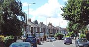
The area has become a built-up part of north-east London, consisting largely of late Victorian
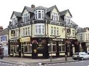
and early 20th century terraced housing. Some of the street names retain a link with the past: Colegrave Road, Selby Road, Manbey Street (all associated with the Colegrave family) - and half way along Cann Hall Road is the Colegrave Arms pub which Is now turning into a Mosque.
Cann Hall was anciently part of the parish of Wanstead. It was included in the area of the Leyton urban sanitary district. In 1894, the part of Wanstead parish in the newly-formed Leyton Urban District
was constituted a parish of its own, of 223 acre (0.90244978 km²). The population in 1901 was 22,232 and by 1951 it had dropped to 14,424. The parish was abolished in 1965.
The nearest London Underground station is Leytonstone
on the Central Line
.
Nearest railway station
London Borough of Waltham Forest
The London Borough of Waltham Forest is in northeast London, England. Officially, it forms part of Outer London as it borders Essex. However, it can be seen that the NE London boundary does not extend far compared to elsewhere in the city...
. It is north of Stratford
Stratford, London
Stratford is a place in the London Borough of Newham, England. It is located east northeast of Charing Cross and is one of the major centres identified in the London Plan. It was historically an agrarian settlement in the ancient parish of West Ham, which transformed into an industrial suburb...
and Forest Gate
Forest Gate
Forest Gate is a residential area in the London Borough of Newham, 7 miles northeast of Charing Cross. It is bordered by Manor Park to the east and and to the west lies Stratford town centre. The northern half of the busy Green Street runs through it.-History:...
, east of Leyton
Leyton
Leyton is an area of north-east London and part of the London Borough of Waltham Forest, located north east of Charing Cross. It borders Walthamstow and Leytonstone; Stratford in Newham; and Homerton and Lower Clapton in the London Borough of Hackney....
, and west of Wanstead Flats
Wanstead Flats
Wanstead Flats is the southern-most portion of Epping Forest in east London. It is surrounded by the heavily built-up areas of Leytonstone to the west, Wanstead to the north with Manor Park and Forest Gate to the southeast and south respectively. To the north-west it is connected by way of Bush...
, the southernmost tip of Epping Forest
Epping Forest
Epping Forest is an area of ancient woodland in south-east England, straddling the border between north-east Greater London and Essex. It is a former royal forest, and is managed by the City of London Corporation....
.
History
Domesday Book
Domesday Book , now held at The National Archives, Kew, Richmond upon Thames in South West London, is the record of the great survey of much of England and parts of Wales completed in 1086...
of 1086 lists the landowner as Hugh de Montfort, whose family took possession of a great deal of land after the Norman conquest
Norman conquest of England
The Norman conquest of England began on 28 September 1066 with the invasion of England by William, Duke of Normandy. William became known as William the Conqueror after his victory at the Battle of Hastings on 14 October 1066, defeating King Harold II of England...
. His daughter Adela gave the holding to the canons of Holy Trinity, Aldgate
Aldgate
Aldgate was the eastern most gateway through London Wall leading from the City of London to Whitechapel and the east end of London. Aldgate gives its name to a ward of the City...
in 1121, and it is likely that the later name of the manor is a contraction of "Canons Hall".
The priory at Holy Trinity retained Cann Hall until the Dissolution of the Monasteries
Dissolution of the Monasteries
The Dissolution of the Monasteries, sometimes referred to as the Suppression of the Monasteries, was the set of administrative and legal processes between 1536 and 1541 by which Henry VIII disbanded monasteries, priories, convents and friaries in England, Wales and Ireland; appropriated their...
by King Henry VIII
Henry VIII of England
Henry VIII was King of England from 21 April 1509 until his death. He was Lord, and later King, of Ireland, as well as continuing the nominal claim by the English monarchs to the Kingdom of France...
in 1532. The only buildings attached to the farm at that time were two old barns and a little cottage, but nevertheless several petitions were made to the crown for ownership. Bought by one Nicholas Sympson, the manor then passed through a succession of short-lived ownerships until 1671, when it was sold to William Colegrave for £2750.
Wanstead Flats
Wanstead Flats is the southern-most portion of Epping Forest in east London. It is surrounded by the heavily built-up areas of Leytonstone to the west, Wanstead to the north with Manor Park and Forest Gate to the southeast and south respectively. To the north-west it is connected by way of Bush...
, which at the time belonged to The Crown
The Crown
The Crown is a corporation sole that in the Commonwealth realms and any provincial or state sub-divisions thereof represents the legal embodiment of governance, whether executive, legislative, or judicial...
. With others they fought against the buying up of the Flats by private landowners, but in 1851-2 they lost part of the Flats in a protracted legal battle (though later much of the land was saved for the public, and is now administered by the City of London Corporation).
By the 1860s the original cottage had become an enlarged residence with ornamental gardens situated to the south of Cann Hall Road, and the buildings north of the road were known as Cann Hall Farm. None of these buildings has survived. Most of the estate was sold for development in 1880-95, though the Colegraves retained part of it until 1900.
The area has become a built-up part of north-east London, consisting largely of late Victorian
Victorian architecture
The term Victorian architecture refers collectively to several architectural styles employed predominantly during the middle and late 19th century. The period that it indicates may slightly overlap the actual reign, 20 June 1837 – 22 January 1901, of Queen Victoria. This represents the British and...
and early 20th century terraced housing. Some of the street names retain a link with the past: Colegrave Road, Selby Road, Manbey Street (all associated with the Colegrave family) - and half way along Cann Hall Road is the Colegrave Arms pub which Is now turning into a Mosque.
Cann Hall was anciently part of the parish of Wanstead. It was included in the area of the Leyton urban sanitary district. In 1894, the part of Wanstead parish in the newly-formed Leyton Urban District
Municipal Borough of Leyton
Leyton was a local government district in southwest Essex, England, from 1875 to 1965. It included the neighbourhoods of Leyton, Leytonstone and Cann Hall. It was suburban to London, forming part of the London postal district and Metropolitan Police District...
was constituted a parish of its own, of 223 acre (0.90244978 km²). The population in 1901 was 22,232 and by 1951 it had dropped to 14,424. The parish was abolished in 1965.
Politics
Approximate result in this ward for 2005 general election| Party | Votes | % | |
| Labour Party Labour Party (UK) The Labour Party is a centre-left democratic socialist party in the United Kingdom. It surpassed the Liberal Party in general elections during the early 1920s, forming minority governments under Ramsay MacDonald in 1924 and 1929-1931. The party was in a wartime coalition from 1940 to 1945, after... |
1884 | 46% | |
| Liberal Democrat Liberal Democrats The Liberal Democrats are a social liberal political party in the United Kingdom which supports constitutional and electoral reform, progressive taxation, wealth taxation, human rights laws, cultural liberalism, banking reform and civil liberties .The party was formed in 1988 by a merger of the... |
1482 | 37% | |
| Conservative Party Conservative Party (UK) The Conservative Party, formally the Conservative and Unionist Party, is a centre-right political party in the United Kingdom that adheres to the philosophies of conservatism and British unionism. It is the largest political party in the UK, and is currently the largest single party in the House... |
495 | 12% | |
| Other parties | 192 | 5% | |
| Labour majority | 402 | 9% | |
Transport and locale
Nearby places- LeytonLeytonLeyton is an area of north-east London and part of the London Borough of Waltham Forest, located north east of Charing Cross. It borders Walthamstow and Leytonstone; Stratford in Newham; and Homerton and Lower Clapton in the London Borough of Hackney....
- StratfordStratford, LondonStratford is a place in the London Borough of Newham, England. It is located east northeast of Charing Cross and is one of the major centres identified in the London Plan. It was historically an agrarian settlement in the ancient parish of West Ham, which transformed into an industrial suburb...
- MarylandMaryland, LondonMaryland is a location in east London. It forms the northeastern part of Stratford in the London Borough of Newham. The area borders Leytonstone to the north, Stratford New Town to the west and Forest Gate to the east, with the centre of Stratford to the south-west.-History:Maryland's earliest...
- Forest GateForest GateForest Gate is a residential area in the London Borough of Newham, 7 miles northeast of Charing Cross. It is bordered by Manor Park to the east and and to the west lies Stratford town centre. The northern half of the busy Green Street runs through it.-History:...
- Wanstead FlatsWanstead FlatsWanstead Flats is the southern-most portion of Epping Forest in east London. It is surrounded by the heavily built-up areas of Leytonstone to the west, Wanstead to the north with Manor Park and Forest Gate to the southeast and south respectively. To the north-west it is connected by way of Bush...
The nearest London Underground station is Leytonstone
Leytonstone tube station
Leytonstone tube station is on the Central Line of the London Underground, on the boundary of Zones 3 and 4. Towards London the next station is Leyton, while going east from Leytonstone, the line divides into two branches...
on the Central Line
Central Line
The Central line is a London Underground line, coloured red on the tube map. It is a deep-level "tube" line, running east-west across London, and, at , has the greatest total length of track of any line on the Underground. Of the 49 stations served, 20 are below ground...
.
Nearest railway station
- Maryland railway stationMaryland railway stationMaryland railway station is located in Maryland, an area of Stratford, in the London Borough of Newham in east London, England. It was originally known as Maryland Point, and is just east of Stratford station in Travelcard Zone 3, on the Great Eastern Main Line. It was first opened on 6 January...
- Forest Gate railway stationForest Gate railway stationForest Gate railway station is located in the London Borough of Newham, in east London. The station is located at It is in Travelcard Zone 3 on the Great Eastern Main Line, and was first opened in 1840, a year after the line was built, but closed in 1843, before re-opening after pressure from local...
- Leytonstone High Road railway stationLeytonstone High Road railway stationLeytonstone High Road station is a railway station in Leytonstone, London in the London Borough of Waltham Forest, on the Gospel Oak to Barking Line, between and . It has two platforms that are elevated approximately 20 feet above ground level, each of which contains a metal shelter, covered but...