

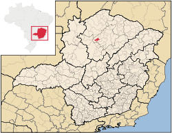
Campo Azul, Minas Gerais
Encyclopedia
Minas Gerais
Minas Gerais is one of the 26 states of Brazil, of which it is the second most populous, the third richest, and the fourth largest in area. Minas Gerais is the Brazilian state with the largest number of Presidents of Brazil, the current one, Dilma Rousseff, being one of them. The capital is the...
. In 2007 the population was 3,828 in a total area of 506 km². It became a municipality in 1995.
Campo Azul is located east of the São Francisco River
São Francisco River
The São Francisco is a river in Brazil. With a length of , it is the longest river that runs entirely in Brazilian territory, and the fourth longest in South America and overall in Brazil...
between São Francisco and Montes Claros
Montes Claros
Montes Claros is a city located in northern Minas Gerais state, in Brazil. The estimated population in 2010 was 412,284 inhabitants and the total area of the municipality was 3,470 km²...
. It is 50 km. from the nearest major population center, São Francisco, at an elevation of 612 meters. Neighboring municipalties are: Ubaí
Ubaí
Ubaí is a municipality in the north of the Brazilian state of Minas Gerais. As of 2007 the population was 11,834 in a total area of 821 km². It became a municipality in 1962.-Location:...
, Brasília de Minas
Brasília de Minas
Brasília de Minas is a Brazilian municipality located in the north of the state of Minas Gerais. In 2007 the population was 42,165 in a total area of 1,398 km². It became a municipality in 1923....
, Ponto Chique
Ponto Chique
Ponto Chique is a municipality in the north of the Brazilian state of Minas Gerais. As of 2007 the population was 4,046 in a total area of 602 km². It became a municipality in 1997.-Location:...
, and São João do Pacuí
São João do Pacuí
São João do Pacuí is a municipality in the north of the Brazilian state of Minas Gerais. As of 2007 the population was 4,003 in a total area of 420 km². It became a municipality in 1997.-Location:...
. Campo Azul is part of the statistical microregion of Montes Claros
Montes Claros
Montes Claros is a city located in northern Minas Gerais state, in Brazil. The estimated population in 2010 was 412,284 inhabitants and the total area of the municipality was 3,470 km²...
.
The most important economic activities are cattle raising and agriculture. The GDP in 2003 was R$ 8,940,000, with a per capita income of R$2,432. Campo Azul is in the bottom tier of municipalities in the state with regard to economic and social development. It suffers from isolation, poor soils, drought, and inadequate transport connections.
- Municipal Human Development IndexHuman Development IndexThe Human Development Index is a composite statistic used to rank countries by level of "human development" and separate "very high human development", "high human development", "medium human development", and "low human development" countries...
: 0.650 (2000) - State ranking: 743 out of 853 municipalities as of 2000
- National ranking: 3,780 out of 5,138 municipalities as of 2000
- Literacy rate: 74%
- Life expectancy: 67 (average of males and females)
The highest ranking municipality in Minas Gerais in 2000 was Poços de Caldas
Poços de Caldas
Poços de Caldas is a city and municipality in south-western Minas Gerais state, Brazil, in the microregion of the same name. Its estimated population in 2009 was 151,449 inhabitants...
with 0.841, while the lowest was Setubinha
Setubinha
Setubinha is a municipality in the northeast of the Brazilian state of Minas Gerais. As of 2007 the population was 10,834 in a total area of 536 km². The elevation is 729 metres. It is part of the IBGE statistical microregion of Teófilo Otoni...
with 0.568. Nationally the highest was São Caetano do Sul
São Caetano do Sul
São Caetano do Sul is a city in São Paulo state in Brazil, located in the Greater São Paulo Metropolitan Area. It is the city with the highest per capita income in Brazil and it also has the highest Human Development Index .-Geography:São Caetano do Sul is located on a plateau that is part of the...
in São Paulo with 0.919, while the lowest was Setubinha.
See also
- List of municipalities in Minas Gerais