Cabeça do Cachorro
Encyclopedia
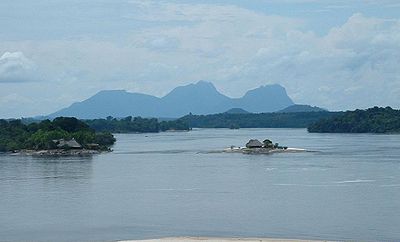
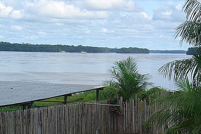
The region known as Cabeça do Cachorro (Dog‘s head) is the area comprising the northwesternmost end of the state of Amazonas, Brazil
, bordering on Colombia
and Venezuela
.
This region roughly coincides with the Brazilian municipality of São Gabriel da Cachoeira
and parts of Japurá
, and shares international borders with the Venezuela
n state of Amazonas
(to the northeast), and the Colombia
n departments of Guainía
(to north), Vaupés
(to west) and Amazonas
(to southwest). The Brazilian Army
maintains a border platoon next to the border tripoint, at the village of Cucuí
, where there is also a Brazilian Air Force
base.
Cabeça do Cachorro means, literally, "Dog's Head" in Portuguese
. The name was given after the shape of this region's map, that resembles the head of a dog with its mouth wide open. This picturesque geographical shape was defined by the Treaty of Bogotá, which was signed by Colombia and Brazil in 1907 and defined the borders between the two countries according to the uti possidetis
criterium. These borders were later confirmed by a supplementary Colombian-Brazilian treaty in 1928.
The area has several Amerindian reservations. The municipality of São Gabriel da Cachoeira, in Cabeça do Cachorro, is the first in Brazil to adopt an Amerindian language, Nheengatu
, as co-official with Portuguese.
The region also has one of the largest niobium
reserves in the world.


Brazil
Brazil , officially the Federative Republic of Brazil , is the largest country in South America. It is the world's fifth largest country, both by geographical area and by population with over 192 million people...
, bordering on Colombia
Colombia
Colombia, officially the Republic of Colombia , is a unitary constitutional republic comprising thirty-two departments. The country is located in northwestern South America, bordered to the east by Venezuela and Brazil; to the south by Ecuador and Peru; to the north by the Caribbean Sea; to the...
and Venezuela
Venezuela
Venezuela , officially called the Bolivarian Republic of Venezuela , is a tropical country on the northern coast of South America. It borders Colombia to the west, Guyana to the east, and Brazil to the south...
.
This region roughly coincides with the Brazilian municipality of São Gabriel da Cachoeira
São Gabriel da Cachoeira
São Gabriel da Cachoeira is a city and a Municipality located on the Northern shores of the Rio Negro River, in the region of Cabeça do Cachorro, Amazonas state, Brazil. Between 1952 and 1966, it was officially called Uaupés, after the nearby Vaupés River. Most of its inhabitants are indigenous...
and parts of Japurá
Japurá
Japurá is a municipality located in the Brazilian state of Amazonas. Its population was 13,026 and its area is 55,791 km². It forms the Japurá microregion together with the municipality Maraã . The southern border of both the municipality and the microregion is the Japurá River....
, and shares international borders with the Venezuela
Venezuela
Venezuela , officially called the Bolivarian Republic of Venezuela , is a tropical country on the northern coast of South America. It borders Colombia to the west, Guyana to the east, and Brazil to the south...
n state of Amazonas
Amazonas (Venezuelan state)
Amazonas State is one of the 23 states into which Venezuela is divided.The state capital is Puerto Ayacucho. The capital until the early 1900s was San Fernando de Atabapo. Although named after the Amazon River, most of the state is drained by the Orinoco. Amazonas State covers a total surface...
(to the northeast), and the Colombia
Colombia
Colombia, officially the Republic of Colombia , is a unitary constitutional republic comprising thirty-two departments. The country is located in northwestern South America, bordered to the east by Venezuela and Brazil; to the south by Ecuador and Peru; to the north by the Caribbean Sea; to the...
n departments of Guainía
Guainía Department
Guainía is a department of Colombia. It is in the east of the country, bordering Venezuela and Brazil. Its capital is Inirida. In 1963 Guainía was split off from Vaupés. The northern part and the Inírida River are included in the Orinoco river basin; the rest is part of Amazonia...
(to north), Vaupés
Vaupés Department
Vaupés is a department of Colombia in the jungle covered Amazonas Region. It is located in the southeast part of the country, bordering Brazil to the east, the department of Amazonas to the south, Caquetá and Guaviare, and Guainía to the north covering a total area of 54,135 km²...
(to west) and Amazonas
Amazonas Department
Amazonas is a department of Colombia in the south of the country. Its capital is Leticia. Its name comes from the Amazon River that drains much in the department and the rainforest that covers a large part of the department....
(to southwest). The Brazilian Army
Brazilian Army
The Brazilian Army is the land arm of the Brazilian Military. The Brazilian Army has fought in several international conflicts, mostly in South America and during the 19th century, such as the Brazilian War of Independence , Argentina-Brazil War , War of the Farrapos , Platine War , Uruguayan War ...
maintains a border platoon next to the border tripoint, at the village of Cucuí
Cucui
Cucui is a town in the Amazonas state of Brazil, on the border with the Amazonas state of Venezuela. The town is located slightly east of the Rio Negro, which flows through the Brazil–Colombia–Venezuela tripoint and forms the border between Colombia and Venezuela. The town serves as a checkpoint...
, where there is also a Brazilian Air Force
Brazilian Air Force
The Brazilian Air Force is the air branch of the Brazilian Armed Forces and one of the three national uniformed services. The FAB was formed when the Army and Navy air branch were merged into a single military force initially called "National Air Forces"...
base.
Cabeça do Cachorro means, literally, "Dog's Head" in Portuguese
Portuguese language
Portuguese is a Romance language that arose in the medieval Kingdom of Galicia, nowadays Galicia and Northern Portugal. The southern part of the Kingdom of Galicia became independent as the County of Portugal in 1095...
. The name was given after the shape of this region's map, that resembles the head of a dog with its mouth wide open. This picturesque geographical shape was defined by the Treaty of Bogotá, which was signed by Colombia and Brazil in 1907 and defined the borders between the two countries according to the uti possidetis
Uti possidetis
Uti possidetis is a principle in international law that territory and other property remains with its possessor at the end of a conflict, unless otherwise provided for by treaty; if such a treaty doesn't include conditions regarding the possession of property and territory taken during the war,...
criterium. These borders were later confirmed by a supplementary Colombian-Brazilian treaty in 1928.
The area has several Amerindian reservations. The municipality of São Gabriel da Cachoeira, in Cabeça do Cachorro, is the first in Brazil to adopt an Amerindian language, Nheengatu
Nheengatu
The Nheengatu language , often spelled Nhengatu, is an Amerindian language of a Tupi–Guarani family. It is also known by the Portuguese names língua geral da Amazônia and língua geral amazônica, both meaning "Amazonian General Language," or even by the Latin lingua brasilica...
, as co-official with Portuguese.
The region also has one of the largest niobium
Niobium
Niobium or columbium , is a chemical element with the symbol Nb and atomic number 41. It's a soft, grey, ductile transition metal, which is often found in the pyrochlore mineral, the main commercial source for niobium, and columbite...
reserves in the world.


See also
- Brazilian state of Amazonas
- Municipality of São Gabriel da CachoeiraSão Gabriel da CachoeiraSão Gabriel da Cachoeira is a city and a Municipality located on the Northern shores of the Rio Negro River, in the region of Cabeça do Cachorro, Amazonas state, Brazil. Between 1952 and 1966, it was officially called Uaupés, after the nearby Vaupés River. Most of its inhabitants are indigenous...
- Municipality of JapuráJapuráJapurá is a municipality located in the Brazilian state of Amazonas. Its population was 13,026 and its area is 55,791 km². It forms the Japurá microregion together with the municipality Maraã . The southern border of both the municipality and the microregion is the Japurá River....
- Colombia-Brazil bordersBrazil-Colombia borderThe border between Brazil and Colombia is 1644,2 km long. The boundary was delimited in two treaties:*the Vásquez Cobo-Martins treaty of 1907, establishing the line from the Rio Negro northwestward along the Amazon River-Orinoco watershed divide, "then generally southward along various river...
- Roman Catholic Diocese of São Gabriel da CachoeiraRoman Catholic Diocese of São Gabriel da CachoeiraThe Roman Catholic Diocese of São Gabriel da Cachoeira is a diocese located in the city of São Gabriel da Cachoeira in the Ecclesiastical province of Manaus in Brazil.The Bishop is Mgr Edson Taschetto Damian...

