
Burdekin River
Encyclopedia
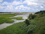
The Burdekin River in Queensland
, Australia
rises on the western slope of the Seaview Range
and flows into the Pacific Ocean
at Upstart Bay
over 200 km to the southeast of the source. The river was first encountered by Europeans during the expedition led by Ludwig Leichhardt
in 1845 and named for Mrs. Thomas Burdekin, who had provided assistance to the expedition.
Apart from the Murray River
, it is economically the most important river in Australia, and has the fourth-largest watershed of any exorheic drainage system in Australia. It is also the fourth-largest river in Australia by volume of flow, but is so erratic that its discharge can reach the mean discharge of the Yangtze
(after two severe cyclones
in 1958) or have as many as seven months with no flow whatsoever (as in 1923). This exceedingly erratic flow is due to the extreme variability of precipitation
throughout the entire basin. Annual rainfall at most gauges within the basin can range from 200mm (8 inches) to over 1,600mm (64 inches) depending on the monsoon and the number of cyclones that cross the coast. On the coast itself, the variability is even higher: at Bowen
not far from the river's mouth, the annual rainfall has ranged from 216mm in 1915 to over 2,200m in 1950.
Major tributaries
feeding the Burdekin River include the Clarke, Suttor
, Basalt
, Bowen, Belyando
and Cape rivers. The source
of the Belyando river in central western Queensland
is almost 500 km from the mouth
of the Burdekin River, and extends into the typical black-soil
grassland of Central Queensland. The Burdekin itself almost reaches the Wet Tropics in its upper reaches.
The Burdekin falls dam
, the largest dam
in Queensland
was constructed west of Ayr
and Home Hill
and completed in 1987 to form what is also known as Lake Dalrymple. In the delta
around Ayr and Home Hill, groundwater
is used extensively to irrigate
crops of sugar cane, which produce the highest quality sugar
from anywhere in Australia. This groundwater is recharged artificially during the extreme flood events that occasionally occur, usually due to a La Niña
event.
Although on paper most of the basin of the Burdekin appears perfect for rainfed crops like cotton
and maize
, in fact the rainfall is so erratic that in almost every year a would-be farmer will experience either too little or too much rain for the crop to mature properly. Thus, most of the basin of the Burdekin can be used only for low-density grazing of sheep and cattle which is less likely to be damaged economically and ecologically by the extreme risks of an extraordinarily erratic climate. The natural vegetation away from the coast is a grassland dominated by perennial Mitchell and annual Flinders grasses, whilst near the coast there are patches of dry eucalypt
forest on the typically infertile laterised
soils characteristic of most of Australia.
Queensland
Queensland is a state of Australia, occupying the north-eastern section of the mainland continent. It is bordered by the Northern Territory, South Australia and New South Wales to the west, south-west and south respectively. To the east, Queensland is bordered by the Coral Sea and Pacific Ocean...
, Australia
Australia
Australia , officially the Commonwealth of Australia, is a country in the Southern Hemisphere comprising the mainland of the Australian continent, the island of Tasmania, and numerous smaller islands in the Indian and Pacific Oceans. It is the world's sixth-largest country by total area...
rises on the western slope of the Seaview Range
Seaview Range
The Seaview Range, part of the of Great Dividing Range, is a mountain range west of Ingham in North Queensland, Australia. Much of the range is covered by rainforest and parts of it are protected in the Girringun National Park and the Wet Tropics of Queensland world heritage area.The range is the...
and flows into the Pacific Ocean
Pacific Ocean
The Pacific Ocean is the largest of the Earth's oceanic divisions. It extends from the Arctic in the north to the Southern Ocean in the south, bounded by Asia and Australia in the west, and the Americas in the east.At 165.2 million square kilometres in area, this largest division of the World...
at Upstart Bay
Upstart Bay
Upstart Bay is a bay in Queensland, Australia. It serves as the mouth of the Burdekin River.-External links:*...
over 200 km to the southeast of the source. The river was first encountered by Europeans during the expedition led by Ludwig Leichhardt
Ludwig Leichhardt
Friedrich Wilhelm Ludwig Leichhardt, known as Ludwig Leichhardt, was a Prussian explorer and naturalist, most famous for his exploration of northern and central Australia.-Early life:...
in 1845 and named for Mrs. Thomas Burdekin, who had provided assistance to the expedition.
Apart from the Murray River
Murray River
The Murray River is Australia's longest river. At in length, the Murray rises in the Australian Alps, draining the western side of Australia's highest mountains and, for most of its length, meanders across Australia's inland plains, forming the border between New South Wales and Victoria as it...
, it is economically the most important river in Australia, and has the fourth-largest watershed of any exorheic drainage system in Australia. It is also the fourth-largest river in Australia by volume of flow, but is so erratic that its discharge can reach the mean discharge of the Yangtze
Yangtze River
The Yangtze, Yangzi or Cháng Jiāng is the longest river in Asia, and the third-longest in the world. It flows for from the glaciers on the Tibetan Plateau in Qinghai eastward across southwest, central and eastern China before emptying into the East China Sea at Shanghai. It is also one of the...
(after two severe cyclones
Tropical cyclone
A tropical cyclone is a storm system characterized by a large low-pressure center and numerous thunderstorms that produce strong winds and heavy rain. Tropical cyclones strengthen when water evaporated from the ocean is released as the saturated air rises, resulting in condensation of water vapor...
in 1958) or have as many as seven months with no flow whatsoever (as in 1923). This exceedingly erratic flow is due to the extreme variability of precipitation
Precipitation (meteorology)
In meteorology, precipitation In meteorology, precipitation In meteorology, precipitation (also known as one of the classes of hydrometeors, which are atmospheric water phenomena is any product of the condensation of atmospheric water vapor that falls under gravity. The main forms of precipitation...
throughout the entire basin. Annual rainfall at most gauges within the basin can range from 200mm (8 inches) to over 1,600mm (64 inches) depending on the monsoon and the number of cyclones that cross the coast. On the coast itself, the variability is even higher: at Bowen
Bowen, Queensland
Bowen is a town on the eastern coast of Queensland, Australia. At the 2006 census, Bowen had a population of 7,484.-Geography:Bowen is located on the north-east coast of Australia, at exactly twenty degrees south of the equator. In fact, the twentieth parallel crosses the main street...
not far from the river's mouth, the annual rainfall has ranged from 216mm in 1915 to over 2,200m in 1950.
Major tributaries
Tributary
A tributary or affluent is a stream or river that flows into a main stem river or a lake. A tributary does not flow directly into a sea or ocean...
feeding the Burdekin River include the Clarke, Suttor
Suttor River
The Suttor River is a river in Central Queensland, Australia. The Belyando River is its main tributary. The river has its origins in the Leichhardt Range, north west of Glenden.A stone causeway built across the Suttor River in 1876 remains mostly intact today...
, Basalt
Basalt River (Queensland)
The Basalt River in North Queensland, Australia rises on the eastern slopes of the Great Dividing Range and flows into the Burdekin River about 60 km north of Charters Towers. The river has a length of 160 km and a catchment size of 2,900 km²....
, Bowen, Belyando
Belyando River
The Belyando River is a river in Central Queensland, Australia. The river flows in a northerly direction, flows into the Suttor River, before flowing into the Burdekin Dam and becoming a tributary of the Burdekin River...
and Cape rivers. The source
Source (river or stream)
The source or headwaters of a river or stream is the place from which the water in the river or stream originates.-Definition:There is no universally agreed upon definition for determining a stream's source...
of the Belyando river in central western Queensland
Queensland
Queensland is a state of Australia, occupying the north-eastern section of the mainland continent. It is bordered by the Northern Territory, South Australia and New South Wales to the west, south-west and south respectively. To the east, Queensland is bordered by the Coral Sea and Pacific Ocean...
is almost 500 km from the mouth
River delta
A delta is a landform that is formed at the mouth of a river where that river flows into an ocean, sea, estuary, lake, reservoir, flat arid area, or another river. Deltas are formed from the deposition of the sediment carried by the river as the flow leaves the mouth of the river...
of the Burdekin River, and extends into the typical black-soil
Vertisol
In both the FAO and USA soil taxonomy, a vertisol is a soil in which there is a high content of expansive clay known as montmorillonite that forms deep cracks in drier seasons or years. Alternate shrinking and swelling causes self-mulching, where the soil material consistently mixes itself, causing...
grassland of Central Queensland. The Burdekin itself almost reaches the Wet Tropics in its upper reaches.
The Burdekin falls dam
Burdekin Dam
Burdekin Dam is located on the Burdekin River in Queensland, Australia south west of Ayr, and Home Hill. The body of water held by the dam is also known as Lake Dalrymple. Burdekin Dam is managed by SunWater. The dam provides drinking water for twin cities of Thuringowa and Townsville and a large...
, the largest dam
Dam
A dam is a barrier that impounds water or underground streams. Dams generally serve the primary purpose of retaining water, while other structures such as floodgates or levees are used to manage or prevent water flow into specific land regions. Hydropower and pumped-storage hydroelectricity are...
in Queensland
Queensland
Queensland is a state of Australia, occupying the north-eastern section of the mainland continent. It is bordered by the Northern Territory, South Australia and New South Wales to the west, south-west and south respectively. To the east, Queensland is bordered by the Coral Sea and Pacific Ocean...
was constructed west of Ayr
Ayr, Queensland
Ayr is a town in Queensland, Australia near the delta of the Burdekin River, named after the Scottish town of Ayr by the settlers from the United Kingdom...
and Home Hill
Home Hill, Queensland
Home Hill, Queensland is a town in Queensland, Australia at the delta of the Burdekin River. It is a sugarcane growing area with underground water supplies to irrigate crops. At the 2006 census, Home Hill had a population of 2,907.- Geography :...
and completed in 1987 to form what is also known as Lake Dalrymple. In the delta
River delta
A delta is a landform that is formed at the mouth of a river where that river flows into an ocean, sea, estuary, lake, reservoir, flat arid area, or another river. Deltas are formed from the deposition of the sediment carried by the river as the flow leaves the mouth of the river...
around Ayr and Home Hill, groundwater
Groundwater
Groundwater is water located beneath the ground surface in soil pore spaces and in the fractures of rock formations. A unit of rock or an unconsolidated deposit is called an aquifer when it can yield a usable quantity of water. The depth at which soil pore spaces or fractures and voids in rock...
is used extensively to irrigate
Irrigation
Irrigation may be defined as the science of artificial application of water to the land or soil. It is used to assist in the growing of agricultural crops, maintenance of landscapes, and revegetation of disturbed soils in dry areas and during periods of inadequate rainfall...
crops of sugar cane, which produce the highest quality sugar
Sugar
Sugar is a class of edible crystalline carbohydrates, mainly sucrose, lactose, and fructose, characterized by a sweet flavor.Sucrose in its refined form primarily comes from sugar cane and sugar beet...
from anywhere in Australia. This groundwater is recharged artificially during the extreme flood events that occasionally occur, usually due to a La Niña
La Niña
La Niña is a coupled ocean-atmosphere phenomenon that is the counterpart of El Niño as part of the broader El Niño-Southern Oscillation climate pattern. During a period of La Niña, the sea surface temperature across the equatorial Eastern Central Pacific Ocean will be lower than normal by 3–5 °C...
event.
Although on paper most of the basin of the Burdekin appears perfect for rainfed crops like cotton
Cotton
Cotton is a soft, fluffy staple fiber that grows in a boll, or protective capsule, around the seeds of cotton plants of the genus Gossypium. The fiber is almost pure cellulose. The botanical purpose of cotton fiber is to aid in seed dispersal....
and maize
Maize
Maize known in many English-speaking countries as corn or mielie/mealie, is a grain domesticated by indigenous peoples in Mesoamerica in prehistoric times. The leafy stalk produces ears which contain seeds called kernels. Though technically a grain, maize kernels are used in cooking as a vegetable...
, in fact the rainfall is so erratic that in almost every year a would-be farmer will experience either too little or too much rain for the crop to mature properly. Thus, most of the basin of the Burdekin can be used only for low-density grazing of sheep and cattle which is less likely to be damaged economically and ecologically by the extreme risks of an extraordinarily erratic climate. The natural vegetation away from the coast is a grassland dominated by perennial Mitchell and annual Flinders grasses, whilst near the coast there are patches of dry eucalypt
Eucalypt
Eucalypts are woody plants belonging to three closely related genera:Eucalyptus, Corymbia and Angophora.In 1995 new evidence, largely genetic, indicated that some prominent Eucalyptus species were actually more closely related to Angophora than to the other eucalypts; they were split off into the...
forest on the typically infertile laterised
Laterite
Laterites are soil types rich in iron and aluminium, formed in hot and wet tropical areas. Nearly all laterites are rusty-red because of iron oxides. They develop by intensive and long-lasting weathering of the underlying parent rock...
soils characteristic of most of Australia.
External links
- Burdekin River in flood 1875 This photo is held by John Oxley Library, State Library of Queensland. Image number: raw00143