
Burbank, Santa Clara County, California
Encyclopedia
Burbank is a census-designated place
in Santa Clara County, California
. Part of the neighborhood has been annexed to San Jose
, while the rest consists of unincorporated areas of Santa Clara County. The population was 4,926 at the 2010 census. The neighborhood was named after Luther Burbank
.
 The historic Burbank Theatre is an area icon and currently the home of a radio station, and also is representative of the architectural significance of the Victorian, Bungalow, Deco and Craftsman style homes. With over 35 recorded significantly historical homes, many residents are restoring these small but quaint homes, making the area much more desirable — and one of the few affordable areas left in Santa Clara County to live. The Burbank Community Association along with many area businesses, residents, and home owners are working as a collective team to ensure the Burbank neighborhood continues to flourish.
The area is also a center for antique stores and is centrally located to Santana Row, Valley Fair mall, and also the downtown area.
The area is in ZIP code
95128 and area code 408
.
According to the United States Census Bureau
, the CDP has a total area of 0.4 square miles (1 km²), all of it land.
was 12,218.4 people per square mile (4,717.6/km²). The racial makeup of Burbank was 2,994 (60.8%) White, 135 (2.7%) African American, 64 (1.3%) Native American, 379 (7.7%) Asian, 16 (0.3%) Pacific Islander, 1,049 (21.3%) from other races
, and 289 (5.9%) from two or more races. Hispanic or Latino of any race were 2,509 persons (50.9%).
The Census reported that 100% of the population lived in households.
There were 1,877 households, out of which 620 (33.0%) had children under the age of 18 living in them, 688 (36.7%) were opposite-sex married couples
living together, 267 (14.2%) had a female householder with no husband present, 135 (7.2%) had a male householder with no wife present. There were 175 (9.3%) unmarried opposite-sex partnerships
, and 40 (2.1%) same-sex married couples or partnerships. 562 households (29.9%) were made up of individuals and 92 (4.9%) had someone living alone who was 65 years of age or older. The average household size was 2.62. There were 1,090 families
(58.1% of all households); the average family size was 3.32.
The population was spread out with 1,125 people (22.8%) under the age of 18, 485 people (9.8%) aged 18 to 24, 1,737 people (35.3%) aged 25 to 44, 1,273 people (25.8%) aged 45 to 64, and 306 people (6.2%) who were 65 years of age or older. The median age was 34.5 years. For every 100 females there were 100.9 males. For every 100 females age 18 and over, there were 100.9 males.
There were 1,982 housing units at an average density of 4,916.1 per square mile (1,898.1/km²), of which 823 (43.8%) were owner-occupied, and 1,054 (56.2%) were occupied by renters. The homeowner vacancy rate was 2.0%; the rental vacancy rate was 3.3%. 2,194 people (44.5% of the population) lived in owner-occupied housing units and 2,732 people (55.5%) lived in rental housing units.
of 2000, there were 5,239 people, 2,027 households, and 1,141 families residing in the CDP. The population density
was 11,748.6 people per square mile (4,495.1/km²). There were 2,063 housing units at an average density of 4,626.4/sq mi (1,770.1/km²). The racial makeup of the CDP was 63.52% White, 2.94% African American, 0.84% Native American, 6.74% Asian, 0.57% Pacific Islander, 19.81% from other races
, and 5.57% from two or more races. Hispanic or Latino of any race were 43.12% of the population.
There were 2,027 households out of which 29.6% had children under the age of 18 living with them, 36.9% were married couples
living together, 12.6% had a female householder with no husband present, and 43.7% were non-families. 32.7% of all households were made up of individuals and 6.4% had someone living alone who was 65 years of age or older. The average household size was 2.58 and the average family size was 3.32.
In the CDP the population was spread out with 24.8% under the age of 18, 8.8% from 18 to 24, 39.7% from 25 to 44, 19.4% from 45 to 64, and 7.3% who were 65 years of age or older. The median age was 33 years. For every 100 females there were 102.6 males. For every 100 females age 18 and over, there were 100.2 males.
The median income for a household in the CDP was $47,226, and the median income for a family was $51,769. Males had a median income of $43,672 versus $32,431 for females. The per capita income
for the CDP was $23,232. About 7.2% of families and 10.8% of the population were below the poverty line, including 11.5% of those under age 18 and 4.9% of those age 65 or over.
. The area is entirely surrounded by the City of San Jose
. The U.S. Geological Survey shows the area's name as official on the San Jose West, California 7.5-minute Quadrangle and it has been assigned a feature ID of 277480 in the National Geographic Names Database. Official NAD27 coordinates are given as 37°19′24"N 121°55′50"W. It is an areal feature occupying some of the area between I280 and San Carlos Street extending east almost to Meridian Avenue and west almost to SR17. The area of this district is an irregular shape. Some parcels considered inside the district, including the Luther Burbank Elementary School, 4 Wabash Avenue, lie outside this boundary. The area was named for Luther Burbank
.
Board of Supervisors
by Ken Yeager
.
In the state legislature
Burbank is located in the 13th Senate district
, represented by Democrat
Elaine Alquist
, and in the 24th Assembly district
, represented by Democrat Jim Beall.
Federally, Burbank is located in California's 16th congressional district
, which has a Cook PVI
of D +16 and is represented by Democrat Zoe Lofgren
.
(LBSD). Founded in 1906, the District celebrated its centennial in 2006. Burbank-area students attend high schools in the Campbell Union High School District
.
Sewer services are provided to other unincorporated areas of the Burbank Community by the West Valley Sanitation District, an independent sanitation district that also services neighboring cites and unincorporated areas. Waste collection in the other areas are the jurisdiction of the County of Santa Clara. Sewage treatment is provided by the San Jose/Santa Clara Water Pollution Control Plant a joint powers agency of which both districts are members.
The second Burbank fire station, sold in the late 1970s, is on the northeast corner of Scott Street and Flagg Avenue. The unusually-high garage door is the only clue today that the residence was once a fire station. The fire district became part of Santa Clara County Fire Department, (a.k.a. Central Fire District,) about 1960 and is served by San Jose Fire under a contract.
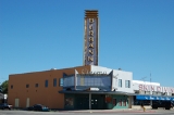
The Burbank Cinema movie theater is another local landmark supporting use of the name. It is no longer a working theater. Attached to the theater and on the right out of frame is Stan's Skin Diving Shop, another long-time landmark.
The Burbank Business Circle is the name of an undedicated roadway in the shopping center on the southwest corner of Bascom Avenue and San Carlos Street. The shopping center houses Savers' Thrift Store, Bank of the West, and long-time landmark Time Delicatessen.
The Burbank Lions Club on Bascom Avenue is a local community service organization. Many businesses have come and gone with the Burbank name, but the Burbank Pet Hospital and the Burbank Press continue service on West San Carlos Street.
Census-designated place
A census-designated place is a concentration of population identified by the United States Census Bureau for statistical purposes. CDPs are delineated for each decennial census as the statistical counterparts of incorporated places such as cities, towns and villages...
in Santa Clara County, California
Santa Clara County, California
Santa Clara County is a county located at the southern end of the San Francisco Bay Area in the U.S. state of California. As of 2010 it had a population of 1,781,642. The county seat is San Jose. The highly urbanized Santa Clara Valley within Santa Clara County is also known as Silicon Valley...
. Part of the neighborhood has been annexed to San Jose
San Jose, California
San Jose is the third-largest city in California, the tenth-largest in the U.S., and the county seat of Santa Clara County which is located at the southern end of San Francisco Bay...
, while the rest consists of unincorporated areas of Santa Clara County. The population was 4,926 at the 2010 census. The neighborhood was named after Luther Burbank
Luther Burbank
Luther Burbank was an American botanist, horticulturist and a pioneer in agricultural science.He developed more than 800 strains and varieties of plants over his 54-year career. Burbank's varied creations included fruits, flowers, grains, grasses, and vegetables...
.
The area is also a center for antique stores and is centrally located to Santana Row, Valley Fair mall, and also the downtown area.
The area is in ZIP code
ZIP Code
ZIP codes are a system of postal codes used by the United States Postal Service since 1963. The term ZIP, an acronym for Zone Improvement Plan, is properly written in capital letters and was chosen to suggest that the mail travels more efficiently, and therefore more quickly, when senders use the...
95128 and area code 408
Area code 408
North American area code 408 is a telephone area code in California that covers most of Santa Clara County and includes Gilroy, Morgan Hill, Saratoga, Los Gatos, Monte Sereno, Milpitas, Sunnyvale, Santa Clara, Cupertino, and San Jose. It was created in a 1959 split from area code 415 in a flash-cut...
.
Geography
Burbank is located at 37°19′14"N 121°55′54"W (37.320521, -121.931591).According to the United States Census Bureau
United States Census Bureau
The United States Census Bureau is the government agency that is responsible for the United States Census. It also gathers other national demographic and economic data...
, the CDP has a total area of 0.4 square miles (1 km²), all of it land.
2010
The 2010 United States Census reported that Burbank had a population of 4,926. The population densityPopulation density
Population density is a measurement of population per unit area or unit volume. It is frequently applied to living organisms, and particularly to humans...
was 12,218.4 people per square mile (4,717.6/km²). The racial makeup of Burbank was 2,994 (60.8%) White, 135 (2.7%) African American, 64 (1.3%) Native American, 379 (7.7%) Asian, 16 (0.3%) Pacific Islander, 1,049 (21.3%) from other races
Race (United States Census)
Race and ethnicity in the United States Census, as defined by the Federal Office of Management and Budget and the United States Census Bureau, are self-identification data items in which residents choose the race or races with which they most closely identify, and indicate whether or not they are...
, and 289 (5.9%) from two or more races. Hispanic or Latino of any race were 2,509 persons (50.9%).
The Census reported that 100% of the population lived in households.
There were 1,877 households, out of which 620 (33.0%) had children under the age of 18 living in them, 688 (36.7%) were opposite-sex married couples
Marriage
Marriage is a social union or legal contract between people that creates kinship. It is an institution in which interpersonal relationships, usually intimate and sexual, are acknowledged in a variety of ways, depending on the culture or subculture in which it is found...
living together, 267 (14.2%) had a female householder with no husband present, 135 (7.2%) had a male householder with no wife present. There were 175 (9.3%) unmarried opposite-sex partnerships
POSSLQ
POSSLQ is an abbreviation for "Persons of Opposite Sex Sharing Living Quarters," a term coined in the late 1970s by the United States Census Bureau as part of an effort to more accurately gauge the prevalence of cohabitation in American households....
, and 40 (2.1%) same-sex married couples or partnerships. 562 households (29.9%) were made up of individuals and 92 (4.9%) had someone living alone who was 65 years of age or older. The average household size was 2.62. There were 1,090 families
Family (U.S. Census)
A family or family household is defined by the United States Census Bureau for statistical purposes as "a householder and one or more other people related to the householder by birth, marriage, or adoption. They do not include same-sex married couples even if the marriage was performed in a state...
(58.1% of all households); the average family size was 3.32.
The population was spread out with 1,125 people (22.8%) under the age of 18, 485 people (9.8%) aged 18 to 24, 1,737 people (35.3%) aged 25 to 44, 1,273 people (25.8%) aged 45 to 64, and 306 people (6.2%) who were 65 years of age or older. The median age was 34.5 years. For every 100 females there were 100.9 males. For every 100 females age 18 and over, there were 100.9 males.
There were 1,982 housing units at an average density of 4,916.1 per square mile (1,898.1/km²), of which 823 (43.8%) were owner-occupied, and 1,054 (56.2%) were occupied by renters. The homeowner vacancy rate was 2.0%; the rental vacancy rate was 3.3%. 2,194 people (44.5% of the population) lived in owner-occupied housing units and 2,732 people (55.5%) lived in rental housing units.
2000
As of the censusCensus
A census is the procedure of systematically acquiring and recording information about the members of a given population. It is a regularly occurring and official count of a particular population. The term is used mostly in connection with national population and housing censuses; other common...
of 2000, there were 5,239 people, 2,027 households, and 1,141 families residing in the CDP. The population density
Population density
Population density is a measurement of population per unit area or unit volume. It is frequently applied to living organisms, and particularly to humans...
was 11,748.6 people per square mile (4,495.1/km²). There were 2,063 housing units at an average density of 4,626.4/sq mi (1,770.1/km²). The racial makeup of the CDP was 63.52% White, 2.94% African American, 0.84% Native American, 6.74% Asian, 0.57% Pacific Islander, 19.81% from other races
Race (United States Census)
Race and ethnicity in the United States Census, as defined by the Federal Office of Management and Budget and the United States Census Bureau, are self-identification data items in which residents choose the race or races with which they most closely identify, and indicate whether or not they are...
, and 5.57% from two or more races. Hispanic or Latino of any race were 43.12% of the population.
There were 2,027 households out of which 29.6% had children under the age of 18 living with them, 36.9% were married couples
Marriage
Marriage is a social union or legal contract between people that creates kinship. It is an institution in which interpersonal relationships, usually intimate and sexual, are acknowledged in a variety of ways, depending on the culture or subculture in which it is found...
living together, 12.6% had a female householder with no husband present, and 43.7% were non-families. 32.7% of all households were made up of individuals and 6.4% had someone living alone who was 65 years of age or older. The average household size was 2.58 and the average family size was 3.32.
In the CDP the population was spread out with 24.8% under the age of 18, 8.8% from 18 to 24, 39.7% from 25 to 44, 19.4% from 45 to 64, and 7.3% who were 65 years of age or older. The median age was 33 years. For every 100 females there were 102.6 males. For every 100 females age 18 and over, there were 100.2 males.
The median income for a household in the CDP was $47,226, and the median income for a family was $51,769. Males had a median income of $43,672 versus $32,431 for females. The per capita income
Per capita income
Per capita income or income per person is a measure of mean income within an economic aggregate, such as a country or city. It is calculated by taking a measure of all sources of income in the aggregate and dividing it by the total population...
for the CDP was $23,232. About 7.2% of families and 10.8% of the population were below the poverty line, including 11.5% of those under age 18 and 4.9% of those age 65 or over.
Area definition
The Burbank District is roughly defined as an unincorporated area along Bascom Avenue between San Carlos Street and Interstate 280Interstate 280 (California)
Interstate 280 is a 57-mile long north–south Interstate Highway in the San Francisco Bay Area of Northern California. It connects San Jose and San Francisco, running along just to the west of the cities of San Francisco Peninsula for most of its route.I-280 from its northern end at King...
. The area is entirely surrounded by the City of San Jose
San Jose, California
San Jose is the third-largest city in California, the tenth-largest in the U.S., and the county seat of Santa Clara County which is located at the southern end of San Francisco Bay...
. The U.S. Geological Survey shows the area's name as official on the San Jose West, California 7.5-minute Quadrangle and it has been assigned a feature ID of 277480 in the National Geographic Names Database. Official NAD27 coordinates are given as 37°19′24"N 121°55′50"W. It is an areal feature occupying some of the area between I280 and San Carlos Street extending east almost to Meridian Avenue and west almost to SR17. The area of this district is an irregular shape. Some parcels considered inside the district, including the Luther Burbank Elementary School, 4 Wabash Avenue, lie outside this boundary. The area was named for Luther Burbank
Luther Burbank
Luther Burbank was an American botanist, horticulturist and a pioneer in agricultural science.He developed more than 800 strains and varieties of plants over his 54-year career. Burbank's varied creations included fruits, flowers, grains, grasses, and vegetables...
.
Politics
At the county level, Campbell is located within the 4th supervisorial district, represented on the Santa Clara CountySanta Clara County, California
Santa Clara County is a county located at the southern end of the San Francisco Bay Area in the U.S. state of California. As of 2010 it had a population of 1,781,642. The county seat is San Jose. The highly urbanized Santa Clara Valley within Santa Clara County is also known as Silicon Valley...
Board of Supervisors
County board of supervisors
The Board of Supervisors is the body that supervises the operation of county government in all counties in Arizona, California, Iowa, Mississippi, Virginia, Wisconsin, and Sussex County, New Jersey as well as a handful of counties in New York...
by Ken Yeager
Ken Yeager
Ken Yeager is an American politician from California, currently serving on the Santa Clara County Board of Supervisors, representing District 4. First elected to the board in 2006, he represents the cities of Campbell and Santa Clara, as well as west San Jose and the Burbank and Cambrian...
.
In the state legislature
California State Legislature
The California State Legislature is the state legislature of the U.S. state of California. It is a bicameral body consisting of the lower house, the California State Assembly, with 80 members, and the upper house, the California State Senate, with 40 members...
Burbank is located in the 13th Senate district
California's 13th State Senate district
California's 13th State Senate District is one of 40 Senate Districts. It is currently represented by Democrat Elaine Alquist of Santa Clara.-District profile:...
, represented by Democrat
Democratic Party (United States)
The Democratic Party is one of two major contemporary political parties in the United States, along with the Republican Party. The party's socially liberal and progressive platform is largely considered center-left in the U.S. political spectrum. The party has the lengthiest record of continuous...
Elaine Alquist
Elaine Alquist
Elaine Kontominas Alquist is currently a Democratic State Senator from California's 13th Senate District...
, and in the 24th Assembly district
California's 24th State Assembly district
California's 24th State Assembly District is one of 80 districts in the California State Assembly. It is currently represented by Democrat Jim Beall of San Jose, who succeeded Rebecca Cohn.-District profile:...
, represented by Democrat Jim Beall.
Federally, Burbank is located in California's 16th congressional district
California's 16th congressional district
California's 16th congressional district is a congressional district in the U.S. state of California that covers part of Santa Clara County and includes much of central San Jose.The district is currently represented by Democrat Zoe Lofgren....
, which has a Cook PVI
Cook Partisan Voting Index
The Cook Partisan Voting Index , sometimes referred to as simply the Partisan Voting Index , is a measurement of how strongly an American congressional district or state leans toward one political party compared to the nation as a whole...
of D +16 and is represented by Democrat Zoe Lofgren
Zoe Lofgren
Zoe Lofgren is the U.S. Representative for , serving since 1995. She is a member of the Democratic Party. The district is based in San Jose.-Early life, education, and early career:...
.
Education
The only public school located in Burbank is Luther Burbank School, a K-8 elementary school located on San Carlos Street and Wabash. It is the only school operated by the Luther Burbank School DistrictLuther Burbank School District
The Luther Burbank School District is located in San Jose, California, USA.-Elementary schools:*Luther Burbank Elementary School serves 440 students in kindergarten through grade eight, as well as 70 preschoolers. As of the 2003/2004 school year, 85 percent of the student body was Hispanic, 5...
(LBSD). Founded in 1906, the District celebrated its centennial in 2006. Burbank-area students attend high schools in the Campbell Union High School District
Campbell Union High School District
The Campbell Union High School District, referred to as the CUHSD, is a school district in the greater San Jose, California, USA area, including Campbell and Saratoga. Its five main campuses, Branham, Del Mar, Leigh, Prospect, and Westmont, serve more than 7800 students, and employ 550 teachers and...
.
Burbank Sanitary District
The Burbank Sanitary District operates the sewer collection lines, handles waste collection and streetsweeping in the unincorporated portions of the Burbank area. Established in 1940, the Sanitary District is the only local government, other than LBSD, specific to the neighborhood. The District is governed by a Board of five members, elected to four-year terms, which meets monthly. Legal and engineering services, as well as all construction and maintenance, are contracted out.Sewer services are provided to other unincorporated areas of the Burbank Community by the West Valley Sanitation District, an independent sanitation district that also services neighboring cites and unincorporated areas. Waste collection in the other areas are the jurisdiction of the County of Santa Clara. Sewage treatment is provided by the San Jose/Santa Clara Water Pollution Control Plant a joint powers agency of which both districts are members.
Geographic features supporting the name, "Burbank"
The area has been defined by several political entities since 1906 beginning with the Burbank School District, and shortly afterward the Burbank Fire District, which expanded the community far beyond its traditional, political and unofficial boundaries. The Burbank Sanitary District and later the Burbank Community Advisory Council became identifying local political entities.The second Burbank fire station, sold in the late 1970s, is on the northeast corner of Scott Street and Flagg Avenue. The unusually-high garage door is the only clue today that the residence was once a fire station. The fire district became part of Santa Clara County Fire Department, (a.k.a. Central Fire District,) about 1960 and is served by San Jose Fire under a contract.
The Burbank Cinema movie theater is another local landmark supporting use of the name. It is no longer a working theater. Attached to the theater and on the right out of frame is Stan's Skin Diving Shop, another long-time landmark.
The Burbank Business Circle is the name of an undedicated roadway in the shopping center on the southwest corner of Bascom Avenue and San Carlos Street. The shopping center houses Savers' Thrift Store, Bank of the West, and long-time landmark Time Delicatessen.
The Burbank Lions Club on Bascom Avenue is a local community service organization. Many businesses have come and gone with the Burbank name, but the Burbank Pet Hospital and the Burbank Press continue service on West San Carlos Street.