
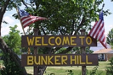
Bunker Hill, Illinois
Encyclopedia
Bunker Hill is a city in Macoupin County
, Illinois
, United States
. The population was 1,801 at the 2000 census.
In 1834, County Surveyor Luke Knowlton entered 80 acres (323,748.8 m²) of land that now cover the center of Bunker Hill. On 25 December 1835, Moses True of Salisbury, New Hampshire, John Tilden of Boston, Massachusetts, and Robert Smith of Alton, Illinois visited Lincoln and formed a company to plat a town and improve the surrounding countryside. By 1836, the settlement of Lincoln had been abandoned, prompting Moses and company to establish a new town, which became Bunker Hill in 1837.
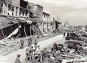
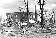 At 6:45am CST on 19 March 1948, a tornado
that originated in Alton, Illinois
blew through Bunker Hill, destroying the majority of the town's buildings and killing nineteen people. Although the tornado was only in town for less than a minute, the destruction was devastating. The downtown business district lost many of its buildings. The streets were impassable due to rubble from the storm. The newly renovated Meissner School was one of few buildings virtually undamaged by the tornado. A first aid station was set up in the school, with a temporary morgue in another classroom. By 9:00 am, ambulances from Alton, Carlinville
, Litchfield
, and Gillespie
arrived to transport the injured to local hospitals. By the end of the day, National Guard units, US Army units, the Red Cross, Salvation Army, American Legion, VFW, and Illinois State Police had arrived to restore order and provide assistance to the citizens of Bunker Hill.
The Army and National Guard established patrols to minimize looting, and the State Police set up road blocks to keep sightseers away. The Red Cross, Salvation Army, and Lebanon American Legion opened food stations to feed the volunteers and homeless citizens of the town. Bahn's Grocery Store donated their entire stock for the food stations. A temporary post office was opened in the lobby of the First National Bank. Local farmers brought their tractors and bulldozers to town to clear rubble and reopen the streets.
By evening, the Red Cross had pitched tents in front of Meissner School to house the newly homeless citizens. 126 people were injured and 19 killed by the tornado. Property damage was estimated between four and five million dollars. All five churches in Bunker Hill were destroyed by the tornado, prompting two local ministers, Rev. Burke of the First Congregational Church and Rev. Johnson of the Baptist Church, to conduct the Easter Sunday services on 28 March 1948 using a bulldozer as a pulpit. An estimated 500 residents and volunteers gathered at the center of town for the sermons before returning to work.
A brick pavilion stood in the middle of the intersection of Washington and Warren Streets prior to the tornado. The pavilion, which had been used as a bandstand for community events, was not rebuilt after the tornado, instead being replaced by a flagpole and memorial to local military veterans.
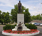
 Bunker Hill is the home of one of four statues of Abraham Lincoln sculpted by William Grandville Hastings. In 1904, Captain Charles Clinton, formerly of Company B of the First Missouri Voluntary Cavalry, donated the statue to the citizens of Bunker Hill in commemoration of the service of local veterans in Company B during the Civil War. The cost of the granite base was raised through voluntary subscription, and the bronze casting of Lincoln was shipped from Philadelphia.
On 7 September 1904, the statue was unveiled by Miss Mary True, daughter of the town's founder. An estimated 7000 attended the dedication of the statue following a parade through the center of town. Illinois Governor Richard Yates and Senator Shelby M. Collum were present to witness the ceremonies. Also present were local veterans of Company B John Dennison (Carlinville, IL), James G. Rumbolz (Bunker Hill, IL), Fred Dabel (Bunker Hill, IL), Herman Heuer (Dorsey, IL), James Lawrence (Carlinville, IL), James Pocklington (Carlinville, IL), John Brandenburger (Bunker Hill, IL), E.S. Williams (Bunker Hill, IL), and August Kardel (Upper Alton, IL). Captain Clinton was also present for the dedication.
A plaque mounted on the statue's base reads:
1904
In Ever Lasting Memory of
The Conflict By Which The Union
In Which They
Took Part This Statue of
Abraham Lincoln
Was Presented
To the Citizens of Bunker Hill
By the Soldiers of Company B
of the
First Missouri Cavalry, Charles Clinton
The statue also includes Lady Liberty kneeling at the base, etching the words "with malice toward none."
The Lincoln Statue rests in the middle of the intersection of North Washington (IL Route 159) and Fayette Streets.
The Bunker Hill Historical Museum, operated by the Bunker Hill Historical Society, is located in the old town hall in the first east block of Warren Street. The museum features exhibits on local history, including information on the town's churches, the Bunker Hill Military Academy, the 1948 tornado, and an early 20th century doctor's office. The museum is open every Saturday morning from 10:00am CST until 12:00pm CST.
North of town, on Prairie Dell Road, is Brittany Shooting Park. The Shoot Park hosts several Illinois State trap meets every year, and offers daily shooting.
, a north-south thoroughfare running from Illinois Route 16
in the north to Red Bud, Illinois
in the south, and the Bunker Hill Blacktop, running west to Brighton
as the Brighton-Bunker Hill Road and east to Staunton
and Illinois Route 4 as the Staunton-Bunker Hill Road. The nearest airport is the St. Louis Regional Airport
in Bethalto, Illinois
.
According to the United States Census Bureau
, the city has a total area of 1.2 square miles (3.1 km²), of which, 1.2 square miles (3.1 km²) of it is land and 0.04 square mile (0.1035995244 km²) of it (1.67%) is water.
of 2000, there were 1,801 people, 697 households, and 496 families residing in the city. The population density
was 1,526.9 people per square mile (589.3/km²). There were 742 housing units at an average density of 629.1 per square mile (242.8/km²). The racial makeup of the city was 97.50% White, 1.22% African American, 0.11% Asian, 0.28% from other races
, and 0.89% from two or more races. Hispanic or Latino of any race were 0.72% of the population.
There were 697 households out of which 35.6% had children under the age of 18 living with them, 55.8% were married couples
living together, 12.1% had a female householder with no husband present, and 28.8% were non-families. 26.1% of all households were made up of individuals and 14.1% had someone living alone who was 65 years of age or older. The average household size was 2.52 and the average family size was 3.02.
In the city the population was spread out with 26.0% under the age of 18, 8.4% from 18 to 24, 28.7% from 25 to 44, 20.4% from 45 to 64, and 16.4% who were 65 years of age or older. The median age was 37 years. For every 100 females there were 88.8 males. For every 100 females age 18 and over, there were 87.6 males.
The median income for a household in the city was $37,156, and the median income for a family was $45,885. Males had a median income of $35,227 versus $23,000 for females. The per capita income
for the city was $16,798. About 8.8% of families and 10.3% of the population were below the poverty line, including 14.3% of those under age 18 and 4.6% of those age 65 or over.
Macoupin County, Illinois
Macoupin County is a county located in the southwestern portion of the U.S. state of Illinois. According to the 2010 census, it has a population of 47,765, which is a decrease of 2.6% from 49,019 in 2000. The county seat is Carlinville. Macoupin County is an outlying county of the Metro-East region...
, Illinois
Illinois
Illinois is the fifth-most populous state of the United States of America, and is often noted for being a microcosm of the entire country. With Chicago in the northeast, small industrial cities and great agricultural productivity in central and northern Illinois, and natural resources like coal,...
, United States
United States
The United States of America is a federal constitutional republic comprising fifty states and a federal district...
. The population was 1,801 at the 2000 census.
Settlement
The original inhabitants of the Bunker Hill area were members of the Peoria, Kickapoo, and Winnebago Indian tribes. As pioneers arrived in Macoupin County, the site of the future Bunker Hill was settled in 1830. At that time, the area was known as Wolf Ridge, due to the presence of wolves in the vicinity. The first settler was Elijah Lincoln in 1830, who established a land claim one and a half miles southwest of present Bunker Hill. Shortly after he made his claim, Lincoln and a Mr. Tuttle laid out a town, named Lincoln after the first settler. The earliest post office in the area was established in 1833 a mile south of Lincoln. A school house was built around 1831, and was also used as the meeting hall for the Baptist denomination. The first church in the area was built by the Baptists. The second was the Congregational Church in Woodburn.In 1834, County Surveyor Luke Knowlton entered 80 acres (323,748.8 m²) of land that now cover the center of Bunker Hill. On 25 December 1835, Moses True of Salisbury, New Hampshire, John Tilden of Boston, Massachusetts, and Robert Smith of Alton, Illinois visited Lincoln and formed a company to plat a town and improve the surrounding countryside. By 1836, the settlement of Lincoln had been abandoned, prompting Moses and company to establish a new town, which became Bunker Hill in 1837.
The tornado of 1948
Tornado
A tornado is a violent, dangerous, rotating column of air that is in contact with both the surface of the earth and a cumulonimbus cloud or, in rare cases, the base of a cumulus cloud. They are often referred to as a twister or a cyclone, although the word cyclone is used in meteorology in a wider...
that originated in Alton, Illinois
Alton, Illinois
Alton is a city on the Mississippi River in Madison County, Illinois, United States, about north of St. Louis, Missouri. The population was 27,865 at the 2010 census. It is a part of the Metro-East region of the Greater St. Louis metropolitan area in Southern Illinois...
blew through Bunker Hill, destroying the majority of the town's buildings and killing nineteen people. Although the tornado was only in town for less than a minute, the destruction was devastating. The downtown business district lost many of its buildings. The streets were impassable due to rubble from the storm. The newly renovated Meissner School was one of few buildings virtually undamaged by the tornado. A first aid station was set up in the school, with a temporary morgue in another classroom. By 9:00 am, ambulances from Alton, Carlinville
Carlinville, Illinois
Carlinville is a city in Macoupin County, Illinois, United States. As of the 2000 Census, the population was 5,685, and 5,912 at a 2009 estimate. It is the county seat of Macoupin County, and so it is an outlying part of the Metro-East region of the Greater St...
, Litchfield
Litchfield, Illinois
Litchfield is a city in Montgomery County, Illinois, United States. The population was 6,815 at the 2000 census, and 6,588 in 2009. It is located in south central Illinois, south of Springfield and on the northern edge of the Greater St. Louis Metro-East area.-Attractions:The Ariston Cafe is one of...
, and Gillespie
Gillespie, Illinois
Gillespie is a city in Macoupin County, Illinois, United States. The population was 3,412 at the 2000 census.-Geography:Gillespie is located at ....
arrived to transport the injured to local hospitals. By the end of the day, National Guard units, US Army units, the Red Cross, Salvation Army, American Legion, VFW, and Illinois State Police had arrived to restore order and provide assistance to the citizens of Bunker Hill.
The Army and National Guard established patrols to minimize looting, and the State Police set up road blocks to keep sightseers away. The Red Cross, Salvation Army, and Lebanon American Legion opened food stations to feed the volunteers and homeless citizens of the town. Bahn's Grocery Store donated their entire stock for the food stations. A temporary post office was opened in the lobby of the First National Bank. Local farmers brought their tractors and bulldozers to town to clear rubble and reopen the streets.
By evening, the Red Cross had pitched tents in front of Meissner School to house the newly homeless citizens. 126 people were injured and 19 killed by the tornado. Property damage was estimated between four and five million dollars. All five churches in Bunker Hill were destroyed by the tornado, prompting two local ministers, Rev. Burke of the First Congregational Church and Rev. Johnson of the Baptist Church, to conduct the Easter Sunday services on 28 March 1948 using a bulldozer as a pulpit. An estimated 500 residents and volunteers gathered at the center of town for the sermons before returning to work.
A brick pavilion stood in the middle of the intersection of Washington and Warren Streets prior to the tornado. The pavilion, which had been used as a bandstand for community events, was not rebuilt after the tornado, instead being replaced by a flagpole and memorial to local military veterans.
Bunker Hill Military Academy
Bunker Hill was the home of the Bunker Hill Military Academy toward the end of the 19th, and beginning of the 20th centuries. The school opened in 1859 as the Bunker Hill Academy, but closed during the American Civil War. From 1862 until 1869, the building housed Bunker Hill's public school. In 1883, the military academy was established in the aging building, offering strict instruction to local children as well as the cadets. The Academy remained open until 1914. After the 1948 tornado, the grounds were donated to the American Legion, which built a local post and park on the site.The Lincoln Statue
On 7 September 1904, the statue was unveiled by Miss Mary True, daughter of the town's founder. An estimated 7000 attended the dedication of the statue following a parade through the center of town. Illinois Governor Richard Yates and Senator Shelby M. Collum were present to witness the ceremonies. Also present were local veterans of Company B John Dennison (Carlinville, IL), James G. Rumbolz (Bunker Hill, IL), Fred Dabel (Bunker Hill, IL), Herman Heuer (Dorsey, IL), James Lawrence (Carlinville, IL), James Pocklington (Carlinville, IL), John Brandenburger (Bunker Hill, IL), E.S. Williams (Bunker Hill, IL), and August Kardel (Upper Alton, IL). Captain Clinton was also present for the dedication.
A plaque mounted on the statue's base reads:
1904
In Ever Lasting Memory of
The Conflict By Which The Union
In Which They
Took Part This Statue of
Abraham Lincoln
Was Presented
To the Citizens of Bunker Hill
By the Soldiers of Company B
of the
First Missouri Cavalry, Charles Clinton
The statue also includes Lady Liberty kneeling at the base, etching the words "with malice toward none."
The Lincoln Statue rests in the middle of the intersection of North Washington (IL Route 159) and Fayette Streets.
Other attractions
The Bunker Hill City Cemetery, located on the Bunker Hill-Staunton Road, is home to the Soldiers Monument honoring those who fought and died for freedom and liberty.The Bunker Hill Historical Museum, operated by the Bunker Hill Historical Society, is located in the old town hall in the first east block of Warren Street. The museum features exhibits on local history, including information on the town's churches, the Bunker Hill Military Academy, the 1948 tornado, and an early 20th century doctor's office. The museum is open every Saturday morning from 10:00am CST until 12:00pm CST.
North of town, on Prairie Dell Road, is Brittany Shooting Park. The Shoot Park hosts several Illinois State trap meets every year, and offers daily shooting.
Transportation
Bunker Hill is centered at the intersection of Illinois Route 159Illinois Route 159
Illinois Route 159 is a north–south state road in southwestern Illinois. Its southern terminus is at Illinois Route 3 and Illinois Route 154 in Red Bud and its northern terminus at Illinois Route 16 in Royal Lakes. This is a distance of ....
, a north-south thoroughfare running from Illinois Route 16
Illinois Route 16
Illinois Route 16 is an arterial east–west highway in central Illinois. Its western terminus is at the Joe Page Bridge over the Illinois River in Hardin, while its eastern terminus is at Paris at Illinois Route 1 and U.S. Route 150, with Illinois Route 133. This is a distance of .- Route...
in the north to Red Bud, Illinois
Red Bud, Illinois
Red Bud is a city in Randolph County, Illinois. The population was 3,422 at the 2000 census.It is the home of the of Southwestern Illinois College.-Geography:Red Bud is located at ....
in the south, and the Bunker Hill Blacktop, running west to Brighton
Brighton, Illinois
Brighton is a village located mostly in Macoupin County, Illinois and partially in Jersey County, Illinois. As of the 2010 U.S. census, the village had a total population of 2,254. The village's current mayor is Wayne Schafer....
as the Brighton-Bunker Hill Road and east to Staunton
Staunton, Illinois
Staunton is a city in Macoupin County, Illinois, United States. The population was 5,030 at the 2000 census.-Geography:Staunton is located at ....
and Illinois Route 4 as the Staunton-Bunker Hill Road. The nearest airport is the St. Louis Regional Airport
St. Louis Regional Airport
St. Louis Regional Airport is a public airport located four miles east of the central business district of Alton, a city in Madison County, Illinois, United States...
in Bethalto, Illinois
Bethalto, Illinois
Bethalto is a village located in Madison County, Illinois, USA. Bethalto, like the rest of Madison County, is part of the Illinois Metro-East portion of the Greater St. Louis metropolitan area...
.
Geography
Bunker Hill is located at 39°2′29"N 89°57′3"W (39.041452, -89.950898).According to the United States Census Bureau
United States Census Bureau
The United States Census Bureau is the government agency that is responsible for the United States Census. It also gathers other national demographic and economic data...
, the city has a total area of 1.2 square miles (3.1 km²), of which, 1.2 square miles (3.1 km²) of it is land and 0.04 square mile (0.1035995244 km²) of it (1.67%) is water.
Demographics
As of the censusCensus
A census is the procedure of systematically acquiring and recording information about the members of a given population. It is a regularly occurring and official count of a particular population. The term is used mostly in connection with national population and housing censuses; other common...
of 2000, there were 1,801 people, 697 households, and 496 families residing in the city. The population density
Population density
Population density is a measurement of population per unit area or unit volume. It is frequently applied to living organisms, and particularly to humans...
was 1,526.9 people per square mile (589.3/km²). There were 742 housing units at an average density of 629.1 per square mile (242.8/km²). The racial makeup of the city was 97.50% White, 1.22% African American, 0.11% Asian, 0.28% from other races
Race (United States Census)
Race and ethnicity in the United States Census, as defined by the Federal Office of Management and Budget and the United States Census Bureau, are self-identification data items in which residents choose the race or races with which they most closely identify, and indicate whether or not they are...
, and 0.89% from two or more races. Hispanic or Latino of any race were 0.72% of the population.
There were 697 households out of which 35.6% had children under the age of 18 living with them, 55.8% were married couples
Marriage
Marriage is a social union or legal contract between people that creates kinship. It is an institution in which interpersonal relationships, usually intimate and sexual, are acknowledged in a variety of ways, depending on the culture or subculture in which it is found...
living together, 12.1% had a female householder with no husband present, and 28.8% were non-families. 26.1% of all households were made up of individuals and 14.1% had someone living alone who was 65 years of age or older. The average household size was 2.52 and the average family size was 3.02.
In the city the population was spread out with 26.0% under the age of 18, 8.4% from 18 to 24, 28.7% from 25 to 44, 20.4% from 45 to 64, and 16.4% who were 65 years of age or older. The median age was 37 years. For every 100 females there were 88.8 males. For every 100 females age 18 and over, there were 87.6 males.
The median income for a household in the city was $37,156, and the median income for a family was $45,885. Males had a median income of $35,227 versus $23,000 for females. The per capita income
Per capita income
Per capita income or income per person is a measure of mean income within an economic aggregate, such as a country or city. It is calculated by taking a measure of all sources of income in the aggregate and dividing it by the total population...
for the city was $16,798. About 8.8% of families and 10.3% of the population were below the poverty line, including 14.3% of those under age 18 and 4.6% of those age 65 or over.
External links
- Bunker Hill, Illinois - Homepage