
Bulkington, Wiltshire
Encyclopedia
Bulkington is a village and a civil parish in Wiltshire
, England
. The village is about 4.5 miles (7.2 km) west of Devizes
and a similar distance southeast of Melksham
.
Most of the local children go to primary school in Keevil
. The local secondary schools are in Market Lavington
, Devizes, Melksham and Trowbridge.
It was one of the villages featured in the 2003 BBC2 documentary A Country Parish
.
The village pub, which used to be called the Tipsy Toad, reopened as The Well in October 2009.
Excavations at Lawn Farm in 1994, have uncovered evidence of periodic occupation from the 12th century onwards with a first mention in historical records in 1217 (77 1997). There is also physical evidence of pre-medieval human activity represented by a tiny assemblage of worked flint, possibly Mesolithic or Neolithic in date and a sherd of Roman pot (90 1997).
Aligned ENE-WSW and flanked by two brooks, Bulkington brook to the east and Semington Brook to the west, the village was initially formed within the Edington. Edington Church contains a monument/tomb in the south transept, ascribed to ‘Thomas Bulkington’ - rebus Boc-in-tun, the Boc signifying a beech tree (xlvii 1939). The addition of the –ton has also been attributed to an organised community that probably occupied pastured land after the Domesday Book
was published in 1086 (xlviii 1939), whose records suggest that the area where Bulkington lies was woodland (xlviii 1939).
It is feasible that Thomas Bulkington may have been the donar of the original manor circa 1244 (90 1997) situated opposite the present day church (link with Manor Farm and the fieldworks behind it), and tithes of Bulkington before he joined the convent. His presence in the area is consolidated as a witness to the transfer of Keevil church to the monastery in 1393 (xlvii 1937; xx1982; xxxii 1902).
The Lambeth Parliamentary Surveys of 1649 state that Bulkington was part of the Keevil parish paying tithes to Holy Trinity of Winton. The monastery had a manor, a farm, customary rents and a rectorial tithe (xx 1982). Throughout time, Bulkington has had links with local gentry as the Fitzlans; Earls of Arundel; the Stourton family; Richard Vere; the Earl of Oxford and Thomas Barkesdale (xx 1882) .
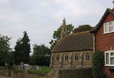
The layout of the village suggests two initial focal points, ‘The Cross’ monument and Christ Church highlighting a separation between worship and trade in the village.
The foundation of a church in Bulkington is steeped in tradition with many claiming of a pre-reformation church situated in the “New Leys” Field, (possibly near Seend), which is said to have donated a bell to Steeple Ashton when it was pulled down (xxxix 1917). It is possible that there was another unofficial church, possibly a temporary structure in Bulkington that may explain the notion of the ‘other’ church (xxxii). However, the historical records suggest that there was no church until 1860 when Chamberline made Bulkington a separate parish, later becoming a civil parish in the 1880s (90 1997), and erected the present day structure in an enclosure formerly known as Damers Close dating back to 1769 (90 1997).
'The Cross' monument, opposite ‘The Tipsy Toad' nee 'Well Inn’ originally consisted just of the present steps later used as the base for 'The Cross'. The cross itself was erected as the 20th Century War Memorial. Its origins are unknown although a report presented in 1903 may shed light on this when it describes a monument cross, recorded in the churchyard in Bulkington (xxxiii 1904).
‘The Cross’ was formerly a meet for the trading of sheep. This idea of a local market may suggest an agricultural link with the woollen towns of Steeple Ashton and Trowbridge and other surrounding market centres at Devizes, Melksham and Westbury.
There is evidence of Cloth factories at Bulkington (64 1969) at Mill House situated at the bottom of Mill Lane previously known as Bulkington or Gayford Mill. This was a fulling mill where woollens were finishing and cleansed through scouring and beating circa 1486; a Clothiers in 1524 and with the intervention of the Industrial Revolution, a tucking mill and gig mill in 1730 (64 1969). The closure of the mill can be attributed to evidence in 1831 of a cloth ‘factory’ closing in the parish (64 1969).
Evidence of occupying workforce is highlighted by the study of historical maps by AC archaeology that indicated two possible house platforms with other earthworks including a pond adjacent to a holloway connecting them to Brass Pan Bridge situated near the playing field pre-dating 1773 (88 1995).
Excavations have also uncovered post-Roman pottery originating from a number of sources including Crockerton near Warminster; Savernake Forest, Marlborough; Laverstock and Verwood near Salisbury and Bath (90 1997) thus indicating other movements and occupation in and around Bulkington. There are several green lanes now used as bridle paths that run close to the village including The Drove that extends to Marston, Worton and Erlestoke. The lane that leads to the Drove, across Brass Pan Bridge, carried on itself to the former hamlet known as Folly Green . There are also other tracks towards Keevil and the surrounding area (xxxiii 1904). With a possible pottery production centre at Potterne and the proximity to the River Avon at Melksham, joined by the aforementioned brooks, Bulkington was in no means isolated. This is exemplified by several examples of folklore from the village including links with the giant said to have lived at the Barge Inn Seend Cleeve and “Turpins Stone” which lies by Pentry Bridge depicting an inscription said to have run: -
“Dick Turpin’s dead and gone,
This stone’s put here to think upon.” (xxxix 1917)
During the 19th Century a dairy centre, known as Campbell Gray, situated where The Close lies was the main industry in the village until its closure a century later, replaced by husbandry.
Wiltshire
Wiltshire is a ceremonial county in South West England. It is landlocked and borders the counties of Dorset, Somerset, Hampshire, Gloucestershire, Oxfordshire and Berkshire. It contains the unitary authority of Swindon and covers...
, England
England
England is a country that is part of the United Kingdom. It shares land borders with Scotland to the north and Wales to the west; the Irish Sea is to the north west, the Celtic Sea to the south west, with the North Sea to the east and the English Channel to the south separating it from continental...
. The village is about 4.5 miles (7.2 km) west of Devizes
Devizes
Devizes is a market town and civil parish in Wiltshire, England. The town is about southeast of Chippenham and about east of Trowbridge.Devizes serves as a centre for banks, solicitors and shops, with a large open market place where a market is held once a week...
and a similar distance southeast of Melksham
Melksham
Melksham is a medium-sized English town, lying on the River Avon. It lies in the county of Wiltshire.It is situated southeast of the city of Bath, south of Chippenham, west of Devizes and north of Warminster on the A350 national route. The 2001 UK census cited Melksham as having 20,000...
.
Most of the local children go to primary school in Keevil
Keevil
Keevil is a village and civil parish in Wiltshire, England. The parish population has varied little since 1801.After the Second World War the barracks of RAF Keevil were used as a temporary home for Polish refugees. Today the small Ministry of Defence airfield at RAF Keevil is used for gliding at...
. The local secondary schools are in Market Lavington
Market Lavington
Market Lavington is a large village with a population of about 2,300 on the northern edge of Salisbury Plain in Wiltshire, England, near the market town of Devizes.-Status:...
, Devizes, Melksham and Trowbridge.
It was one of the villages featured in the 2003 BBC2 documentary A Country Parish
A Country Parish
A Country Parish is a British television documentary made by Tiger Aspect Productions for BBC2 which was first broadcast in 2003. The programme concerns the life of Jamie Allen who at the beginning of the series is a young, proactive curate from a working-class background in a none too prosperous...
.
The village pub, which used to be called the Tipsy Toad, reopened as The Well in October 2009.
Introduction
This brief history of Bulkington is very limited by the number of resources available and which have been taken mainly from editions of WANHS (Wiltshire Archaeological and Natural History Society). However it does give a general overview with many future avenues of research available to gather a clearer insight into the development of the village and its relationships with the surrounding environment.Excavations at Lawn Farm in 1994, have uncovered evidence of periodic occupation from the 12th century onwards with a first mention in historical records in 1217 (77 1997). There is also physical evidence of pre-medieval human activity represented by a tiny assemblage of worked flint, possibly Mesolithic or Neolithic in date and a sherd of Roman pot (90 1997).
Aligned ENE-WSW and flanked by two brooks, Bulkington brook to the east and Semington Brook to the west, the village was initially formed within the Edington. Edington Church contains a monument/tomb in the south transept, ascribed to ‘Thomas Bulkington’ - rebus Boc-in-tun, the Boc signifying a beech tree (xlvii 1939). The addition of the –ton has also been attributed to an organised community that probably occupied pastured land after the Domesday Book
Domesday Book
Domesday Book , now held at The National Archives, Kew, Richmond upon Thames in South West London, is the record of the great survey of much of England and parts of Wales completed in 1086...
was published in 1086 (xlviii 1939), whose records suggest that the area where Bulkington lies was woodland (xlviii 1939).
It is feasible that Thomas Bulkington may have been the donar of the original manor circa 1244 (90 1997) situated opposite the present day church (link with Manor Farm and the fieldworks behind it), and tithes of Bulkington before he joined the convent. His presence in the area is consolidated as a witness to the transfer of Keevil church to the monastery in 1393 (xlvii 1937; xx1982; xxxii 1902).
The Lambeth Parliamentary Surveys of 1649 state that Bulkington was part of the Keevil parish paying tithes to Holy Trinity of Winton. The monastery had a manor, a farm, customary rents and a rectorial tithe (xx 1982). Throughout time, Bulkington has had links with local gentry as the Fitzlans; Earls of Arundel; the Stourton family; Richard Vere; the Earl of Oxford and Thomas Barkesdale (xx 1882) .
The layout of the village suggests two initial focal points, ‘The Cross’ monument and Christ Church highlighting a separation between worship and trade in the village.
The foundation of a church in Bulkington is steeped in tradition with many claiming of a pre-reformation church situated in the “New Leys” Field, (possibly near Seend), which is said to have donated a bell to Steeple Ashton when it was pulled down (xxxix 1917). It is possible that there was another unofficial church, possibly a temporary structure in Bulkington that may explain the notion of the ‘other’ church (xxxii). However, the historical records suggest that there was no church until 1860 when Chamberline made Bulkington a separate parish, later becoming a civil parish in the 1880s (90 1997), and erected the present day structure in an enclosure formerly known as Damers Close dating back to 1769 (90 1997).
'The Cross' monument, opposite ‘The Tipsy Toad' nee 'Well Inn’ originally consisted just of the present steps later used as the base for 'The Cross'. The cross itself was erected as the 20th Century War Memorial. Its origins are unknown although a report presented in 1903 may shed light on this when it describes a monument cross, recorded in the churchyard in Bulkington (xxxiii 1904).
‘The Cross’ was formerly a meet for the trading of sheep. This idea of a local market may suggest an agricultural link with the woollen towns of Steeple Ashton and Trowbridge and other surrounding market centres at Devizes, Melksham and Westbury.
There is evidence of Cloth factories at Bulkington (64 1969) at Mill House situated at the bottom of Mill Lane previously known as Bulkington or Gayford Mill. This was a fulling mill where woollens were finishing and cleansed through scouring and beating circa 1486; a Clothiers in 1524 and with the intervention of the Industrial Revolution, a tucking mill and gig mill in 1730 (64 1969). The closure of the mill can be attributed to evidence in 1831 of a cloth ‘factory’ closing in the parish (64 1969).
Evidence of occupying workforce is highlighted by the study of historical maps by AC archaeology that indicated two possible house platforms with other earthworks including a pond adjacent to a holloway connecting them to Brass Pan Bridge situated near the playing field pre-dating 1773 (88 1995).
Excavations have also uncovered post-Roman pottery originating from a number of sources including Crockerton near Warminster; Savernake Forest, Marlborough; Laverstock and Verwood near Salisbury and Bath (90 1997) thus indicating other movements and occupation in and around Bulkington. There are several green lanes now used as bridle paths that run close to the village including The Drove that extends to Marston, Worton and Erlestoke. The lane that leads to the Drove, across Brass Pan Bridge, carried on itself to the former hamlet known as Folly Green . There are also other tracks towards Keevil and the surrounding area (xxxiii 1904). With a possible pottery production centre at Potterne and the proximity to the River Avon at Melksham, joined by the aforementioned brooks, Bulkington was in no means isolated. This is exemplified by several examples of folklore from the village including links with the giant said to have lived at the Barge Inn Seend Cleeve and “Turpins Stone” which lies by Pentry Bridge depicting an inscription said to have run: -
“Dick Turpin’s dead and gone,
This stone’s put here to think upon.” (xxxix 1917)
During the 19th Century a dairy centre, known as Campbell Gray, situated where The Close lies was the main industry in the village until its closure a century later, replaced by husbandry.