
Buchanan, Georgia
Encyclopedia
Buchanan is a city in Haralson County
, Georgia
, United States
. The population was 941 at the 2000 census. The city is the county seat
of Haralson County
.
Locally, the city's name is pronounced BUCK-an'-uhn, with the emphasis on the first syllable.
According to the United States Census Bureau
, the city has a total area of 1.7 square miles (4.4 km²), of which, 1.5 square miles (3.9 km²) of it is land and 0.2 square mile (0.517997622 km²) of it (11.90%) is water.
of 2000, there were 941 people, 345 households, and 221 families residing in the city. The population density
was 638.6 people per square mile (247.2/km²). There were 380 housing units at an average density of 257.9 per square mile (99.8/km²). The racial makeup of the city was 87.14% White, 11.37% African American, 0.11% Native American, 0.11% Asian, 0.11% from other races
, and 1.17% from two or more races. Hispanic or Latino of any race were 0.53% of the population.
There were 345 households out of which 27.0% had children under the age of 18 living with them, 46.1% were married couples
living together, 14.8% had a female householder with no husband present, and 35.7% were non-families. 33.6% of all households were made up of individuals and 17.7% had someone living alone who was 65 years of age or older. The average household size was 2.38 and the average family size was 3.02.
In the city the population was spread out with 22.8% under the age of 18, 8.0% from 18 to 24, 28.5% from 25 to 44, 21.5% from 45 to 64, and 19.2% who were 65 years of age or older. The median age was 38 years. For every 100 females there were 96.9 males. For every 100 females age 18 and over, there were 86.2 males.
The median income for a household in the city was $23,269, and the median income for a family was $26,964. Males had a median income of $24,205 versus $16,458 for females. The per capita income
for the city was $11,821. About 20.5% of families and 22.7% of the population were below the poverty line, including 23.4% of those under age 18 and 19.8% of those age 65 or over.
holds grades pre-school to grade twelve, that consists of four elementary schools, a middle school, and a high school. The district has 231 full-time teachers and over 3,766 students.
Haralson County, Georgia
Haralson County is a county located in the U.S. state of Georgia. It was created on January 26, 1856 and was named for Hugh A. Haralson. As of 2000, the population was 25,690. The 2007 Census Estimate shows a population of 28,718...
, Georgia
Georgia (U.S. state)
Georgia is a state located in the southeastern United States. It was established in 1732, the last of the original Thirteen Colonies. The state is named after King George II of Great Britain. Georgia was the fourth state to ratify the United States Constitution, on January 2, 1788...
, United States
United States
The United States of America is a federal constitutional republic comprising fifty states and a federal district...
. The population was 941 at the 2000 census. The city is the county seat
County seat
A county seat is an administrative center, or seat of government, for a county or civil parish. The term is primarily used in the United States....
of Haralson County
Haralson County, Georgia
Haralson County is a county located in the U.S. state of Georgia. It was created on January 26, 1856 and was named for Hugh A. Haralson. As of 2000, the population was 25,690. The 2007 Census Estimate shows a population of 28,718...
.
Locally, the city's name is pronounced BUCK-an'-uhn, with the emphasis on the first syllable.
Geography
Buchanan is located at 33°48′6"N 85°11′1"W (33.801726, -85.183506).According to the United States Census Bureau
United States Census Bureau
The United States Census Bureau is the government agency that is responsible for the United States Census. It also gathers other national demographic and economic data...
, the city has a total area of 1.7 square miles (4.4 km²), of which, 1.5 square miles (3.9 km²) of it is land and 0.2 square mile (0.517997622 km²) of it (11.90%) is water.
Demographics
As of the censusCensus
A census is the procedure of systematically acquiring and recording information about the members of a given population. It is a regularly occurring and official count of a particular population. The term is used mostly in connection with national population and housing censuses; other common...
of 2000, there were 941 people, 345 households, and 221 families residing in the city. The population density
Population density
Population density is a measurement of population per unit area or unit volume. It is frequently applied to living organisms, and particularly to humans...
was 638.6 people per square mile (247.2/km²). There were 380 housing units at an average density of 257.9 per square mile (99.8/km²). The racial makeup of the city was 87.14% White, 11.37% African American, 0.11% Native American, 0.11% Asian, 0.11% from other races
Race (United States Census)
Race and ethnicity in the United States Census, as defined by the Federal Office of Management and Budget and the United States Census Bureau, are self-identification data items in which residents choose the race or races with which they most closely identify, and indicate whether or not they are...
, and 1.17% from two or more races. Hispanic or Latino of any race were 0.53% of the population.
There were 345 households out of which 27.0% had children under the age of 18 living with them, 46.1% were married couples
Marriage
Marriage is a social union or legal contract between people that creates kinship. It is an institution in which interpersonal relationships, usually intimate and sexual, are acknowledged in a variety of ways, depending on the culture or subculture in which it is found...
living together, 14.8% had a female householder with no husband present, and 35.7% were non-families. 33.6% of all households were made up of individuals and 17.7% had someone living alone who was 65 years of age or older. The average household size was 2.38 and the average family size was 3.02.
In the city the population was spread out with 22.8% under the age of 18, 8.0% from 18 to 24, 28.5% from 25 to 44, 21.5% from 45 to 64, and 19.2% who were 65 years of age or older. The median age was 38 years. For every 100 females there were 96.9 males. For every 100 females age 18 and over, there were 86.2 males.
The median income for a household in the city was $23,269, and the median income for a family was $26,964. Males had a median income of $24,205 versus $16,458 for females. The per capita income
Per capita income
Per capita income or income per person is a measure of mean income within an economic aggregate, such as a country or city. It is calculated by taking a measure of all sources of income in the aggregate and dividing it by the total population...
for the city was $11,821. About 20.5% of families and 22.7% of the population were below the poverty line, including 23.4% of those under age 18 and 19.8% of those age 65 or over.
Haralson County School District
The Haralson County School DistrictHaralson County School District
The Haralson County School District is a public school district in Haralson County, Georgia, USA, based in Buchanan, Georgia, USA,. It serves the communities of Bowdon, Bremen, Buchanan, Budapest, Tallapoosa, Temple, and Waco, Georgia.-Schools:...
holds grades pre-school to grade twelve, that consists of four elementary schools, a middle school, and a high school. The district has 231 full-time teachers and over 3,766 students.
- Buchanan Elementary School
- Buchanan Primary School
- Tallapoosa Primary School
- West Haralson Elementary School
- Haralson County Middle School
- Haralson County High SchoolHaralson County High SchoolHaralson County High School is a public comprehensive high school located in Tallapoosa, Georgia, USA. The school is located at 1655 Georgia Highway 120, Tallapoosa, Georgia...
Video shot in Buchanan
(The following referenced matter is not hosted by Wikipedia, but by the well-known hosting sites YouTube and Google Video, and is made available under
the policies these Web sites follow. As with any content not appearing on the Wikipedia site, this material is subject to revision at any time without the knowledge of Wikipedia or any of its many contributors. However, at the time the following references have been made, there is no plausible reason to believe the content indicated appears without the consent of any copyright holders (express or through knowledgeable acquiescence) on account of the very public and popular nature of these hosting sites and the very long unmolested tenure of the particular items at issue.)
Outdoors
- Buchanan on Parade (shot 1957-1961)
- Buchanan town square eastern-side panorama (Aug. 2008)
— found by searching YouTube for Sbz_7KLR3xo - Fair on the Square (Sept. 2008)
— click the item on the page linked here labelled "Video survey of the Fair (unedited footage)" - Ghost Town musical band (Sept. 2008)
— found by searching YouTube for lMwKUk6ipNU - Gold prospecting expedition (Jan. 2009)
— found by searching YouTube for 19A235689B75A9A7 - Buchanan Georgia fair (issued Sep. 2009, shot 2006-2008)
- found by searching YouTube for igfGPYZowS8
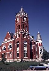
Historic Courthouse
- Haralson County Courthouse
- Naggin, rap music video by Ying Yang TwinsYing Yang TwinsThe Ying Yang Twins is an Atlanta-based American crunk rap duo consisting of Kaine and D-Roc . The group debuted in 2000 and rose to mainstream popularity in 2003 collaborating with Lil Jon in his single "Get Low"...
(2003)
— found by searching YouTube for mKm9hfxcHE8 - Historic Courthouse re-dedication (Nov. 2003)
— found by searching Google Video for "Historic Courthouse re-dedication" - For the Love of Poetry talk by Betty Candler (Apr. 2007)
— found by searching Google Video for "Buchanan-Haralson Public Library - Poetry" - Sons of the American Revolution talk by George Wheeless (May 2007)
— found by searching Google Video for "American Revolutionary War - SAR and ceremony" - Buchanan sesquicentennial ceremony (Dec. 2007)
— found by searching Google Video for "Buchanan 150th Anniversary - Joseph" - Talk by local artist Bud Jones (Apr. 2008)
— found by searching Google Video for "Some Wild Animals I have Known" - Dixie Times movie trailer (pub. Jun. 2009)
— found by searching YouTube for w_KxH4b3zCc
Little Creek School House (restored one-room structure)
- Tour and dedication ceremony (shot Sep. 2008)
— found by searching YouTube for YBz7RpQVffk
Hangar Venue (public musical social club)
Now Closed- Walkthrough during open hours (Aug. 2007)
— found by searching YouTube for SrGt4Tctv6Y - Walkthrough during open hours (Dec. 2007)
— found by searching YouTube for AlO_zYNTnhk