
Brocklesby, New South Wales
Encyclopedia
Brocklesby is a small village (or, small country town, as some people call it) situated 45 kilometres (28 mi) north-west of Albury
and 76 kilometres (47.2 mi) west of Holbrook
in Greater Hume Shire Council
in the Riverina
area of New South Wales
. Nearby neighbours are Walbundrie
to the north and Howlong
to the south.
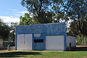
 Brocklesby village was once a main railway centre used for the transportation of grain. Nowadays the grain silos are all that remain and grain is transported by road truck. The area is now characterised by sheep, cattle and grain farmland.
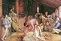
Tom Roberts
painted his celebrated masterpiece Shearing the Rams at Brocklesby Station (Sheep station
) near Corowa, NSW.
Brocklesby Post Office opened on 29 April 1893.
Brocklesby Shop opened in mid 2010.
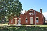
 Brocklesby, although having only a very small population prides itself on having an active community, including a long-standing pigeon club.(The pigeon shead was taken down in 2011.) Town buildings include the public hall, a recreation reserve, local primary school and pre-school, and since 2000 a public hotel which is owned by the Greater Hume Shire Council
and operates under a community licence.
Albury, New South Wales
Albury is a major regional city in New South Wales, Australia, located on the Hume Highway on the northern side of the Murray River. It is located wholly within the boundaries of the City of Albury Local Government Area...
and 76 kilometres (47.2 mi) west of Holbrook
Holbrook, New South Wales
Holbrook is a small town in Southern New South Wales, Australia. It is on the Hume Highway, 356 km North-East of Melbourne and 491 km south-west of Sydney between Tarcutta and Albury. The town is in the Greater Hume Shire Council area which was established in May 2004 from the merger of...
in Greater Hume Shire Council
Greater Hume Shire Council
Greater Hume Shire Council is a Local Government Area of New South Wales, Australia. The Council was formed in 2004 incorporating Culcairn Shire, the majority of Holbrook Shire and part of Hume Shire....
in the Riverina
Riverina
The Riverina is an agricultural region of south-western New South Wales , Australia. The Riverina is distinguished from other Australian regions by the combination of flat plains, warm to hot climate and an ample supply of water for irrigation. This combination has allowed the Riverina to develop...
area of New South Wales
New South Wales
New South Wales is a state of :Australia, located in the east of the country. It is bordered by Queensland, Victoria and South Australia to the north, south and west respectively. To the east, the state is bordered by the Tasman Sea, which forms part of the Pacific Ocean. New South Wales...
. Nearby neighbours are Walbundrie
Walbundrie, New South Wales
Walbundrie is a village in the eastern Riverina district of New South Wales, Australia. The village is located south-west of the state capital, Sydney and north of Melbourne. Situated on the bank of the Billabong Creek, at the 2006 census, Walbundrie had a population of 190. Walbundrie is in...
to the north and Howlong
Howlong, New South Wales
Howlong is a town west of Albury, and is situated on the Murray River which separates the Australian states of New South Wales and Victoria. The town is located on the Riverina Highway. There is a bridge across the Murray into Victoria. Howlong is in the Corowa Shire Local government area...
to the south.
Historical significance
Tom Roberts
Tom Roberts
Thomas William Roberts , usually known simply as Tom, was a prominent Australian artist and a key member of the Heidelberg School.-Life:...
painted his celebrated masterpiece Shearing the Rams at Brocklesby Station (Sheep station
Sheep station
A sheep station is a large property in Australia or New Zealand whose main activity is the raising of sheep for their wool and meat. In Australia, sheep stations are usually in the south-east or south-west of the country. In New Zealand the Merinos are usually in the high country of the South...
) near Corowa, NSW.
Brocklesby Post Office opened on 29 April 1893.
Brocklesby Shop opened in mid 2010.
Avro Anson plane crash
The area is also infamous for a historical crash landing of two twin-engine Avro Anson training planes which collided overhead and became entangled with one plane sitting on top of the other. The two crew members of the lower plane parachuted to safety whilst Leading Aircraftsman Leonard Fuller, the pilot of the top plane undertook a daring and heroic flight of 8 kilometres before belly landing the two planes single-handed in a paddock approximately 4 kilometres (2 mi) from the town.Brocklesby today
Greater Hume Shire Council
Greater Hume Shire Council is a Local Government Area of New South Wales, Australia. The Council was formed in 2004 incorporating Culcairn Shire, the majority of Holbrook Shire and part of Hume Shire....
and operates under a community licence.