

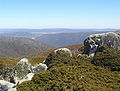
Brindabella Ranges
Encyclopedia
Mountain
Image:Himalaya_annotated.jpg|thumb|right|The Himalayan mountain range with Mount Everestrect 58 14 160 49 Chomo Lonzorect 200 28 335 52 Makalurect 378 24 566 45 Mount Everestrect 188 581 920 656 Tibetan Plateaurect 250 406 340 427 Rong River...
range located on the border between New South Wales
New South Wales
New South Wales is a state of :Australia, located in the east of the country. It is bordered by Queensland, Victoria and South Australia to the north, south and west respectively. To the east, the state is bordered by the Tasman Sea, which forms part of the Pacific Ocean. New South Wales...
and the Australian Capital Territory
Australian Capital Territory
The Australian Capital Territory, often abbreviated ACT, is the capital territory of the Commonwealth of Australia and is the smallest self-governing internal territory...
, Australia
Australia
Australia , officially the Commonwealth of Australia, is a country in the Southern Hemisphere comprising the mainland of the Australian continent, the island of Tasmania, and numerous smaller islands in the Indian and Pacific Oceans. It is the world's sixth-largest country by total area...
. The ranges rise to the west of Canberra
Canberra
Canberra is the capital city of Australia. With a population of over 345,000, it is Australia's largest inland city and the eighth-largest city overall. The city is located at the northern end of the Australian Capital Territory , south-west of Sydney, and north-east of Melbourne...
, the capital city of Australia, and include the Namadgi National Park
Namadgi National Park
Namadgi National Park is located in the southwestern part of the Australian Capital Territory, bordering Kosciuszko National Park in New South Wales. It lies approximately 40 km southwest of Canberra, and makes up approximately 46% of the ACT's land area....
in the A.C.T. and Bimberi Nature Reserve
Bimberi Nature Reserve
The Bimberi Nature Reserve is a reserve that comprises part of the Brindabella Ranges about 30 kilometres south-west of Canberra. It lies between Namadgi and Kosciuszko National Parks...
and Brindabella National Park
Brindabella National Park
Brindabella National Park is a national park in New South Wales, Australia, 267 km southwest of Sydney in the Brindabella Ranges.On 7 November 2008 The Park was added to the Australian National Heritage List as one of eleven areas constituting the Australian Alps National Parks and...
in New South Wales
New South Wales
New South Wales is a state of :Australia, located in the east of the country. It is bordered by Queensland, Victoria and South Australia to the north, south and west respectively. To the east, the state is bordered by the Tasman Sea, which forms part of the Pacific Ocean. New South Wales...
. The Brindabellas are visible to the west of Canberra
Canberra
Canberra is the capital city of Australia. With a population of over 345,000, it is Australia's largest inland city and the eighth-largest city overall. The city is located at the northern end of the Australian Capital Territory , south-west of Sydney, and north-east of Melbourne...
and form an important part of the city's landscape.
History and Geography
The name is said to mean “two kangaroo rats” in the language of the local AboriginesIndigenous Australians
Indigenous Australians are the original inhabitants of the Australian continent and nearby islands. The Aboriginal Indigenous Australians migrated from the Indian continent around 75,000 to 100,000 years ago....
. However, another account states that "Brindy brindy" was a local term meaning water running over rocks and bella was presumably added by the Europeans as in "bella vista".
Brindabella National Park
Brindabella National Park
Brindabella National Park is a national park in New South Wales, Australia, 267 km southwest of Sydney in the Brindabella Ranges.On 7 November 2008 The Park was added to the Australian National Heritage List as one of eleven areas constituting the Australian Alps National Parks and...
lies north-west of the NSW-ACT border abutting Namadgi National Park
Namadgi National Park
Namadgi National Park is located in the southwestern part of the Australian Capital Territory, bordering Kosciuszko National Park in New South Wales. It lies approximately 40 km southwest of Canberra, and makes up approximately 46% of the ACT's land area....
and covers an area of 213.6 square kilometres.
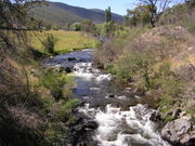
Brindabella Valley (in the middle of the range, is 40 km south-west of Canberra and 350 km from Sydney
Sydney
Sydney is the most populous city in Australia and the state capital of New South Wales. Sydney is located on Australia's south-east coast of the Tasman Sea. As of June 2010, the greater metropolitan area had an approximate population of 4.6 million people...
. It is on the edge of the Snowy Mountains
Snowy Mountains
The Snowy Mountains, known informally as "The Snowies", are the highest Australian mountain range and contain the Australian mainland's highest mountain, Mount Kosciuszko, which reaches 2,228 metres AHD, approximately 7310 feet....
. The Goodradigbee River
Goodradigbee River
The Goodradigbee River is in south-eastern New South Wales, Australia. It flows into Burrinjuck Dam and thus is a tributary of the Murrumbidgee River....
flows through the valley.
Before European settlement it was inhabited by the Ngunnawal, Walgalu and Djimantan Aborigines. The area was first settled in the 1830s by European squatters with land first being purchased in 1849. Gold was found in 1860 but mined from the 1880s; in 1887 the Brindabella Gold Mining Company was formed. Mining continued til 1910. It is now an agricultural area.
Australian author Miles Franklin
Miles Franklin
Stella Maria Sarah Miles Franklin, known as Miles Franklin was an Australian writer and feminist who is best known for her novel My Brilliant Career, published in 1901...
grew up in the Brindabella Valley and wrote an autobiographical work, Childhood at Brindabella, which told of her early life in the valley.
Snow country
The most northerly ski fields in Australia are located in the A.C.T.Australian Capital Territory
The Australian Capital Territory, often abbreviated ACT, is the capital territory of the Commonwealth of Australia and is the smallest self-governing internal territory...
- in the Brindabella Ranges and include the Namadgi National Park
Namadgi National Park
Namadgi National Park is located in the southwestern part of the Australian Capital Territory, bordering Kosciuszko National Park in New South Wales. It lies approximately 40 km southwest of Canberra, and makes up approximately 46% of the ACT's land area....
in the A.C.T. and Bimberi Nature Reserve
Bimberi Nature Reserve
The Bimberi Nature Reserve is a reserve that comprises part of the Brindabella Ranges about 30 kilometres south-west of Canberra. It lies between Namadgi and Kosciuszko National Parks...
and Brindabella National Park
Brindabella National Park
Brindabella National Park is a national park in New South Wales, Australia, 267 km southwest of Sydney in the Brindabella Ranges.On 7 November 2008 The Park was added to the Australian National Heritage List as one of eleven areas constituting the Australian Alps National Parks and...
in New South Wales
New South Wales
New South Wales is a state of :Australia, located in the east of the country. It is bordered by Queensland, Victoria and South Australia to the north, south and west respectively. To the east, the state is bordered by the Tasman Sea, which forms part of the Pacific Ocean. New South Wales...
. The highest mountain in the ACT is Bimberi Peak
Bimberi Peak
Bimberi Peak or Mount Bimberi is the highest mountain in the Australian Capital Territory at 1912 metres. It is located on the border between New South Wales and the ACT, the NSW portion in Kosciuszko National Park and the ACT portion in Namadgi National Park...
, which lies above the treeline at 1912 metres, at the northern edge of the Snowy Mountains
Snowy Mountains
The Snowy Mountains, known informally as "The Snowies", are the highest Australian mountain range and contain the Australian mainland's highest mountain, Mount Kosciuszko, which reaches 2,228 metres AHD, approximately 7310 feet....
.
A ski chalet was constructed at Mount Franklin in 1938 to service the Canberra Alpine Club. Ski runs were cleared and ski tows were improvised. The chalet later operated as a museum before being destroyed in the 2003 bushfires
2003 Canberra bushfires
The Canberra bushfires of 2003 caused severe damage to the outskirts of Canberra, the Australian capital city. Almost 70% of the Australian Capital Territory’s pasture, forests and nature parks were severely damaged, and most of the renowned Mount Stromlo Observatory was destroyed...
. A new shelter designed and built by University of Adelaide students opened in 2008. Today, cross country skiing is possible in the area, when conditions allow. Cross Country skiing is also practised at Mount Gingera
Mount Gingera
Mount Gingera is the second highest mountain in the Australian Capital Territory. The mountain is the most prominent snow covered peak to be seen from Canberra in winter. It is part of the Brindabella Ranges on the border of the ACT and New South Wales...
, which rises above the city of Canberra to an elevation of 1855m, and is the most prominent snow covered peak above the city.
Snow play is available at Corin Forest, near Canberra, at an elevation of 1200m. A development plan was drafted following the 2003 Canberra bushfires which would see three 600m chairlifts installed together with snowmaking
Snowmaking
Snowmaking is the production of snow by forcing water and pressurized air through a "snow gun" or "snow cannon", on ski slopes. Snowmaking is mainly used at ski resorts to supplement natural snow. This allows ski resorts to improve the reliability of their snow cover and to extend their ski...
facilities and accommodation at this site.