
Bramwell, West Virginia
Encyclopedia
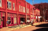
Bramwell is a town in Mercer County
, West Virginia
, United States
, along the Bluestone River
. The population was 426 at the 2000 census. It is part of the Bluefield
, WV-VA
micropolitan area
which has a population of 107,578.
According to the United States Census Bureau
, the town has a total area of 0.6 square miles (1.6 km²), all land.
In 1910 part of the downtown area was destroyed by a major fire.
In 1984 the town was named to the National Register of Historic Places by the US Dept. of the Interior.
of 2000, there were 426 people, 189 households, and 120 families residing in the town. The population density
was 712.5 inhabitants per square mile (274.1/km²). There were 237 housing units at an average density of 396.4 per square mile (152.5/km²). The racial makeup of the town was 89.67% White, 9.86% African American, and 0.47% from two or more races. Hispanic or Latino of any race were 0.47% of the population.
There were 189 households out of which 16.4% had children under the age of 18 living with them, 44.4% were married couples
living together, 14.8% had a female householder with no husband present, and 36.0% were non-families. 33.9% of all households were made up of individuals and 19.6% had someone living alone who was 65 years of age or older. The average household size was 2.25 and the average family size was 2.88.
In the town the population was spread out with 17.1% under the age of 18, 8.5% from 18 to 24, 21.6% from 25 to 44, 29.1% from 45 to 64, and 23.7% who were 65 years of age or older. The median age was 47 years. For every 100 females there were 86.8 males. For every 100 females age 18 and over, there were 82.0 males.
The median income for a household in the town was $21,979, and the median income for a family was $32,396. Males had a median income of $22,159 versus $15,250 for females. The per capita income
for the town was $13,410. About 9.9% of families and 15.7% of the population were below the poverty line, including 26.8% of those under age 18 and 16.5% of those age 65 or over.
August 24, 2008- In W. Va, Unexpected Riches, Washington Post, http://www.washingtonpost.com/wp-dyn/content/article/2008/08/22/AR2008082201647.html
Mercer County, West Virginia
-External links:* * * * * * *...
, West Virginia
West Virginia
West Virginia is a state in the Appalachian and Southeastern regions of the United States, bordered by Virginia to the southeast, Kentucky to the southwest, Ohio to the northwest, Pennsylvania to the northeast and Maryland to the east...
, United States
United States
The United States of America is a federal constitutional republic comprising fifty states and a federal district...
, along the Bluestone River
Bluestone River
The Bluestone River is a tributary of the New River, 77 mi long, in southwestern Virginia and southern West Virginia in the United States. Via the New, Kanawha and Ohio Rivers, it is part of the watershed of the Mississippi River...
. The population was 426 at the 2000 census. It is part of the Bluefield
Bluefield, West Virginia
Bluefield is a city in Mercer County, West Virginia, United States. The population was 10,447 at the 2010 census. It is also the core city of the Bluefield WV-VA micropolitan area which has a population of 107,342.-Geography & Climate:...
, WV-VA
Virginia
The Commonwealth of Virginia , is a U.S. state on the Atlantic Coast of the Southern United States. Virginia is nicknamed the "Old Dominion" and sometimes the "Mother of Presidents" after the eight U.S. presidents born there...
micropolitan area
Bluefield micropolitan area
The Bluefield Micropolitan Statistical Area, as defined by the United States Census Bureau, is an area consisting of two counties – one in West Virginia and one in Virginia – anchored by the city of Bluefield, West Virginia....
which has a population of 107,578.
Geography
Bramwell is located at 37°19′32"N 81°18′45"W (37.325425, -81.312474).According to the United States Census Bureau
United States Census Bureau
The United States Census Bureau is the government agency that is responsible for the United States Census. It also gathers other national demographic and economic data...
, the town has a total area of 0.6 square miles (1.6 km²), all land.
History
In the 1880s the region around Bramwell,WV began to rapidly grow as a coal mining center with several coal camps operating in the area. The town of Bramwell, WV was officially established in 1888. It was named after J.H. Bramwell, a civil engineer. In the late 1800s the town acquired some notoriety for having the largest number of millionaires per capita in the US. Numerous large homes were built in the town by wealthy coal operators.In 1910 part of the downtown area was destroyed by a major fire.
In 1984 the town was named to the National Register of Historic Places by the US Dept. of the Interior.
Demographics
As of the censusCensus
A census is the procedure of systematically acquiring and recording information about the members of a given population. It is a regularly occurring and official count of a particular population. The term is used mostly in connection with national population and housing censuses; other common...
of 2000, there were 426 people, 189 households, and 120 families residing in the town. The population density
Population density
Population density is a measurement of population per unit area or unit volume. It is frequently applied to living organisms, and particularly to humans...
was 712.5 inhabitants per square mile (274.1/km²). There were 237 housing units at an average density of 396.4 per square mile (152.5/km²). The racial makeup of the town was 89.67% White, 9.86% African American, and 0.47% from two or more races. Hispanic or Latino of any race were 0.47% of the population.
There were 189 households out of which 16.4% had children under the age of 18 living with them, 44.4% were married couples
Marriage
Marriage is a social union or legal contract between people that creates kinship. It is an institution in which interpersonal relationships, usually intimate and sexual, are acknowledged in a variety of ways, depending on the culture or subculture in which it is found...
living together, 14.8% had a female householder with no husband present, and 36.0% were non-families. 33.9% of all households were made up of individuals and 19.6% had someone living alone who was 65 years of age or older. The average household size was 2.25 and the average family size was 2.88.
In the town the population was spread out with 17.1% under the age of 18, 8.5% from 18 to 24, 21.6% from 25 to 44, 29.1% from 45 to 64, and 23.7% who were 65 years of age or older. The median age was 47 years. For every 100 females there were 86.8 males. For every 100 females age 18 and over, there were 82.0 males.
The median income for a household in the town was $21,979, and the median income for a family was $32,396. Males had a median income of $22,159 versus $15,250 for females. The per capita income
Per capita income
Per capita income or income per person is a measure of mean income within an economic aggregate, such as a country or city. It is calculated by taking a measure of all sources of income in the aggregate and dividing it by the total population...
for the town was $13,410. About 9.9% of families and 15.7% of the population were below the poverty line, including 26.8% of those under age 18 and 16.5% of those age 65 or over.
External links
August 24, 2008- In W. Va, Unexpected Riches, Washington Post, http://www.washingtonpost.com/wp-dyn/content/article/2008/08/22/AR2008082201647.html