
Bow Road tube station
Encyclopedia
Bow Road tube station is on the District
and Hammersmith & City
lines of the London Underground
. It is on Bow Road
in Bow, east London
, about 300 metres from Bow Church DLR station
and is in fare zone 2. Out of station interchange (OSI) is allowed between the stations.
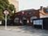
The station was opened in 1902 by the Whitechapel and Bow Railway (which was later incorporated into the District Line), with the Hammersmith & City Line (then the Metropolitan Line
) following in 1936. The station booking hall is a Grade II listed building.
Bow Road marks the point where westbound trains from Upminster
and Barking
enter a tunnel; the gradient of the tunnel approach, which is to the east of the station, is 1 in 28, the steepest on the tube network.
The Great Eastern Railway
Bow Road railway station
, which closed in 1949, stood on the opposite of Bow Road.
District Line
The District line is a line of the London Underground, coloured green on the Tube map. It is a "sub-surface" line, running through the central area in shallow cut-and-cover tunnels. It is the busiest of the sub-surface lines. Out of the 60 stations served, 25 are underground...
and Hammersmith & City
Hammersmith & City Line
The Hammersmith & City line is a subsurface London Underground line. It connects Hammersmith in the west with Barking in the east, running through the northern part of central London. It is coloured salmon pink on the Tube map...
lines of the London Underground
London Underground
The London Underground is a rapid transit system serving a large part of Greater London and some parts of Buckinghamshire, Hertfordshire and Essex in England...
. It is on Bow Road
Bow Road
Bow Road is a thoroughfare in Bow, Tower Hamlets, London, England. The road forms part of the A11, running from Aldgate to Norwich in Norfolk. To the west the road becomes Mile End Road, and to the east at the Bow Interchange roundabout, there is a junction with the A12.The College of Technology...
in Bow, east London
Bow, London
Bow is an area of London, England, United Kingdom in the London Borough of Tower Hamlets. It is a built-up, mostly residential district located east of Charing Cross, and is a part of the East End.-Bridges at Bowe:...
, about 300 metres from Bow Church DLR station
Bow Church DLR station
Bow Church station is a station on the Docklands Light Railway on Bow Road, in the Bow neighbourhood of east London. The station is located on the DLR's Stratford branch, between Devons Road and Pudding Mill Lane stations and is in Travelcard Zone 2. It is within 300 m walking distance of Bow...
and is in fare zone 2. Out of station interchange (OSI) is allowed between the stations.
The station was opened in 1902 by the Whitechapel and Bow Railway (which was later incorporated into the District Line), with the Hammersmith & City Line (then the Metropolitan Line
Metropolitan Line
The Metropolitan line is part of the London Underground. It is coloured in Transport for London's Corporate Magenta on the Tube map and in other branding. It was the first underground railway in the world, opening as the Metropolitan Railway on 10 January 1863...
) following in 1936. The station booking hall is a Grade II listed building.
Bow Road marks the point where westbound trains from Upminster
Upminster station
Upminster station is a London Underground and National Rail station located in Upminster in the London Borough of Havering and in London fare zone 6. Located east-northeast of Charing Cross, it is the easternmost station on the London Underground network and the eastern terminus of the District...
and Barking
Barking station
Barking station is a railway station served by National Rail and London Underground services. It is located in Barking in the London Borough of Barking and Dagenham in east London, England. The station is in Zone 4, has nine platforms, and is managed by c2c. It has been proposed that ownership of...
enter a tunnel; the gradient of the tunnel approach, which is to the east of the station, is 1 in 28, the steepest on the tube network.
The Great Eastern Railway
Great Eastern Railway
The Great Eastern Railway was a pre-grouping British railway company, whose main line linked London Liverpool Street to Norwich and which had other lines through East Anglia...
Bow Road railway station
Bow Road railway station
Bow Road railway station was in Bow, London on the opposite side of Bow Road from Bow Road tube station.It was opened on the south side of Bow Road in 1876 by the Great Eastern Railway, between Stratford station and the now closed Burdett Road station. It was resited in 1892 to the north side of...
, which closed in 1949, stood on the opposite of Bow Road.