
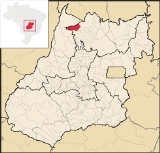
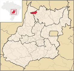
Bonópolis
Encyclopedia
| Bonópolis | |
|---|---|
| State | Goiás Goiás Goiás is a state of Brazil, located in the central part of the country. The name Goiás comes from the name of an indigenous community... |
| Area: | 1,628 km² |
| Population: | 3,160 (IBGE 2007) |
| Urban population: | 1,265 |
| Population density: | 1.94 inhab/km² |
| Population growth rate: | 2,84% |
| Elevation: | 290 m above sea level |
| Postcode (CEP): | 76555-000 |
| Became a city: | 1997 |
| Mayor: | Edilberto Moura Silva |
| Distance to Goiânia Goiânia -Climate:The city has a tropical wet and dry climate with an average temperature of . There's a wet season, from October to April, and a dry one, from May to September. Annual rainfall is around 1,520 mm.... : |
463 km. |
| IBGE statistical microregion: | Porangatu Microregion Porangatu Microregion The Porangatu Microregion is a statistical region created by IBGE in north-central Goiás state, Brazil. The most important city is Porangatu... |
| Website: | none |
Town
A town is a human settlement larger than a village but smaller than a city. The size a settlement must be in order to be called a "town" varies considerably in different parts of the world, so that, for example, many American "small towns" seem to British people to be no more than villages, while...
and municipality
Municipality
A municipality is essentially an urban administrative division having corporate status and usually powers of self-government. It can also be used to mean the governing body of a municipality. A municipality is a general-purpose administrative subdivision, as opposed to a special-purpose district...
in north Goiás
Goiás
Goiás is a state of Brazil, located in the central part of the country. The name Goiás comes from the name of an indigenous community...
state, Brazil
Brazil
Brazil , officially the Federative Republic of Brazil , is the largest country in South America. It is the world's fifth largest country, both by geographical area and by population with over 192 million people...
. It is largely rural with a substantial cattle herd.
Location
- Highway connections from GoiâniaGoiânia-Climate:The city has a tropical wet and dry climate with an average temperature of . There's a wet season, from October to April, and a dry one, from May to September. Annual rainfall is around 1,520 mm....
: GO-080 / NerópolisNerópolisNerópolis is a small city and municipality in central Goiás state, Brazil.-Location:The municipality is part of the metropolitan region of Goiânia, which is 42 kilometers to the west. It is nationally known as the city of garlic and sweets...
/ BR-153 / Jaraguá / GO-080 / GoianésiaGoianésiaGoianésia is a municipality in the state of Goiás, Brazil. It is a large producer of sugarcane for production of alcohol used as a source of fuel.-Location:...
/ Barro AltoBarro AltoBarro Alto is a small town and municipality in northern Goiás state, Brazil, famous for its nickel mine and production of rubber. The population was 6,446 in 2007 and the total area of the municipality was 1,231.8 km².-Location:...
/ GO-342 / UruaçuUruaçuUruaçu is a small city and municipality in north Goiás state, Brazil.-Geography:Uruaçu is located north of Anápolis and Goiânia on the important interstate highway BR-153, which links Brasília to Belém. It is 269 km. from Goiânia and 244 km. from Brasília...
/ CampinorteCampinorteCampinorte is a small city and municipality in north-central Goiás state, Brazil. The population was 9,697 in a total area of 1,068 km².-Location:...
/ GO-329 / GO-080 / Estrela do NorteEstrela do NorteEstrela do Norte refers to:*A municipality in the state of São Paulo, Brazil. See Estrela do Norte, São Paulo.*A municipality in the state of Goiás, Brazil. See Estrela do Norte, Goiás.*A football club from Cachoeiro de Itapemirim, Brazil....
/ GO-241/ MutunópolisMutunópolisMutunópolis is a small town and municipality in north Goiás state, Brazil.-Location:Mutunópolis is located in the extreme north of the state, 38 km south of the important regional center of Porangatu...
/ GO-241 / (70 km unpaved).
Bonópolis is surrounded by the following municipalities:
- north: Novo PlanaltoNovo PlanaltoNovo Planalto is a small town and municipality in north Goiás state, Brazil.Novo Planalto is located in the São Miguel do Araguaia Microregion, 47 kilometers east of São Miguel on highway GO-244. It is on the boundary dividing the state of Goiás with Tocantins. The same highway connects Novo...
- east: PorangatuPorangatuParangatu is a town in Goiás state, Brazil-Geography:Parangatu is in its own microregion, Porangatu Microregion, of 226,766 inhabitants in an area of 35.287 km²; 426 km from the state capital, Goiânia. This microregion serves as a nucleus for eighteen municipalities in the north of Goiás state...
- west: São Miguel do AraguaiaSão Miguel do AraguaiaSão Miguel do Araguaia is city in northeastern Goiás state, Brazil. It is the northernmost municipality in Goiás, one of the largest too, and a major producer of cattle....
- south: AmaralinaAmaralinaAmaralina is a small town and municipality in north Goiás state, Brazil.-Location:*Distance from Goiânia: 485 km.*Highway access from Goiânia: GO-080 / Nerópolis / BR-153 / Jaraguá / GO-080 / Goianésia / Barro Alto / GO-342 / Uruaçu / Campinorte / GO-329.Amaralina is surrounded by the...
The economy
The main economic activities are cattle raising (134,000 head in 2006) and plantations of rice (1,560 tons in 650 hectares planted), sugarcane, manioc (2,400 tons in 150 hectares planted), corn (1800 tons in 600 hectares planted), and soybeans (4,050 tons in 1,500 hectares planted. In 2006 there were 402 farms with a total area of 198,313 hectares, of which 2,074 hectares were planted. Farming occupied around 1,200 workers. Most of the farms were involved in livestock raising. There were no banks in 2007.Health and education
There were 4 schools with 1,113 students in 2006. Bonópolis is one of the poorest municipalities in the state with a Municipal Human Development IndexHuman Development Index
The Human Development Index is a composite statistic used to rank countries by level of "human development" and separate "very high human development", "high human development", "medium human development", and "low human development" countries...
rating of 0.683
- State ranking: 222 (out of 242 municipalities)
- National ranking: 3255 (out of 5507 municipalities)
See also
- List of municipalities in Goiás
- Microregions of Goiás