
Bolivar, Missouri
Encyclopedia
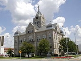
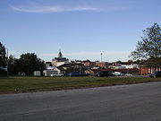
Bolivar is the county seat
of Polk County
, Missouri
, United States
. The population was 10,325 at the 2010 census
. The city was named for Bolivar, Tennessee
, home to many of the original settlers, and like that city its name is pronounced to rhyme with Oliver. The town is perhaps best known as the location of Southwest Baptist University
and it was ranked number 87 on a list of 100 Best Small Towns in America in 1995. Bolivar is part of the Springfield, Missouri
Metropolitan Statistical Area
. Bolivar is named after the South American historical figure, Simón Bolívar
, who was nicknamed El Libertador (The Liberator). In another nod to history, the local high school, Bolivar High School, calls its sports teams the Liberators.
 According to the United States Census Bureau
, the city has a total area of 6.3 square miles (16.3 km²), all of it land.
of 2000, there were 9,143 people, 3,318 households, and 2,067 families residing in the city. The population density
was 1,458.8 people per square mile (563.0/km²). There were 3,636 housing units at an average density of 580.1 per square mile (223.9/km²). The racial makeup of the city was 96.50% White, 0.86% African American, 0.60% Native American, 0.38% Asian, 0.04% Pacific Islander, 0.42% from other races
, and 1.19% from two or more races. Hispanic or Latino of any race were 1.40% of the population.
There were 3,318 households out of which 29.0% had children under the age of 18 living with them, 48.8% were married couples
living together, 10.8% had a female householder with no husband present, and 37.7% were non-families. 30.2% of all households were made up of individuals and 15.0% had someone living alone who was 65 years of age or older. The average household size was 2.34 and the average family size was 2.89.
In the city the population was spread out with 20.8% under the age of 18, 23.9% from 18 to 24, 22.1% from 25 to 44, 14.7% from 45 to 64, and 18.6% who were 65 years of age or older. The median age was 29 years. For every 100 females there were 83.6 males. For every 100 females age 18 and over, there were 78.7 males.
The median income for a household in the city was $24,609, and the median income for a family was $35,716. Males had a median income of $25,731 versus $18,618 for females. The per capita income
for the city was $13,654. About 11.0% of families and 19.8% of the population were below the poverty line, including 22.5% of those under age 18 and 11.7% of those age 65 or over.
is located four nautical miles (4.6 mi, 7.4 km) east of Bolivar's central business district
.
County seat
A county seat is an administrative center, or seat of government, for a county or civil parish. The term is primarily used in the United States....
of Polk County
Polk County, Missouri
Polk County is a county located in the U.S. state of Missouri. As of 2010, the population was 31,137. Its county seat is Bolivar.Polk County is part of the Springfield, Missouri, Metropolitan Statistical Area.- History :...
, Missouri
Missouri
Missouri is a US state located in the Midwestern United States, bordered by Iowa, Illinois, Kentucky, Tennessee, Arkansas, Oklahoma, Kansas and Nebraska. With a 2010 population of 5,988,927, Missouri is the 18th most populous state in the nation and the fifth most populous in the Midwest. It...
, United States
United States
The United States of America is a federal constitutional republic comprising fifty states and a federal district...
. The population was 10,325 at the 2010 census
United States Census, 2010
The Twenty-third United States Census, known as Census 2010 or the 2010 Census, is the current national census of the United States. National Census Day was April 1, 2010 and is the reference date used in enumerating individuals...
. The city was named for Bolivar, Tennessee
Bolivar, Tennessee
Bolivar is a city in Hardeman County, Tennessee, in the United States. As of the 2000 census, the city population was 5,802. It is the county seat of Hardeman County. The town was named for South American revolutionary leader Simón Bolívar, but is pronounced to rhyme with the name Oliver. Bolivar...
, home to many of the original settlers, and like that city its name is pronounced to rhyme with Oliver. The town is perhaps best known as the location of Southwest Baptist University
Southwest Baptist University
Southwest Baptist University is a private institute of higher education affiliated with the Missouri Baptist Convention which is part of the Southern Baptist Convention. In 2003 there were approximately 3,600 students attending at one of SBU's four Missouri, United States campuses in Bolivar,...
and it was ranked number 87 on a list of 100 Best Small Towns in America in 1995. Bolivar is part of the Springfield, Missouri
Springfield, Missouri
Springfield is the third largest city in the U.S. state of Missouri and the county seat of Greene County. According to the 2010 census data, the population was 159,498, an increase of 5.2% since the 2000 census. The Springfield Metropolitan Area, population 436,712, includes the counties of...
Metropolitan Statistical Area
Springfield, Missouri Metropolitan Area
The Springfield, Missouri Metropolitan Area, as defined by the United States Census Bureau, is an area consisting of five counties in southwestern Missouri, anchored by the city of Springfield - the state's third largest city. Other primary population centers in the metro area include Nixa, Ozark,...
. Bolivar is named after the South American historical figure, Simón Bolívar
Simón Bolívar
Simón José Antonio de la Santísima Trinidad Bolívar y Palacios Ponte y Yeiter, commonly known as Simón Bolívar was a Venezuelan military and political leader...
, who was nicknamed El Libertador (The Liberator). In another nod to history, the local high school, Bolivar High School, calls its sports teams the Liberators.
Geography
United States Census Bureau
The United States Census Bureau is the government agency that is responsible for the United States Census. It also gathers other national demographic and economic data...
, the city has a total area of 6.3 square miles (16.3 km²), all of it land.
Demographics
As of the censusCensus
A census is the procedure of systematically acquiring and recording information about the members of a given population. It is a regularly occurring and official count of a particular population. The term is used mostly in connection with national population and housing censuses; other common...
of 2000, there were 9,143 people, 3,318 households, and 2,067 families residing in the city. The population density
Population density
Population density is a measurement of population per unit area or unit volume. It is frequently applied to living organisms, and particularly to humans...
was 1,458.8 people per square mile (563.0/km²). There were 3,636 housing units at an average density of 580.1 per square mile (223.9/km²). The racial makeup of the city was 96.50% White, 0.86% African American, 0.60% Native American, 0.38% Asian, 0.04% Pacific Islander, 0.42% from other races
Race (United States Census)
Race and ethnicity in the United States Census, as defined by the Federal Office of Management and Budget and the United States Census Bureau, are self-identification data items in which residents choose the race or races with which they most closely identify, and indicate whether or not they are...
, and 1.19% from two or more races. Hispanic or Latino of any race were 1.40% of the population.
There were 3,318 households out of which 29.0% had children under the age of 18 living with them, 48.8% were married couples
Marriage
Marriage is a social union or legal contract between people that creates kinship. It is an institution in which interpersonal relationships, usually intimate and sexual, are acknowledged in a variety of ways, depending on the culture or subculture in which it is found...
living together, 10.8% had a female householder with no husband present, and 37.7% were non-families. 30.2% of all households were made up of individuals and 15.0% had someone living alone who was 65 years of age or older. The average household size was 2.34 and the average family size was 2.89.
In the city the population was spread out with 20.8% under the age of 18, 23.9% from 18 to 24, 22.1% from 25 to 44, 14.7% from 45 to 64, and 18.6% who were 65 years of age or older. The median age was 29 years. For every 100 females there were 83.6 males. For every 100 females age 18 and over, there were 78.7 males.
The median income for a household in the city was $24,609, and the median income for a family was $35,716. Males had a median income of $25,731 versus $18,618 for females. The per capita income
Per capita income
Per capita income or income per person is a measure of mean income within an economic aggregate, such as a country or city. It is calculated by taking a measure of all sources of income in the aggregate and dividing it by the total population...
for the city was $13,654. About 11.0% of families and 19.8% of the population were below the poverty line, including 22.5% of those under age 18 and 11.7% of those age 65 or over.
Transportation
The Bolivar Municipal AirportBolivar Municipal Airport
Bolivar Municipal Airport is a city-owned public-use airport located four nautical miles east of the central business district of Bolivar, a city in Polk County, Missouri, United States...
is located four nautical miles (4.6 mi, 7.4 km) east of Bolivar's central business district
Central business district
A central business district is the commercial and often geographic heart of a city. In North America this part of a city is commonly referred to as "downtown" or "city center"...
.
External links
- http://www.bolivarmo.com/
- http://www.bolivarmissouri.us/
- http://www.bolivarmonews.com/
- Historic maps of Bolivar in the Sanborn Maps of Missouri Collection at the University of MissouriUniversity of MissouriThe University of Missouri System is a state university system providing centralized administration for four universities, a health care system, an extension program, five research and technology parks, and a publishing press. More than 64,000 students are currently enrolled at its four campuses...