

Boggabilla, New South Wales
Encyclopedia
New South Wales
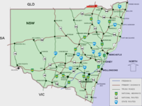
New South Wales is a state of :Australia, located in the east of the country. It is bordered by Queensland, Victoria and South Australia to the north, south and west respectively. To the east, the state is bordered by the Tasman Sea, which forms part of the Pacific Ocean. New South Wales...
, Australia
Australia
Australia , officially the Commonwealth of Australia, is a country in the Southern Hemisphere comprising the mainland of the Australian continent, the island of Tasmania, and numerous smaller islands in the Indian and Pacific Oceans. It is the world's sixth-largest country by total area...
in Moree Plains
Moree Plains
The Shire of Moree Plains, located on the New South Wales side of the border with Queensland, is one of the largest Local Government areas in the State....
Shire. In 2006, the town had a population of 647 people.
The name Boggabilla comes from Gamilaraay
Gamilaraay language
The Gamilaraay or Kamilaroi language is a Pama–Nyungan language of the Wiradhuric subgroup found mostly in South East Australia. It was the traditional language of the Kamilaroi people, but is now moribund—according to Ethnologue, there were only 3 speakers left in 1997...
bagaaybila, literally "full of creeks". The same "creek" element is found in the name of Boggabri
Boggabri, New South Wales
Boggabri is a small town on the Kamilaroi Highway in north-western New South Wales, Australia in Narrabri Shire, between Gunnedah and Narrabri. In 2006, the town had a population of 901 people....
. However Boggabilla is receiving low rainfall which has dried up most of the creeks. This has been very bad for agriculture.
Geography
Boggabilla is located on the Newell HighwayNewell Highway
The Newell Highway is the longest highway in New South Wales, Australia. It runs parallel to the eastern coast about 400 kilometres inland, and is the main inland direct road link from Victoria to Queensland, bypassing the more congested coastal areas of New South Wales...
north of Moree
Moree, New South Wales
Moree is a large town in Moree Plains Shire in northern New South Wales, Australia. It is located on the banks of the Mehi River in the centre of the rich black-soil plains....
. Toomelah Station is within the locality and the town of Goondiwindi
Goondiwindi, Queensland
Goondiwindi is an Australian town of approximately 5,629 people. The town has an annual population growth of 1.4 percent. The name Goondiwindi derives from an Aboriginal word meaning "the resting place of the birds".-History:...
is nearby, across the border in Queensland
Queensland
Queensland is a state of Australia, occupying the north-eastern section of the mainland continent. It is bordered by the Northern Territory, South Australia and New South Wales to the west, south-west and south respectively. To the east, Queensland is bordered by the Coral Sea and Pacific Ocean...
.
Transport
Boggabilla used to have a railway service, but this has been cut back to North Star, New South WalesNorth Star, New South Wales
North Star is a small village in northern New South Wales near the Queensland border. At the 2006 census, North Star had a population of 327 people.- Facilities :* Grain storage capabilities owned by Grain Corp, with access to the railway line....
where the last silo is located. There is also an airport and shuttle services to Sydney.