

Blockade Strategy Board
Encyclopedia
The Blockade Strategy Board of the American Civil War, also known variously as the Commission of Conference or as the Du Pont Board, was a group of four men, meeting in the summer of 1861 at the request of the Navy Department, who laid out a preliminary strategy for enforcing the blockade of seceding states that had been proclaimed by President Abraham Lincoln
. Although the board reported to the Navy Department, only half of its members were sailors. These were Captain Samuel Francis Du Pont
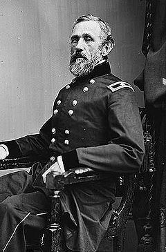
, who acted as chairman, and Commander Charles Henry Davis
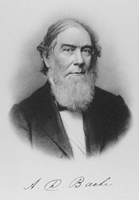
. The other two were Major John Gross Barnard of the US Army and Alexander Dallas Bache
of the US Coast Survey and the Smithsonian Institution. The board considered the entire coast held by the Confederate States of America
, and recommended how best to complete the blockade. Their reports for the Atlantic seaboard were used, with modifications, to direct the early course of the naval war. Their analysis of the Gulf Coast was not so successful, largely because the detailed oceanographic knowledge that marked the Atlantic reports was not available for the Gulf.
, in Charleston Harbor
, was bombarded on 12 April 1861, thereby initiating the American Civil War
. Following the outbreak of hostilities, on 19 April President Lincoln
proclaimed a blockade of all ports in the states that had seceded from the Union at that time; later, after Virginia
and North Carolina
also joined the Confederacy
, his proclamation was modified to include their coastlines as well. The blockade, which existed only on paper at this time, became an integral part of the plan to persuade the seceded states to return to the Union that was proposed by General in Chief Winfield Scott
. Scott's so-called Anaconda Plan
was not formally adopted as an outline strategy to guide the conduct of the war, but the blockade was enforced to the limit of ability of the US Navy as long as the conflict lasted.
 At the start, the Navy was woefully inadequate to the task of blockading the 3000 miles (4800 km) of Southern shoreline. It had only 90 ships of all types, and only 42 that were powered by steam. A frenzied program of shipbuilding and conversions of existing merchant vessels increased the number to 671 by the end of the war, but as they came into service, their assignments had to be prioritized.
The person in Lincoln's cabinet most concerned with rationalizing the blockade was Secretary of the Treasury Salmon P. Chase
. Treasury's Revenue Cutter Service was the agency most familiar with the nation's ports, and the knowledge of harbor bottoms held by its Coast Survey would be needed by the naval commanders who patrolled their waters. He persuaded Secretary of the Navy Gideon Welles
to set up a commission to study the entire Southern coast, and on 25 June 1861 Welles issued the necessary orders to Captain (later Rear Admiral) Samuel Francis Du Pont
. At the same time, he ordered Commander (later Rear Admiral) Charles Henry Davis
to the board to serve as secretary, and requested that Army Major (later Major General) John G. Barnard
, chief of the Army Corps of Engineers, and Alexander D. Bache, Superintendent of the Coast Survey, lend their services. Other persons gave advice, but all reports issued by the commission were signed only by these four.
 The board delivered its first report, dealing with a southern anchor for the Atlantic blockade, on 5 July. It continued to issue reports throughout the summer. These have been published as parts of the Official Records
. Identified by their dates, they are:
 The recommendations of the board for the Atlantic blockade were mostly accepted, with modifications, by the Lincoln administration. The capture of Fernandina, proposed as the initial offensive action of the Union Navy, was postponed until after the capture of Hatteras Island
and Port Royal
. The suggestion that Hatteras Inlet be blocked up was overruled by Flag Officer Silas Stringham
and Brig. General Benjamin F. Butler
, the men who led the expedition. (The board had anticipated that its recommendations would not be followed to the letter. In their report, they included the statement that "These plans may undergo some modification in the hands of the person to whom their execution shall be intrusted.")
The capture of Port Royal Sound
also represented a divergence from the board's original plan. They had stated a preference for an attack on St. Helena Sound, which was nearer to Charleston
and also would have been harder for the Rebels to defend. The natural advantages of Port Royal were so great, however, that the administration chose to take it. Perhaps ironically, Captain (by then Flag Officer) Du Pont was selected to lead the naval contingent in the expedition against the harbor.
The Gulf blockade diverged much further from board plans for several reasons. One of the most important is the lack of knowledge of the Gulf coast compared with the Atlantic. The hydrography was so imperfectly known that one of the board's more emphatic recommendations was that a Coast Survey vessel should be attached to each blockading squadron. (This recommendation was accepted. The Coast Survey proved to be quite useful throughout the war.)
Although Ship Island was taken in accord with the report of 9 August, the Navy Department used it as the staging ground for David G. Farragut's assault on and capture of New Orleans
. The board had opposed any immediate move up the Mississippi River
, not because it would be undesirable, but because they believed that it could not be done with the weapons at hand.
The blockade of the southern extreme of the Texas coast also did not conform to board expectations. The problem there was that the port at Brownsville
, at the mouth of the Rio Grande
, also served the Mexican community of Matamoros
. The international problems associated with the blockade there were exacerbated by the rebellion against the Emperor Maximilian going on in Mexico at the time.
Abraham Lincoln
Abraham Lincoln was the 16th President of the United States, serving from March 1861 until his assassination in April 1865. He successfully led his country through a great constitutional, military and moral crisis – the American Civil War – preserving the Union, while ending slavery, and...
. Although the board reported to the Navy Department, only half of its members were sailors. These were Captain Samuel Francis Du Pont
Samuel Francis du Pont
Samuel Francis Du Pont was an American naval officer who achieved the rank of Rear Admiral in the United States Navy, and a member of the prominent Du Pont family; he was the only member of his generation to use a capital D...
, who acted as chairman, and Commander Charles Henry Davis
Charles Henry Davis
Charles Henry Davis was a Rear Admiral in the United States Navy, serving primarily during the American Civil War, and with the United States Coast Survey.-Early life and career:...
. The other two were Major John Gross Barnard of the US Army and Alexander Dallas Bache
Alexander Dallas Bache
Alexander Dallas Bache was an American physicist, scientist and surveyor who erected coastal fortifications and conducted a detailed survey mapping of the United States coastline.-Biography:...
of the US Coast Survey and the Smithsonian Institution. The board considered the entire coast held by the Confederate States of America
Confederate States of America
The Confederate States of America was a government set up from 1861 to 1865 by 11 Southern slave states of the United States of America that had declared their secession from the U.S...
, and recommended how best to complete the blockade. Their reports for the Atlantic seaboard were used, with modifications, to direct the early course of the naval war. Their analysis of the Gulf Coast was not so successful, largely because the detailed oceanographic knowledge that marked the Atlantic reports was not available for the Gulf.
Origin
Fort SumterFort Sumter
Fort Sumter is a Third System masonry coastal fortification located in Charleston Harbor, South Carolina. The fort is best known as the site upon which the shots initiating the American Civil War were fired, at the Battle of Fort Sumter.- Construction :...
, in Charleston Harbor
Charleston, South Carolina
Charleston is the second largest city in the U.S. state of South Carolina. It was made the county seat of Charleston County in 1901 when Charleston County was founded. The city's original name was Charles Towne in 1670, and it moved to its present location from a location on the west bank of the...
, was bombarded on 12 April 1861, thereby initiating the American Civil War
American Civil War
The American Civil War was a civil war fought in the United States of America. In response to the election of Abraham Lincoln as President of the United States, 11 southern slave states declared their secession from the United States and formed the Confederate States of America ; the other 25...
. Following the outbreak of hostilities, on 19 April President Lincoln
Abraham Lincoln
Abraham Lincoln was the 16th President of the United States, serving from March 1861 until his assassination in April 1865. He successfully led his country through a great constitutional, military and moral crisis – the American Civil War – preserving the Union, while ending slavery, and...
proclaimed a blockade of all ports in the states that had seceded from the Union at that time; later, after Virginia
Virginia
The Commonwealth of Virginia , is a U.S. state on the Atlantic Coast of the Southern United States. Virginia is nicknamed the "Old Dominion" and sometimes the "Mother of Presidents" after the eight U.S. presidents born there...
and North Carolina
North Carolina
North Carolina is a state located in the southeastern United States. The state borders South Carolina and Georgia to the south, Tennessee to the west and Virginia to the north. North Carolina contains 100 counties. Its capital is Raleigh, and its largest city is Charlotte...
also joined the Confederacy
Confederate States of America
The Confederate States of America was a government set up from 1861 to 1865 by 11 Southern slave states of the United States of America that had declared their secession from the U.S...
, his proclamation was modified to include their coastlines as well. The blockade, which existed only on paper at this time, became an integral part of the plan to persuade the seceded states to return to the Union that was proposed by General in Chief Winfield Scott
Winfield Scott
Winfield Scott was a United States Army general, and unsuccessful presidential candidate of the Whig Party in 1852....
. Scott's so-called Anaconda Plan
Anaconda Plan
The Anaconda Plan or Scott's Great Snake is the name widely applied to an outline strategy for subduing the seceding states in the American Civil War. Proposed by General-in-Chief Winfield Scott, the plan emphasized the blockade of the Southern ports, and called for an advance down the Mississippi...
was not formally adopted as an outline strategy to guide the conduct of the war, but the blockade was enforced to the limit of ability of the US Navy as long as the conflict lasted.
The person in Lincoln's cabinet most concerned with rationalizing the blockade was Secretary of the Treasury Salmon P. Chase
Salmon P. Chase
Salmon Portland Chase was an American politician and jurist who served as U.S. Senator from Ohio and the 23rd Governor of Ohio; as U.S. Treasury Secretary under President Abraham Lincoln; and as the sixth Chief Justice of the United States Supreme Court.Chase was one of the most prominent members...
. Treasury's Revenue Cutter Service was the agency most familiar with the nation's ports, and the knowledge of harbor bottoms held by its Coast Survey would be needed by the naval commanders who patrolled their waters. He persuaded Secretary of the Navy Gideon Welles
Gideon Welles
Gideon Welles was the United States Secretary of the Navy from 1861 to 1869. His buildup of the Navy to successfully execute blockades of Southern ports was a key component of Northern victory of the Civil War...
to set up a commission to study the entire Southern coast, and on 25 June 1861 Welles issued the necessary orders to Captain (later Rear Admiral) Samuel Francis Du Pont
Samuel Francis du Pont
Samuel Francis Du Pont was an American naval officer who achieved the rank of Rear Admiral in the United States Navy, and a member of the prominent Du Pont family; he was the only member of his generation to use a capital D...
. At the same time, he ordered Commander (later Rear Admiral) Charles Henry Davis
Charles Henry Davis
Charles Henry Davis was a Rear Admiral in the United States Navy, serving primarily during the American Civil War, and with the United States Coast Survey.-Early life and career:...
to the board to serve as secretary, and requested that Army Major (later Major General) John G. Barnard
John G. Barnard
John Gross Barnard was a career engineering officer in the U.S. Army, serving in the Mexican-American War, as the Superintendent of the United States Military Academy and as a general in the Union Army during the American Civil War...
, chief of the Army Corps of Engineers, and Alexander D. Bache, Superintendent of the Coast Survey, lend their services. Other persons gave advice, but all reports issued by the commission were signed only by these four.
The reports
Official Records of the American Civil War
The Official Records of the War of the Rebellion or often more simply the Official Records or ORs, constitute the most extensive collection of primary sources of the history of the American Civil War. Cornell University lists the official title as, "The War of the Rebellion: a Compilation of the...
. Identified by their dates, they are:
-
- 5 July 1861 — ORN I, volume 12, pages 195–198.
- Deals with Fernandina, Florida and its harbor. Recommends seizing it as the southern anchor to the Atlantic blockading line.
- 13 July 1861 — ORA I, volume 53, pages 67–73.
- Considers the South Carolina coast, particularly Bull's Bay, St. Helena Sound, and Port Royal SoundPort Royal SoundPort Royal Sound is a coastal sound, or inlet of the Atlantic Ocean, located in the Sea Islands region, in Beaufort County in the U.S. state of South Carolina...
. Recommends seizure and occupation of at least one.
- Considers the South Carolina coast, particularly Bull's Bay, St. Helena Sound, and Port Royal Sound
- 16 July 1861 — ORN I, volume 12, pages 198–201.
- Recommends dividing the Atlantic Blockading SquadronAtlantic Blockading SquadronThe Atlantic Blockading Squadron was a unit of the United States Navy created in the early days of the American Civil War to enforce a blockade of the ports of the Confederate States...
in two, to be separated at Cape Romain in South Carolina. Suggests ways to complete blockade between Cape HenryCape HenryCape Henry is a cape on the Atlantic shore of Virginia north of Virginia Beach. It is the southern boundary of the entrance to Chesapeake Bay.Across the mouth of the bay to the north is Cape Charles...
and Cape Romain.
- Recommends dividing the Atlantic Blockading Squadron
- 26 July 1861 — ORN I, volume 12, pages 201–206.
- Deals with the parts of the Atlantic blockade not covered in the reports of 13 and 16 July.
- 9 August 1861 — ORN I, volume 16, pages 618–630.
- Distinguishes six regions of the Gulf coast, and restricts recommendations to the sections covering New OrleansNew Orleans, LouisianaNew Orleans is a major United States port and the largest city and metropolitan area in the state of Louisiana. The New Orleans metropolitan area has a population of 1,235,650 as of 2009, the 46th largest in the USA. The New Orleans – Metairie – Bogalusa combined statistical area has a population...
and MobileMobile, AlabamaMobile is the third most populous city in the Southern US state of Alabama and is the county seat of Mobile County. It is located on the Mobile River and the central Gulf Coast of the United States. The population within the city limits was 195,111 during the 2010 census. It is the largest...
. Suggests that Ship Island be captured as a staging ground for operations against either or both.
- Distinguishes six regions of the Gulf coast, and restricts recommendations to the sections covering New Orleans
- 3 September 1861 — ORN I, volume 16, pages 651–655.
- Deals with Gulf coast other than the parts not considered in report of 9 August.
- 19 September 1861 — ORN I, volume 16, pages 680–681.
- Considers Ship Island and the lower Mississippi RiverMississippi RiverThe Mississippi River is the largest river system in North America. Flowing entirely in the United States, this river rises in western Minnesota and meanders slowly southwards for to the Mississippi River Delta at the Gulf of Mexico. With its many tributaries, the Mississippi's watershed drains...
in greater detail than report of 9 August.
- Considers Ship Island and the lower Mississippi River
- 5 July 1861 — ORN I, volume 12, pages 195–198.
Effect
Battle of Hatteras Inlet Batteries
The Battle of Hatteras Inlet Batteries, sometimes known as the Battle of Forts Hatteras and Clark, was a small but significant engagement in the early days of the American Civil War. Two Confederate forts on the North Carolina Outer Banks were subjected to an amphibious assault by Union forces that...
and Port Royal
Battle of Port Royal
The Battle of Port Royal was one of the earliest amphibious operations of the American Civil War, in which a United States Navy fleet and United States Army expeditionary force captured Port Royal Sound, South Carolina, between Savannah, Georgia and Charleston, South Carolina, on November 7, 1861...
. The suggestion that Hatteras Inlet be blocked up was overruled by Flag Officer Silas Stringham
Silas Stringham
Silas Horton Stringham was an admiral in the United States Navy.-Biography:Born in Middletown, New York, Stringham served in the United States Navy from the War of 1812 through the American Civil War. During the War of 1812, he served in the frigate and took part in the engagements with the...
and Brig. General Benjamin F. Butler
Benjamin Franklin Butler (politician)
Benjamin Franklin Butler was an American lawyer and politician who represented Massachusetts in the United States House of Representatives and later served as the 33rd Governor of Massachusetts....
, the men who led the expedition. (The board had anticipated that its recommendations would not be followed to the letter. In their report, they included the statement that "These plans may undergo some modification in the hands of the person to whom their execution shall be intrusted.")
The capture of Port Royal Sound
Port Royal Sound
Port Royal Sound is a coastal sound, or inlet of the Atlantic Ocean, located in the Sea Islands region, in Beaufort County in the U.S. state of South Carolina...
also represented a divergence from the board's original plan. They had stated a preference for an attack on St. Helena Sound, which was nearer to Charleston
Charleston, South Carolina
Charleston is the second largest city in the U.S. state of South Carolina. It was made the county seat of Charleston County in 1901 when Charleston County was founded. The city's original name was Charles Towne in 1670, and it moved to its present location from a location on the west bank of the...
and also would have been harder for the Rebels to defend. The natural advantages of Port Royal were so great, however, that the administration chose to take it. Perhaps ironically, Captain (by then Flag Officer) Du Pont was selected to lead the naval contingent in the expedition against the harbor.
The Gulf blockade diverged much further from board plans for several reasons. One of the most important is the lack of knowledge of the Gulf coast compared with the Atlantic. The hydrography was so imperfectly known that one of the board's more emphatic recommendations was that a Coast Survey vessel should be attached to each blockading squadron. (This recommendation was accepted. The Coast Survey proved to be quite useful throughout the war.)
Although Ship Island was taken in accord with the report of 9 August, the Navy Department used it as the staging ground for David G. Farragut's assault on and capture of New Orleans
New Orleans, Louisiana
New Orleans is a major United States port and the largest city and metropolitan area in the state of Louisiana. The New Orleans metropolitan area has a population of 1,235,650 as of 2009, the 46th largest in the USA. The New Orleans – Metairie – Bogalusa combined statistical area has a population...
. The board had opposed any immediate move up the Mississippi River
Mississippi River
The Mississippi River is the largest river system in North America. Flowing entirely in the United States, this river rises in western Minnesota and meanders slowly southwards for to the Mississippi River Delta at the Gulf of Mexico. With its many tributaries, the Mississippi's watershed drains...
, not because it would be undesirable, but because they believed that it could not be done with the weapons at hand.
The blockade of the southern extreme of the Texas coast also did not conform to board expectations. The problem there was that the port at Brownsville
Brownsville, Texas
Brownsville is a city in the southernmost tip of the state of Texas, in the United States. It is located on the northern bank of the Rio Grande, directly north and across the border from Matamoros, Tamaulipas, Mexico. Brownsville is the 16th largest city in the state of Texas with a population of...
, at the mouth of the Rio Grande
Rio Grande
The Rio Grande is a river that flows from southwestern Colorado in the United States to the Gulf of Mexico. Along the way it forms part of the Mexico – United States border. Its length varies as its course changes...
, also served the Mexican community of Matamoros
Matamoros, Tamaulipas
Matamoros, officially known as Heroica Matamoros, is a city in the northeastern part of Tamaulipas, in the country of Mexico. It is located on the southern bank of the Rio Grande, directly across the border from Brownsville, Texas, in the United States. Matamoros is the second largest and second...
. The international problems associated with the blockade there were exacerbated by the rebellion against the Emperor Maximilian going on in Mexico at the time.