
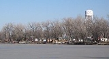
Big Lake, Missouri
Encyclopedia
Big Lake is a village
in Holt County
, Missouri
, United States
. The population was 127 at the 2000 census.
The village is located on the 646 acres (2.6 km²) Big Lake
which is the largest oxbow lake
in Missouri. It is also adjacent to Big Lake State Park
which has the largest marsh in a state park in the state of Missouri.
The actual lake of Big Lake was originally part of the Missouri River
. The lake was formed when the river changed its course leaving a lake behind.
According to the United States Census Bureau
, the village has a total area of 2.7 square miles (7 km²), of which, 1.7 square miles (4.4 km²) of it is land and 1 square miles (2.6 km²) of it (36.23%) is water.
Big Lake is about 10 miles (16.1 km) west of Mound City
on Route 111 off of Route 118.
Big Lake is about ten miles (16 km) from the village of Rulo, Nebraska
.
of 2000, there were 127 people, 60 households, and 37 families residing in the village. The population density
was 75.0 people per square mile (29.0/km²). There were 376 housing units at an average density of 222.0 per square mile (85.9/km²). The racial makeup of the village was 98.43% White, 0.79% Native American, and 0.79% from two or more races.
There were 60 households out of which 10.0% had children under the age of 18 living with them, 56.7% were married couples
living together, 5.0% had a female householder with no husband present, and 36.7% were non-families. 33.3% of all households were made up of individuals and 13.3% had someone living alone who was 65 years of age or older. The average household size was 2.12 and the average family size was 2.45.
In the village the population was spread out with 18.9% under the age of 18, 3.9% from 18 to 24, 15.0% from 25 to 44, 39.4% from 45 to 64, and 22.8% who were 65 years of age or older. The median age was 53 years. For every 100 females there were 95.4 males. For every 100 females age 18 and over, there were 102.0 males.
The median income for a household in the village was $29,583, and the median income for a family was $40,417. Males had a median income of $31,806 versus $21,250 for females. The per capita income
for the village was $27,243. There were 4.7% of families and 5.9% of the population living below the poverty line, including no under eighteens and 11.4% of those over 64.
Village
A village is a clustered human settlement or community, larger than a hamlet with the population ranging from a few hundred to a few thousand , Though often located in rural areas, the term urban village is also applied to certain urban neighbourhoods, such as the West Village in Manhattan, New...
in Holt County
Holt County, Missouri
Holt County is a county located in the U.S. state of Missouri. The county is in the northwest part of the state. As of 2010, the population was 4,912. Its county seat is Oregon. The county was organized in 1841 and is named after the Missouri state legislator Dr...
, Missouri
Missouri
Missouri is a US state located in the Midwestern United States, bordered by Iowa, Illinois, Kentucky, Tennessee, Arkansas, Oklahoma, Kansas and Nebraska. With a 2010 population of 5,988,927, Missouri is the 18th most populous state in the nation and the fifth most populous in the Midwest. It...
, United States
United States
The United States of America is a federal constitutional republic comprising fifty states and a federal district...
. The population was 127 at the 2000 census.
The village is located on the 646 acres (2.6 km²) Big Lake
Big Lake (Missouri)
Big Lake is a oxbow lake in Holt County, Missouri near Big Lake, Missouri.It is believed to have formed from the Missouri River sometime before Lewis & Clark visited the area in 1804. It is the largest oxbow lake in the state of Missouri....
which is the largest oxbow lake
Oxbow lake
An oxbow lake is a U-shaped body of water formed when a wide meander from the main stem of a river is cut off to create a lake. This landform is called an oxbow lake for the distinctive curved shape, named after part of a yoke for oxen. In Australia, an oxbow lake is called a billabong, derived...
in Missouri. It is also adjacent to Big Lake State Park
Big Lake State Park
The Big Lake State Park is located in the Northwest Missouri, United States. The park was established in 1932 around Missouri's largest oxbow lake at Big Lake . Activities at the park include camping, dining, fishing, and swimming.-External links:...
which has the largest marsh in a state park in the state of Missouri.
Geography
Big Lake is located at 40°4′24"N 95°21′3"W (40.073443, -95.350863).The actual lake of Big Lake was originally part of the Missouri River
Missouri River
The Missouri River flows through the central United States, and is a tributary of the Mississippi River. It is the longest river in North America and drains the third largest area, though only the thirteenth largest by discharge. The Missouri's watershed encompasses most of the American Great...
. The lake was formed when the river changed its course leaving a lake behind.
According to the United States Census Bureau
United States Census Bureau
The United States Census Bureau is the government agency that is responsible for the United States Census. It also gathers other national demographic and economic data...
, the village has a total area of 2.7 square miles (7 km²), of which, 1.7 square miles (4.4 km²) of it is land and 1 square miles (2.6 km²) of it (36.23%) is water.
Big Lake is about 10 miles (16.1 km) west of Mound City
Mound City, Missouri
Mound City is a city in Holt County, Missouri, United States. The population was 1,193 at the 2000 census.-Geography:Mound City is located at , at the southern end of the Loess Hills. It is named for the hills in the area...
on Route 111 off of Route 118.
Big Lake is about ten miles (16 km) from the village of Rulo, Nebraska
Rulo, Nebraska
-History:The 'Leary' excavation is the main 'Oneota'- reference to the Missouri River. The Oneota were a 'Mississippi' equal culture that flourished from 1000 to 1650 AD. Oneota are the ancestors of Siouane-speaking tribes. The site is located near present Rulo. Around 1640, the area around the...
.
Demographics
As of the censusCensus
A census is the procedure of systematically acquiring and recording information about the members of a given population. It is a regularly occurring and official count of a particular population. The term is used mostly in connection with national population and housing censuses; other common...
of 2000, there were 127 people, 60 households, and 37 families residing in the village. The population density
Population density
Population density is a measurement of population per unit area or unit volume. It is frequently applied to living organisms, and particularly to humans...
was 75.0 people per square mile (29.0/km²). There were 376 housing units at an average density of 222.0 per square mile (85.9/km²). The racial makeup of the village was 98.43% White, 0.79% Native American, and 0.79% from two or more races.
There were 60 households out of which 10.0% had children under the age of 18 living with them, 56.7% were married couples
Marriage
Marriage is a social union or legal contract between people that creates kinship. It is an institution in which interpersonal relationships, usually intimate and sexual, are acknowledged in a variety of ways, depending on the culture or subculture in which it is found...
living together, 5.0% had a female householder with no husband present, and 36.7% were non-families. 33.3% of all households were made up of individuals and 13.3% had someone living alone who was 65 years of age or older. The average household size was 2.12 and the average family size was 2.45.
In the village the population was spread out with 18.9% under the age of 18, 3.9% from 18 to 24, 15.0% from 25 to 44, 39.4% from 45 to 64, and 22.8% who were 65 years of age or older. The median age was 53 years. For every 100 females there were 95.4 males. For every 100 females age 18 and over, there were 102.0 males.
The median income for a household in the village was $29,583, and the median income for a family was $40,417. Males had a median income of $31,806 versus $21,250 for females. The per capita income
Per capita income
Per capita income or income per person is a measure of mean income within an economic aggregate, such as a country or city. It is calculated by taking a measure of all sources of income in the aggregate and dividing it by the total population...
for the village was $27,243. There were 4.7% of families and 5.9% of the population living below the poverty line, including no under eighteens and 11.4% of those over 64.