

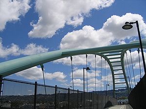
Berkeley I-80 bridge
Encyclopedia
Interstate 580 (California)
Interstate 580 is an 80-mile east–west Interstate Highway in Northern California. The heavily traveled spur route of Interstate 80 runs from San Rafael in the San Francisco Bay Area to Interstate 5 near Tracy in the Central Valley...
) in Berkeley, California
Berkeley, California
Berkeley is a city on the east shore of the San Francisco Bay in Northern California, United States. Its neighbors to the south are the cities of Oakland and Emeryville. To the north is the city of Albany and the unincorporated community of Kensington...
to allow bicycles, pedestrians, and wheelchair users access to the Berkeley Marina
Berkeley Marina
The Berkeley Marina is the westernmost portion of the city of Berkeley, California, located west of the Eastshore Freeway at the foot of University Avenue on San Francisco Bay...
, Eastshore State Park
Eastshore State Park
Eastshore State Park is a state park and wildlife refuge along the San Francisco Bay shoreline of the East Bay between the cities of Richmond, Albany, Berkeley, Emeryville, and Oakland. It encompasses remnant natural wetlands, restored wetlands as well as landfill west of the Eastshore Freeway. It...
, and the city. In the records of the city, the bridge is referred to as the "City of Berkeley Eastshore Pedestrian Overcrossing". The bridge has two lanes for bikes, and a raised sidewalk. It is also wide enough to carry emergency vehicles, if needed.
History
Opened on February 27, 2002, the bridge was built at a cost of $6.4 million. The bridge created an ADA (Americans with Disabilities Act of 1990Americans with Disabilities Act of 1990
The Americans with Disabilities Act of 1990 is a law that was enacted by the U.S. Congress in 1990. It was signed into law on July 26, 1990, by President George H. W. Bush, and later amended with changes effective January 1, 2009....
)-compliant route between Berkeley and its Marina/waterfront park region. Previously, the only wheelchair accessible route was via an undercrossing one mile (1.6 km) to the north. Bicycles and pedestrians could use a dark, hidden, and seldom-used path and stairwell that ran under and along the University Avenue freeway overpass.
Since opening, the bridge has seen a much higher use than the previous path and stairwell.