

Belum Caves
Encyclopedia
Indian subcontinent
The Indian subcontinent, also Indian Subcontinent, Indo-Pak Subcontinent or South Asian Subcontinent is a region of the Asian continent on the Indian tectonic plate from the Hindu Kush or Hindu Koh, Himalayas and including the Kuen Lun and Karakoram ranges, forming a land mass which extends...
and the longest caves in plains of Indian Subcontinent, known for its stalactite
Stalactite
A stalactite , "to drip", and meaning "that which drips") is a type of speleothem that hangs from the ceiling of limestone caves. It is a type of dripstone...
and stalagmite
Stalagmite
A stalagmite is a type of speleothem that rises from the floor of a limestone cave due to the dripping of mineralized solutions and the deposition of calcium carbonate. This stalagmite formation occurs only under certain pH conditions within the underground cavern. The corresponding formation on...
formations. Belum Caves have long passages, spacious chambers, fresh water galleries and siphons. The caves reach its deepest point (120 feet from entrance level) at the point known as Pataalaganga. Belum Caves derives its name from "Bilum" Sanskrit
Sanskrit
Sanskrit , is a historical Indo-Aryan language and the primary liturgical language of Hinduism, Jainism and Buddhism.Buddhism: besides Pali, see Buddhist Hybrid Sanskrit Today, it is listed as one of the 22 scheduled languages of India and is an official language of the state of Uttarakhand...
word for caves. In Telugu language
Telugu language
Telugu is a Central Dravidian language primarily spoken in the state of Andhra Pradesh, India, where it is an official language. It is also spoken in the neighbouring states of Chattisgarh, Karnataka, Maharashtra, Orissa and Tamil Nadu...
, it is called Belum Guhalu. Belum Caves has a length of 3229 metres, making it the second largest natural caves in Indian Subcontinent.
Originally discovered in 1884 by a British surveyor Robert Bruce Foote
Robert Bruce Foote
Robert Bruce Foote was a British geologist and archaeologist who conducted geological surveys of prehistoric locations in India for the Geological Survey of India. In 1863, the year after his archaeological survey began, he discovered the first conclusive Paleolithic stone tool in India. He found...
, later in 1982-84, a team of German speleologists headed by H Daniel Gebauer conducted a detailed exploration of the caves. Thereafter in 1988, the state government
Government of Andhra Pradesh
Government of Andhra Pradesh is the government for the state of Andhra Pradesh in South India.It is an elected government with 294 MLAs elected to the legislative assembly for a 5 year term.-Executive:...
declared them protected, and Andhra Pradesh Tourism Development Corporation
Andhra Pradesh Tourism Development Corporation
Andhra Pradesh Tourism Development Corporation is a state government agency which promotes tourism in Andhra Pradesh, India....
(APTDC) developed the caves as a tourist attraction in February 2002. Today, 3.5 km of the cave has been successfully explored, though only 1.5 km is open to tourists.
The site
Belum Caves is located at Belum Village in KolimigundlaKolimigundla
Kolimigundla is a mandal in Kurnool district of Andhra Pradesh, India.It is located at the trijunction of three districts of kurnool,kadapa and ananthapur.This village is located in Kurnool district.Tadapatri of Anantapur,jammalamadugu of Kadapa. koilkuntla and Banaganapalli of kurnool are nearest...
Mandal of Kurnool District
Kurnool district
Kurnool District is a district in the state of Andhra Pradesh, India, located in the west-central part of the state on the southern banks of the Tungabhadra and Handri rivers. The town of Kurnool is currently the headquarters of the district...
in State of Andhra Pradesh, India. 15.102346°N 78.111541°E Kolimigundla is situated 3 km from Belum Caves.
Discovery
Even though the Belum Caves were known to the locals, the first records of Caves were mentioned in expedition report of Robert Bruce Foote, in 1884. Thereafter, Belum Caves remained unnoticed for almost a century till a German team headed by Herbert Daniel Gebauer conducted detailed exploration of the caves in 1982 and 1983. The German expedition was assisted by the locals Mr B. Chalapathi Reddy, Mr Ramaswami Reddy, Mr Boyu Madduleti, Mr K. Padmanabhaiah, Mr K. Chinnaiah and Mr A. Sunkanna.- 4500 BC Remnants of vessels of that age were found in the caves.
- ???? occupied by Jains and Buddhists.
- 1884 existence of the caves recorded by Mr Robert Bruce Foote.
- 1982 explored by the German Herbert Daniel Gebauer.
- 1983 explored by the German Herbert Daniel Gebauer.
- 1988 declared protected by the Andhra Pradesh Government.
- 1999 development of the cave by Andhra Pradesh Tourism Development Corporation started.
- FEB-2002 cave opened to the public.
- JUL-2002 Musical chamber discovered.
Historical importance
Belum Caves are geologically and historically important caves. There are indications that Jains and Buddhists monks were occupying these caves centuries ago. Many Buddhists relics were found inside the caves. These relics are now housed in Museum at Ananthapur.Archaeological survey of India (ASI) also found remnants of vessels, etc. of pre-Buddhist era and has dated the remnants of vessels found in the caves to 4500 BC.
Development of Caves
The caves was being used to dump wastes of nearby places till 1988. The local people of nearby areas, notably Retired Additional Superintendent of Police M. Narayana Reddy, residents of Belum Village like B. Chalapathi Reddy,B.Maheswara Reddy and others followed up Government of Andhra Pradesh to develop the caves as tourist attraction. Finally their almost two decade long efforts resulted in when Government of Andhra PradeshAndhra Pradesh
Andhra Pradesh , is one of the 28 states of India, situated on the southeastern coast of India. It is India's fourth largest state by area and fifth largest by population. Its capital and largest city by population is Hyderabad.The total GDP of Andhra Pradesh is $100 billion and is ranked third...
declaring entire area to be protected zone. Finally in the year 1999, Andhra Pradesh Tourism Development Corporation
Andhra Pradesh Tourism Development Corporation
Andhra Pradesh Tourism Development Corporation is a state government agency which promotes tourism in Andhra Pradesh, India....
took over the task of beautifying and maintaining the caves. APTDC sanctioned Rs.75,00,000.00 to develop the caves.
The caves are now managed by Andhra Pradesh Tourism Development Corporation (APTDC). Andhra Pradesh Tourism Development Corporation (APTDC) has developed the pathways in around 2 km of the length of the caves, provided soft illumination and has created fresh-air-shafts in the caves. At many places inside the cave, APTDC has installed bridges, staircase, etc. for easy movement inside tha cave. It has also created a canteen, washroom and toilet facilities near the entry point.
There is a giant Buddha Statue near a hillock near the Belum Caves. The area of cave known as "Meditation hall" was used by Buddhist Monks. The relics of Buddhist period were found here. These relics are now housed in museum at Ananthapur.
Main Sections of Belum Caves
- Simhadwaram — Simhadwaram means lions gate. It is a natural arch of stalactites formed in the shape of a lion’s head;
- Kotilingalu Chamber - This section contains stalactite formations which are akin to shiva lingams. This section has thousands of such stalactite giving it a surrealistic look. It has one huge pillar formed due to stalactite and stalagmite joining together.
- Patalaganga - It is a small perennial stream which disappears into the depths of the earth. This stream flows from the southeast to northwest. It disappears and is believed to be heading towards a well at the Belum village, located 2 km away from the caves.
- Saptasvarala Guha or Musical Chamber - Saptasvarala Guha means chamber of seven notes. The stalactite formations in this chamber reproduce musical sounds when these are struck with a wooden stick or knuckles. This section was opened to the public in 2006.
- Dhyan Mandir or Meditation Hall - This section is near to the entrance. An interesting formation at Meditation hall looks like a bed with pillow to recline. The local legend has it that in ancient times many sages use to live here. This section was used by Buddhist Monks. Many relics of Buddhist period were found here which are now housed in museum at Ananthapur.
- Thousand Hoods - This section has amazing stalactite formations shaped like hood of CobraCobraCobra is a venomous snake belonging to the family Elapidae. However, not all snakes commonly referred to as cobras are of the same genus, or even of the same family. The name is short for cobra capo or capa Snake, which is Portuguese for "snake with hood", or "hood-snake"...
. The stalactite formations on the ceiling looks as if thousands of cobras have opened their hoods.
- Banyan Tree Hall - This section has a huge pillar with stalactites hanging from the ceiling. This gives a look of Banyan Tree with its aerial roots when seen from below. The locals call it "Voodalamari" since it looks like a Banyan Tree with its aerial roots hanging from the branches.
- Mandapam - This is a huge area inside the cave with magnificent stalactite structures on the sides giving it a look of a hall with pillars.
Entrance to Caves
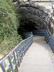
The tourists are charged an amount of Rs.30.00 for entrance. Foreign Tourists are charged Rs.300.00 per person for entrance. APTDC has installed electronic gates at entrance. After passing through the gates, one can reach the caves by a metal staircase installed by APTDC.The entrance pit was originally smaller than what one sees today. It has been broadened as part of development of the caves to install the staircase to allow visitors to descend and ascend easily.
The entrance is like that of a Pit Cave
Pit Cave
A pit cave, or vertical cave — or often simply called a pit or pot — is a type of natural cave which contains one or more significant vertical shafts rather than being predominantly a conventional horizontal cave passage. Pit caves typically form in limestone as a result of long-term erosion by...
. From the ground you can only see two pits side by side and third pit a little further away. After descending around 20 meters by a the stairs from the entrance, the caves become horizontal. The first section one enters is called Gebauer Hall named after Speleologist Mr H. Daniel Gebauer, who had explored and mapped the caves in 1982-1983. The path to Gebauer Hall leads below the second opening, which lies next to the main entrance.
Awards to APTDC for Belum Caves
- In, 2003, APTDC won the prestigious "National Tourism Awards" instituted by Ministry of Tourism and Culture, Government of India, for its initiatives in developing and promoting Belum Caves.
- Belum caves was also adjudged the best destination award 2002 at the Tourism and Travel Fair held in Bangalore in 2002.
Accommodation near Belum Caves
APTDC runs Punnami Hotel in vicinity of Belum Caves. The only accommodation type offered is a 32 beds dormitory. The charges for dormitory accommodation is Rs.40.00 per person. This hotel is planned to be upgraded in future. APTDC also runs a restaurant and a small shop at the entrance to Belum Caves.Nearest towns are Tadipatri (30 km) and Banganpalli (20 km) where one can find hotels to stay. There are no other place nearby where one can find a restaurant or any sort of eating joint. It is advisable to carry bottled drinking water when visiting the caves since it get very hot and humid at certain sections.
Kurnool (106km) and Ananthapur (85 km) are other places to stay and these places have good hotels. Both these places are well connected by road and rail.This cave can also be reached from Nandiyal railway station falling in Guntur-Bangalore section of South Central railway,which is about 60 km away.
Distance from major cities/towns
- 320 km from BangaloreBangaloreBengaluru , formerly called Bengaluru is the capital of the Indian state of Karnataka. Bangalore is nicknamed the Garden City and was once called a pensioner's paradise. Located on the Deccan Plateau in the south-eastern part of Karnataka, Bangalore is India's third most populous city and...
- 320 km from Hyderabad
- 420 km from ChennaiChennaiChennai , formerly known as Madras or Madarasapatinam , is the capital city of the Indian state of Tamil Nadu, located on the Coromandel Coast off the Bay of Bengal. Chennai is the fourth most populous metropolitan area and the sixth most populous city in India...
- 106 km from KurnoolKurnoolKurnool is located at . It has an average elevation of 273 metres .Kurnool lies on the banks of the Tungabhadra River. The Handry and Neeva rivers also flow through the city. The K.C...
- 85 km from Ananthapur
- 30 km from TadpatriTadpatriTadipatri or Tadpatri is a city and a municipality in Anantapur district in the Indian state of Andhra Pradesh.-Geography:Tadipatri is located at . Its average elevation is 223 metres or 731 feet.MLA of Tadipatri is Mr J.C.Divakar Reddy-Demographics:...
- 60 km from NandyalNandyalNandyal or Nandyala is a town in Kurnool District, Andhra Pradesh, India. It is a major centre of trade, commerce, education and industries in the region and is also important because of its religious significance and Rich water resources. The town derives its name from Nandi, the vehicle of...
- 20 km from BanganapalleBanganapalleBanganapalle is a town in the state of Andhra Pradesh, India. It lies in Kurnool district, 70 km south of the town of Kurnool. Banganapalle is famous for its mangoes, commonly called 'Banginpalli variety' and even has a cultivar, Banganapalli, named after it...
- 34 km from koil kuntla
- 44 km from JammalamaduguJammalamaduguJammalamadugu is a town in YSR district of Andhra Pradesh in India. It lies on the left bank of the river Penneru and a reservoir named 'Mylavaram' constructed on this river near this town. And also GANDIKOTA resorvoir loacated near gandikota port. This place, sometimes referred to as...
It is very near to Owk, and adjacent to Belum Village,
External links
- Deccan Herald - Underground adventure in Belum caves
- The Telegraph - Calcutta : Weekend
- cave-biology.org Cave biology (biospeleology) in India.
- Belum Caves collection Flickr