
Bellingham, Tasmania
Encyclopedia
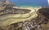
Bellingham is a tiny coastal hamlet in Northern Tasmania
, situated on the mouth of the Pipers River
directly opposite the town of Weymouth
. The town is located 62 kilometres (39 mi) from Launceston
, 20 kilometres (12 mi) from Bridport
and 40 kilometres (25 mi) from George Town
. At the 2006 census
, Bellingham and the surrounding area had a population of 264.
 The township is largely made up of shacks used during the summer time. The permanent residence is about 25 people. In recent years the George Town Council
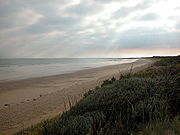
has completed upgrade projects on many of the township's roads, including sealing works on the main Bellingham Road as well as base graveling on Gees Marsh Road, allowing better access to the central township and surrounding areas.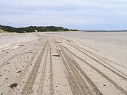 There is a camping ground, tennis court and small boat ramp within the central township, The Marine and Safety Board of Tasmania (MAST) recently announcing funding for a much-needed upgrade for the ramp. the nearby shoreline of the Pipers River can easily be accessed from the town, as well as large coastal beaches adjacent to Bass Strait.
Miller's Beach can be accessed by Four-wheel drive from Gees Marsh Road and marks the beginning of a designated 4wd route that traverses the beaches and sand dunes of Noland Bay and St. Albans Bay, before arriving at Briport. http://www.parks.tas.gov.au/recreation/4wd/4wdtour.html#14b
Originally called Pipers Heads, Bellingham was first used as a watch for sailing vessels that went up the Pipers River to Weymouth. The wharf at Weymouth was burnt down at the turn of the century, leaving a number burnt pilons in the river sand that remain to this day.
altered Crown Land
arrangements in the nearby Gees Marsh hamlet, just east of the main township, so that certain shack owners were allowed to buy the previously public-hold land on which their shacks were located. Unfortunately, some shacks were declared unsafe and were forcibly demolished, creating anger amongst local shack owners, many of whom had used these shacks for generations. Shacks such as "Ghost Shack", a landmark that was brought to her present location in 1939 on a sledge at lower Gees Marsh road, as well as "Butterworths Shack", which was originally built in the 1920s before being extended and later abandoned, falling to vandalism and disrepair in recent years, were amongst those that were removed.
Decisions made by the George Town Council to demolish local community halls and other public facilities in the township, due to disrepair and unsustainable insurance costs, have also created controversy. Local and transient-summer residents have actively campaigned against the decisions and have requested that the Council maintain funding and upgrade the facilities to an acceptable level. Suggestions include the construction of new toilet facilities and disabled access ramps.
Tasmania
Tasmania is an Australian island and state. It is south of the continent, separated by Bass Strait. The state includes the island of Tasmania—the 26th largest island in the world—and the surrounding islands. The state has a population of 507,626 , of whom almost half reside in the greater Hobart...
, situated on the mouth of the Pipers River
Pipers River, Tasmania
Pipers River is a river which flows through northern Tasmania. It starts on Mount Arthur, near Lilydale. It runs through Hollybank Forest, a tourist attraction, before flowing through the outer reaches of Lilydale. It then proceeds through to Karoola, Lower Turners Marsh and then Pipers River town...
directly opposite the town of Weymouth
Weymouth, Tasmania
Weymouth is a small township in northern Tasmania, Australia. Located on the Pipers River opposite Bellingham and about 60 km from Launceston. It has a very small permanent population; however, it attracts many visitors during the summer months. Weymouth has a beach, a tennis court and a seasonal...
. The town is located 62 kilometres (39 mi) from Launceston
Launceston, Tasmania
Launceston is a city in the north of the state of Tasmania, Australia at the junction of the North Esk and South Esk rivers where they become the Tamar River. Launceston is the second largest city in Tasmania after the state capital Hobart...
, 20 kilometres (12 mi) from Bridport
Bridport, Tasmania
Bridport is a small town on the north-east coast of Tasmania, Australia. It is part of the Dorset Council. At the 2006 census, Bridport had a population of 1,327....
and 40 kilometres (25 mi) from George Town
George Town, Tasmania
George Town is one of the larger towns in north-east Tasmania, on the eastern bank of the mouth of the Tamar River. At the 2006 census, George Town had a population of 4,266. It is the regional centre of the George Town Council Local Government Area....
. At the 2006 census
Census in Australia
The Australian census is administered once every five years by the Australian Bureau of Statistics. The most recent census was conducted on 9 August 2011; the next will be conducted in 2016. Prior to the introduction of regular censuses in 1961, they had also been run in 1901, 1911, 1921, 1933,...
, Bellingham and the surrounding area had a population of 264.
Description & History
George Town, Tasmania
George Town is one of the larger towns in north-east Tasmania, on the eastern bank of the mouth of the Tamar River. At the 2006 census, George Town had a population of 4,266. It is the regional centre of the George Town Council Local Government Area....
has completed upgrade projects on many of the township's roads, including sealing works on the main Bellingham Road as well as base graveling on Gees Marsh Road, allowing better access to the central township and surrounding areas.
Miller's Beach can be accessed by Four-wheel drive from Gees Marsh Road and marks the beginning of a designated 4wd route that traverses the beaches and sand dunes of Noland Bay and St. Albans Bay, before arriving at Briport. http://www.parks.tas.gov.au/recreation/4wd/4wdtour.html#14b
Originally called Pipers Heads, Bellingham was first used as a watch for sailing vessels that went up the Pipers River to Weymouth. The wharf at Weymouth was burnt down at the turn of the century, leaving a number burnt pilons in the river sand that remain to this day.
Controversies
Recently, the Tasmanian GovernmentGovernment of Tasmania
The form of the Government of Tasmania is prescribed in its Constitution, which dates from 1856, although it has been amended many times since then...
altered Crown Land
Crown land
In Commonwealth realms, Crown land is an area belonging to the monarch , the equivalent of an entailed estate that passed with the monarchy and could not be alienated from it....
arrangements in the nearby Gees Marsh hamlet, just east of the main township, so that certain shack owners were allowed to buy the previously public-hold land on which their shacks were located. Unfortunately, some shacks were declared unsafe and were forcibly demolished, creating anger amongst local shack owners, many of whom had used these shacks for generations. Shacks such as "Ghost Shack", a landmark that was brought to her present location in 1939 on a sledge at lower Gees Marsh road, as well as "Butterworths Shack", which was originally built in the 1920s before being extended and later abandoned, falling to vandalism and disrepair in recent years, were amongst those that were removed.
Decisions made by the George Town Council to demolish local community halls and other public facilities in the township, due to disrepair and unsustainable insurance costs, have also created controversy. Local and transient-summer residents have actively campaigned against the decisions and have requested that the Council maintain funding and upgrade the facilities to an acceptable level. Suggestions include the construction of new toilet facilities and disabled access ramps.