

Bekal Fort
Encyclopedia
'Bekal Fort' is the largest fort in Kasargod
, Kerala
, India
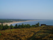
, spreading over 40 acres (161,874.4 m²). An important features of this fort are the water-tank with its flight of steps, the tunnel opening towards the south, the magazine for keeping ammunition and the broad and wide steps leading to the Observation Tower which is a rarity. From there one has ample view of towns in the vicinity like Kanhangad
, Pallikare, Bekal, Kottikkulam, Uduma etc. The nearest railway stations are Pallikare, Kotikulam, Kanhangad,and Kasargod.This observation center had strategic significance in discovering even the smallest movements of the enemy and ascertaining safety of the Fort.
The Fort appears to have been built up from the sea since almost three fourth of its exteriors is drenched and the waves continually stroke the citadel. The Mukhyaprana Temple of Hanuman
and the ancient Muslim Mosque nearby bear testimony to the age-old religious harmony that prevailed in the area. The zigzag entrance and the trenches around the fort show the defense strategy inherent in the fort.
Unlike most other Indian Forts, Bekal fort was not a center of administration for no remains of any palace, mansion or such buildings are found within the fort. Arguably the fort was built exclusively for fulfilling defense requirements. The holes on the outer walls of the fort are specially designed to defend the fort effectively. The holes at top were meant for aiming at the farthest points; the holes below for striking when the enemy was nearer and the holes underneath facilitated attacking when the enemy was very near to the fort. This is a remarkable evidence of technology in defense strategy.
 During the Perumal Age Bekal was a part of Mahodayapuram. The Kodavalam inscription (Pullur, 7 km from Kanhangad) of Bhasakara Ravi II (the King of Mahodayapuram) illustrate the undisputed political sway of Mahodayapuram over this region. Following the political decline of Mahodayapuram Perumals by the 12th century AD, North Kerala including Bekal, came under the sovereignty of Mushika
or Kolathiri
or Chirakkal
Royal Family (who were a secondary royal family at that point to the Cheras
, Pandyas and Cholas). The maritime importance of Bekal increased much under the Kolathiris and it became an important port town of Tulunadu and Malabar.
It was usual in older days for every royal palace to be protected by a fort. The Bekal fort might have, therefore, existed even from early days of the Chirakkal Rajas. While writing a description of the Kolathiri Kingdom in his Kerala History, K.P. Padmanabha Menon writes: "The eldest of the male members reigned as sovereign Kolathiri. The next in succession, the heir apparent, was the Thekkelamkur. The residence assigned to him was the Vadakara fort. The third in succession was the Vadakkelamkur in charge of Vekkolath fort. This V(B)ekkolath fort is identified by some scholars as the present Bekal."
H.A. Stuart, in his Handbook of South Canara (1985), makes this observation: "Several forts were built by the Shivappa Nayaks of Badnore between 1650 and 1670. The two forts of Bekal and Chandragiri were originally under the Kolathiri or Chirakkal Rajas until the time of Shivappa Nayaka's invasion. Perhaps, the Bednore rulers might have rebuilt and improved it."
The Battle of Talikota
in 1565 led to the decline of the mighty Vijayanagara Empire
and many feudatory chieftains rose in political prominence including the Keladi Nayaka
s (Ikkeri Nayaks). The Nayakas realized the political and economic importance of Tulunadu (which is the region comprising modern-day Udupi and Dakshina Kannada
districts along with the Northernmost part of Kasargod District ) and attacked and annexed the region. Bekal served as a nucleus in establishing the dominance of the Nayakas in Malabar. The economic importance of the port town prompted the Nayakas to fortify Bekal subsequently. Hiriya Venkatappa Nayaka initiated the construction of the fort and it was completed during the period of Shivappa Nayaka
. The speedy completion of the port was aimed at the defense of the fort from overseas attack and to strengthen their attack on Malabar. Chandragiri fort
near Kasargod was also constructed during this period.
Somashekhara Nayak captured Manjeswar and Taliparamba
and built a fort at Kanhangad
called Hosdurg which literally means 'New Fort' in Kannada
/Tulu
. The other forts found in Kasargod
are constructed on the coastal region and on the route to Madikeri (Mercara in Coorg). It is believed that the 'Koteyar'/'Ramakshatriya
' community found in Bekal, Panayal and other places in Kasargod were brought to this land by the Nayaks to strengthen and defend the fort. There was a prolonged struggle between the Kolathiries and Nayaks to recapture and maintain their hold over this area. These battles came to an end with the rise of Hyder Ali
who conquered the Nayakas. Subsequently Bekal fell into the hands of Mysore kings
.
 Bekal served as an important military station of Tipu Sultan
when he led the great military expedition to capture Malabar
. The coins and other artifacts unearthed by the archaeological excavation conducted recently at Bekal fort is a manifestation of the strong presence of the Mysore Sulthans. The death of Tipu Sulthan in Fourth Anglo-Mysore War
in 1799 saw the end of Mysorean control and subsequently the fort came under the British East India Company
.
During the reign of the Company Bekal became the headquarters of the newly organized Bekal Taluk of South Canara
District in Bombay presidency. South Canara became a part of the Madras presidency in 1799 and Kasargod Taluk was up in the place of Bekal Taluk. Gradually the political and economic importance of Bekal and its port declined considerably. Kasargod became part of Kerala with the state reorganization in 1956.
Its solid construction resembles the St. Angelo Fort at Kannur
built by Portuguese and also the Thalassery
Fort. The Ikkeri Nayakas had not developed guns to defend themselves from the invaders approaching from the Arabean sea route. But the western part of the fort is built in a solid manner with numerous slits on the walls for defending the fort from the naval power of other rulers. So it is believed that the present look of fort was the outcome of the conflict between European powers. Modification to the fort was made by all the rulers who ruled the land from before the time of the Ikkeri Nayakas. Moreover a number of forts built by the Ikkeri Nayakas have failed to stand the test of time and perished. Located at the centre of the fort is an Observation Tower built by Tipu Sultan
, which offers a breathtaking view of the coastline. Also in existence is a rest-house built by the British Government. Presently the protection and preservation of Bekal fort has been entrusted to the Archaeological Survey of India.
Kasaragod district
Kasaragod District is one of the districts of the Indian state of Kerala. Kasaragod District was organised as a separate district on 24 May 1984...
, Kerala
Kerala
or Keralam is an Indian state located on the Malabar coast of south-west India. It was created on 1 November 1956 by the States Reorganisation Act by combining various Malayalam speaking regions....
, India
India
India , officially the Republic of India , is a country in South Asia. It is the seventh-largest country by geographical area, the second-most populous country with over 1.2 billion people, and the most populous democracy in the world...
, spreading over 40 acres (161,874.4 m²). An important features of this fort are the water-tank with its flight of steps, the tunnel opening towards the south, the magazine for keeping ammunition and the broad and wide steps leading to the Observation Tower which is a rarity. From there one has ample view of towns in the vicinity like Kanhangad
Kanhangad
Kanhangad is a town and a municipality in Kasaragod district in the Indian state of Kerala. It is 28 km from the district headquarters of Kasaragod. Bekal Fort is a 300-year old fort, one of the largest and best preserved forts in Kerala and lies 10 km north of Kanhangad. The fort is...
, Pallikare, Bekal, Kottikkulam, Uduma etc. The nearest railway stations are Pallikare, Kotikulam, Kanhangad,and Kasargod.This observation center had strategic significance in discovering even the smallest movements of the enemy and ascertaining safety of the Fort.
The Fort appears to have been built up from the sea since almost three fourth of its exteriors is drenched and the waves continually stroke the citadel. The Mukhyaprana Temple of Hanuman
Hanuman
Hanuman , is a Hindu deity, who is an ardent devotee of Rama, a central character in the Indian epic Ramayana and one of the dearest devotees of lord Rama. A general among the vanaras, an ape-like race of forest-dwellers, Hanuman is an incarnation of the divine and a disciple of Lord Rama in the...
and the ancient Muslim Mosque nearby bear testimony to the age-old religious harmony that prevailed in the area. The zigzag entrance and the trenches around the fort show the defense strategy inherent in the fort.
Unlike most other Indian Forts, Bekal fort was not a center of administration for no remains of any palace, mansion or such buildings are found within the fort. Arguably the fort was built exclusively for fulfilling defense requirements. The holes on the outer walls of the fort are specially designed to defend the fort effectively. The holes at top were meant for aiming at the farthest points; the holes below for striking when the enemy was nearer and the holes underneath facilitated attacking when the enemy was very near to the fort. This is a remarkable evidence of technology in defense strategy.
Recorded History
Mushika Kingdom
Mushika Kingdom was an ancient kingdom of the Tamil Sangam age in present day northern Kerala, India ruled by the Royal dynasty of the same name. They ruled the strip of land between Mangaluru in the north and Vadagara in the south...
or Kolathiri
Kolathiri
Kolathiri or Kolathiri Rājā was the title by which the senior most male along the matilinial line of the Mushika or Kolathunādu Royal Family was styled...
or Chirakkal
Chirakkal Raja
Chirakkal Raja is the title of the senior most king of the Chirakkal branch of the Palli division of the Kolathiri dynasty of the erstwhile feudal state of Kolathunadu in North Malabar, Kerala state, South India. Chirakkal Rajas and Kolathiris traces their ancestry back to the Mushika dynasty of...
Royal Family (who were a secondary royal family at that point to the Cheras
Chera dynasty
Chera Dynasty in South India is one of the most ancient ruling dynasties in India. Together with the Cholas and the Pandyas, they formed the three principle warring Iron Age Tamil kingdoms in southern India...
, Pandyas and Cholas). The maritime importance of Bekal increased much under the Kolathiris and it became an important port town of Tulunadu and Malabar.
It was usual in older days for every royal palace to be protected by a fort. The Bekal fort might have, therefore, existed even from early days of the Chirakkal Rajas. While writing a description of the Kolathiri Kingdom in his Kerala History, K.P. Padmanabha Menon writes: "The eldest of the male members reigned as sovereign Kolathiri. The next in succession, the heir apparent, was the Thekkelamkur. The residence assigned to him was the Vadakara fort. The third in succession was the Vadakkelamkur in charge of Vekkolath fort. This V(B)ekkolath fort is identified by some scholars as the present Bekal."
H.A. Stuart, in his Handbook of South Canara (1985), makes this observation: "Several forts were built by the Shivappa Nayaks of Badnore between 1650 and 1670. The two forts of Bekal and Chandragiri were originally under the Kolathiri or Chirakkal Rajas until the time of Shivappa Nayaka's invasion. Perhaps, the Bednore rulers might have rebuilt and improved it."
The Battle of Talikota
Battle of Talikota
The Battle of Talikota , a watershed battle fought between the Vijayanagara Empire and the Deccan sultanates, resulted in a rout of Vijayanagara, and ended the last great Hindu kingdom in South India...
in 1565 led to the decline of the mighty Vijayanagara Empire
Vijayanagara Empire
The Vijayanagara Empire , referred as the Kingdom of Bisnaga by the Portuguese, was an empire based in South Indian in the Deccan Plateau region. It was established in 1336 by Harihara I and his brother Bukka Raya I of the Yadava lineage. The empire rose to prominence as a culmination of attempts...
and many feudatory chieftains rose in political prominence including the Keladi Nayaka
Keladi Nayaka
Keladi Nayaka Kingdom were an important ruling dynasty of post-medieval Karnataka, India. They initially started to rule as a feudatory of the Vijayanagar Empire...
s (Ikkeri Nayaks). The Nayakas realized the political and economic importance of Tulunadu (which is the region comprising modern-day Udupi and Dakshina Kannada
Dakshina Kannada
- Geography :The district geography consists of sea shore in the west and Western Ghats in the east. The major rivers are Netravathi, Kumaradhara, Phalguni, Shambhavi, Nandini or Pavanje and Payaswini which all join Arabian sea. Vast areas of evergreen forests which once covered this district, have...
districts along with the Northernmost part of Kasargod District ) and attacked and annexed the region. Bekal served as a nucleus in establishing the dominance of the Nayakas in Malabar. The economic importance of the port town prompted the Nayakas to fortify Bekal subsequently. Hiriya Venkatappa Nayaka initiated the construction of the fort and it was completed during the period of Shivappa Nayaka
Shivappa Nayaka
Shivappa Nayaka , also known as Keladi Shivappa Nayaka, was a notable ruler of the Keladi Nayaka Kingdom. The Keladi Nayakas were successors of the Vijayanagara Empire in the coastal and Malnad districts of Karnataka, India, in the late 16th century...
. The speedy completion of the port was aimed at the defense of the fort from overseas attack and to strengthen their attack on Malabar. Chandragiri fort
Chandragiri fort
Chandragiri Fort built in the 17th [century] is in Kasargod District of Kerala, south India.This large squarish fort is above sea level and occupies an area of about seven acres by the side of the river Payaswini...
near Kasargod was also constructed during this period.
Somashekhara Nayak captured Manjeswar and Taliparamba
Taliparamba
Taliparamba is a city and a municipality in Kannur district in the Indian state of Kerala and spread over an area of 43.05 km2. It stretches from the coastal area of Ramanthali to Nuchiyard and Vayathur villages, touching the Karnataka border.Taliparamba is a big town of 67,000 people...
and built a fort at Kanhangad
Kanhangad
Kanhangad is a town and a municipality in Kasaragod district in the Indian state of Kerala. It is 28 km from the district headquarters of Kasaragod. Bekal Fort is a 300-year old fort, one of the largest and best preserved forts in Kerala and lies 10 km north of Kanhangad. The fort is...
called Hosdurg which literally means 'New Fort' in Kannada
Kannada language
Kannada or , is a language spoken in India predominantly in the state of Karnataka. Kannada, whose native speakers are called Kannadigas and number roughly 50 million, is one of the 30 most spoken languages in the world...
/Tulu
Tulu language
The Tulu language |?]]]) is a Dravidian language spoken by 1.95 million native speakers mainly in the southwest part of Indian state Karnataka known as Tulu Nadu. In India, 1.72 million people speak it as their mother tongue , increased by 10 percent over the 1991 census...
. The other forts found in Kasargod
Kasaragod district
Kasaragod District is one of the districts of the Indian state of Kerala. Kasaragod District was organised as a separate district on 24 May 1984...
are constructed on the coastal region and on the route to Madikeri (Mercara in Coorg). It is believed that the 'Koteyar'/'Ramakshatriya
Ramakshatriya
Ramakshatriyas are a Kannada/Konkani speaking community of former royal army officials/caretaker-administrators of forts who mainly hail from the region of Dakshina Kannada, Udupi, Shimoga, Uttara Kannada Districts of Karnataka and Kasaragod, Kanhangad areas of Kerala, and in the area of Goa...
' community found in Bekal, Panayal and other places in Kasargod were brought to this land by the Nayaks to strengthen and defend the fort. There was a prolonged struggle between the Kolathiries and Nayaks to recapture and maintain their hold over this area. These battles came to an end with the rise of Hyder Ali
Hyder Ali
Hyder Ali was the de facto ruler of the Kingdom of Mysore in southern India. Born Hyder Naik, he distinguished himself militarily, eventually drawing the attention of Mysore's rulers...
who conquered the Nayakas. Subsequently Bekal fell into the hands of Mysore kings
Kingdom of Mysore
The Kingdom of Mysore was a kingdom of southern India, traditionally believed to have been founded in 1399 in the vicinity of the modern city of Mysore. The kingdom, which was ruled by the Wodeyar family, initially served as a vassal state of the Vijayanagara Empire...
.
Tipu Sultan
Tipu Sultan , also known as the Tiger of Mysore, was the de facto ruler of the Kingdom of Mysore. He was the son of Hyder Ali, at that time an officer in the Mysorean army, and his second wife, Fatima or Fakhr-un-Nissa...
when he led the great military expedition to capture Malabar
Malabar Coast
The Malabar Coast is a long and narrow coastline on the south-western shore line of the mainland Indian subcontinent. Geographically, it comprises the wettest regions of southern India, as the Western Ghats intercept the moisture-laden monsoon rains, especially on their westward-facing mountain...
. The coins and other artifacts unearthed by the archaeological excavation conducted recently at Bekal fort is a manifestation of the strong presence of the Mysore Sulthans. The death of Tipu Sulthan in Fourth Anglo-Mysore War
Fourth Anglo-Mysore War
The Fourth Anglo-Mysore War was a war in South India between the Sultanate of Mysore and the British East India Company under the Earl of Mornington....
in 1799 saw the end of Mysorean control and subsequently the fort came under the British East India Company
British East India Company
The East India Company was an early English joint-stock company that was formed initially for pursuing trade with the East Indies, but that ended up trading mainly with the Indian subcontinent and China...
.
During the reign of the Company Bekal became the headquarters of the newly organized Bekal Taluk of South Canara
Dakshina Kannada
- Geography :The district geography consists of sea shore in the west and Western Ghats in the east. The major rivers are Netravathi, Kumaradhara, Phalguni, Shambhavi, Nandini or Pavanje and Payaswini which all join Arabian sea. Vast areas of evergreen forests which once covered this district, have...
District in Bombay presidency. South Canara became a part of the Madras presidency in 1799 and Kasargod Taluk was up in the place of Bekal Taluk. Gradually the political and economic importance of Bekal and its port declined considerably. Kasargod became part of Kerala with the state reorganization in 1956.
Its solid construction resembles the St. Angelo Fort at Kannur
Kannur
Kannur , also known as Cannanore, is a city in Kannur district in the Indian state of Kerala. It is the administrative headquarters of the District of Kannur and 518km north of state capital Trivandrum. During British rule in India, Kannur was known by its old name Cannanore, which is still in...
built by Portuguese and also the Thalassery
Thalassery
Thalassery , also known as Tellicherry, is a city on the Malabar Coast of Kerala, India. This is the second largest city of North Malabar in terms of population. The name Tellicherry is the anglicized form of Thalassery. Thalassery municipality has a population just less than 100,000. Established...
Fort. The Ikkeri Nayakas had not developed guns to defend themselves from the invaders approaching from the Arabean sea route. But the western part of the fort is built in a solid manner with numerous slits on the walls for defending the fort from the naval power of other rulers. So it is believed that the present look of fort was the outcome of the conflict between European powers. Modification to the fort was made by all the rulers who ruled the land from before the time of the Ikkeri Nayakas. Moreover a number of forts built by the Ikkeri Nayakas have failed to stand the test of time and perished. Located at the centre of the fort is an Observation Tower built by Tipu Sultan
Tipu Sultan
Tipu Sultan , also known as the Tiger of Mysore, was the de facto ruler of the Kingdom of Mysore. He was the son of Hyder Ali, at that time an officer in the Mysorean army, and his second wife, Fatima or Fakhr-un-Nissa...
, which offers a breathtaking view of the coastline. Also in existence is a rest-house built by the British Government. Presently the protection and preservation of Bekal fort has been entrusted to the Archaeological Survey of India.
Tourism
Tourism promotion activities have been taking place of late in the areas surrounding the fort, under the Bekal Resorts Development Corporation (BRDC), which is an initiative by the Government of Kerala. The song 'Uyire' (Tamil) 'Bombay' directed by Mani Ratnam has been shot at Bekal Fort. Many such films, music albums, commercial advertisements etc., are being shot at Bekal Fort.How to reach there
- Nearest towns are KanhangadKanhangadKanhangad is a town and a municipality in Kasaragod district in the Indian state of Kerala. It is 28 km from the district headquarters of Kasaragod. Bekal Fort is a 300-year old fort, one of the largest and best preserved forts in Kerala and lies 10 km north of Kanhangad. The fort is...
– 8 km and Kasargod 18 km.- These towns are well connected to nearby cities by bus and train.
- Nearest airports
- Mangalore International AirportMangalore International AirportMangalore Airport, formerly known as Bajpe Airport, is a domestic and customs airport serving the coastal city of Mangalore, India...
– 60 km. - KaripurKaripurKaripur is a small town in Malappuram district of Kerala, south India. The place is best known as the site of the international airport of Kozhikode , serving the needs of travellers in the north Kerala region....
International Airport – 180 km.
- Mangalore International Airport