

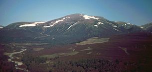
Beinn a' Bhùird
Encyclopedia
Munro
A Munro is a mountain in Scotland with a height over . They are named after Sir Hugh Munro, 4th Baronet , who produced the first list of such hills, known as Munros Tables, in 1891. A Munro top is a summit over 3,000 ft which is not regarded as a separate mountain...
in the Cairngorm
Cairngorms
The Cairngorms are a mountain range in the eastern Highlands of Scotland closely associated with the mountain of the same name - Cairn Gorm.-Name:...
mountain range of Scotland
Scotland
Scotland is a country that is part of the United Kingdom. Occupying the northern third of the island of Great Britain, it shares a border with England to the south and is bounded by the North Sea to the east, the Atlantic Ocean to the north and west, and the North Channel and Irish Sea to the...
.
In Watson (1975) the author suggests the mountain should be named Beinn Bòrd - table hill saying that local Scottish Gaelic speakers pronounced the mountain Paing Bòrd, with some of the older local folk still using Painna Bòrd.
The closest 'village' to Beinn a' Bhùird is Braemar
Braemar
Braemar is a village in Aberdeenshire, Scotland, around west of Aberdeen in the Highlands. It is the closest significantly-sized settlement to the upper course of the River Dee sitting at an altitude of ....
, Aberdeenshire
Aberdeenshire
Aberdeenshire is one of the 32 unitary council areas in Scotland and a lieutenancy area.The present day Aberdeenshire council area does not include the City of Aberdeen, now a separate council area, from which its name derives. Together, the modern council area and the city formed historic...
and the most common approach by car is through this village. To reach Beinn a' Bhùird by car, the most common approach is by the Linn of Dee road along the south side of the River Dee to the Linn of Dee, looping back along the north-bank to the car park at Allanaquoich
Allanaquoich
Allanaquoich is a locality on Mar Lodge Estate, Aberdeenshire, Scotland.Allanaquoich is little more than a farm house now although it once could have been described as a hamlet...
where camping is permitted. The distance between Braemar and Allanaquoich by this route is about 10 miles.
In 2006 a glider pilot from Deeside Gliding Club crashed on the hillside, spending 24 hours trapped in his plane before he was located by the RAF.
Ascents
The usual ascent of Beinn a' Bhùird is from the car park at AllanaquoichAllanaquoich
Allanaquoich is a locality on Mar Lodge Estate, Aberdeenshire, Scotland.Allanaquoich is little more than a farm house now although it once could have been described as a hamlet...
walking up Glen Quoich and following the new path along the line of the old land rover road up An Diollaid.
An alternate ascent follows the Quoich Water through the Am Beitheachan to the bealach named The Sneck - Watson (1975) (and the 1:25000 series Ordnance Survey
Ordnance Survey
Ordnance Survey , an executive agency and non-ministerial government department of the Government of the United Kingdom, is the national mapping agency for Great Britain, producing maps of Great Britain , and one of the world's largest producers of maps.The name reflects its creation together with...
maps) - between Beinn a' Bhùird and Ben Avon
Ben Avon
Ben Avon is a mountain in the Cairngorm mountains of Scotland. The highest point of the massif, known as Leabaidh an Dàimh Bhuide is classified as both a Munro and a Marilyn....
.