
Bayard, West Virginia
Encyclopedia
Bayard is a town in Grant County
, West Virginia
, United States
. The population was 299 at the 2000 census. Bayard was incorporated in 1893 and named in honor of Thomas F. Bayard, Jr.
, who later became a United States Senator from Delaware
(1923–1929). Bayard was founded on the West Virginia Central and Pittsburgh Railroad as a coal mining
community. Coal mining has remained the town's chief industry.
According to the United States Census Bureau
, the town has a total area of 0.3 square miles (0.8 km²), all land.
of 2000, there were 299 people, 141 households, and 93 families residing in the town. The population density
was 949.2 inhabitants per square mile (372.4/km²). There were 172 housing units at an average density of 546.0 per square mile (214.2/km²). The racial makeup of the town was 96.66% White, 0.67% African American, 2.01% Native American, and 0.67% from two or more races. Hispanic or Latino of any race were 0.67% of the population.
There were 141 households out of which 21.3% had children under the age of 18 living with them, 50.4% were married couples
living together, 9.9% had a female householder with no husband present, and 34.0% were non-families. 29.8% of all households were made up of individuals and 18.4% had someone living alone who was 65 years of age or older. The average household size was 2.12 and the average family size was 2.60.
In the town the population was spread out with 16.4% under the age of 18, 9.4% from 18 to 24, 21.7% from 25 to 44, 32.1% from 45 to 64, and 20.4% who were 65 years of age or older. The median age was 46 years. For every 100 females there were 104.8 males. For every 100 females age 18 and over, there were 101.6 males.
The median income for a household in the town was $25,156, and the median income for a family was $31,750. Males had a median income of $30,313 versus $14,583 for females. The per capita income
for the town was $13,882. About 7.2% of families and 14.3% of the population were below the poverty line, including 22.5% of those under the age of eighteen and 5.3% of those sixty five or over.
Grant County, West Virginia
As of the census of 2000, there were 11,299 people, 4,591 households, and 3,273 families residing in the county. The population density was 24 people per square mile . There were 6,105 housing units at an average density of 13 per square mile...
, West Virginia
West Virginia
West Virginia is a state in the Appalachian and Southeastern regions of the United States, bordered by Virginia to the southeast, Kentucky to the southwest, Ohio to the northwest, Pennsylvania to the northeast and Maryland to the east...
, United States
United States
The United States of America is a federal constitutional republic comprising fifty states and a federal district...
. The population was 299 at the 2000 census. Bayard was incorporated in 1893 and named in honor of Thomas F. Bayard, Jr.
Thomas F. Bayard, Jr.
Thomas Francis Bayard, Jr. was an American lawyer and politician from Wilmington, in New Castle County, Delaware. He was a member of the Democratic Party, who served two terms as U.S. Senator from Delaware.-Early life and family:...
, who later became a United States Senator from Delaware
Delaware
Delaware is a U.S. state located on the Atlantic Coast in the Mid-Atlantic region of the United States. It is bordered to the south and west by Maryland, and to the north by Pennsylvania...
(1923–1929). Bayard was founded on the West Virginia Central and Pittsburgh Railroad as a coal mining
Coal mining
The goal of coal mining is to obtain coal from the ground. Coal is valued for its energy content, and since the 1880s has been widely used to generate electricity. Steel and cement industries use coal as a fuel for extraction of iron from iron ore and for cement production. In the United States,...
community. Coal mining has remained the town's chief industry.
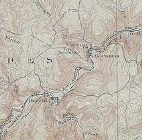
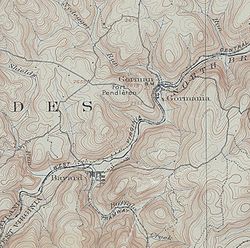
Geography
Bayard is located at 39°16′19"N 79°21′54"W (39.272062, -79.365043).According to the United States Census Bureau
United States Census Bureau
The United States Census Bureau is the government agency that is responsible for the United States Census. It also gathers other national demographic and economic data...
, the town has a total area of 0.3 square miles (0.8 km²), all land.
Demographics
As of the censusCensus
A census is the procedure of systematically acquiring and recording information about the members of a given population. It is a regularly occurring and official count of a particular population. The term is used mostly in connection with national population and housing censuses; other common...
of 2000, there were 299 people, 141 households, and 93 families residing in the town. The population density
Population density
Population density is a measurement of population per unit area or unit volume. It is frequently applied to living organisms, and particularly to humans...
was 949.2 inhabitants per square mile (372.4/km²). There were 172 housing units at an average density of 546.0 per square mile (214.2/km²). The racial makeup of the town was 96.66% White, 0.67% African American, 2.01% Native American, and 0.67% from two or more races. Hispanic or Latino of any race were 0.67% of the population.
There were 141 households out of which 21.3% had children under the age of 18 living with them, 50.4% were married couples
Marriage
Marriage is a social union or legal contract between people that creates kinship. It is an institution in which interpersonal relationships, usually intimate and sexual, are acknowledged in a variety of ways, depending on the culture or subculture in which it is found...
living together, 9.9% had a female householder with no husband present, and 34.0% were non-families. 29.8% of all households were made up of individuals and 18.4% had someone living alone who was 65 years of age or older. The average household size was 2.12 and the average family size was 2.60.
In the town the population was spread out with 16.4% under the age of 18, 9.4% from 18 to 24, 21.7% from 25 to 44, 32.1% from 45 to 64, and 20.4% who were 65 years of age or older. The median age was 46 years. For every 100 females there were 104.8 males. For every 100 females age 18 and over, there were 101.6 males.
The median income for a household in the town was $25,156, and the median income for a family was $31,750. Males had a median income of $30,313 versus $14,583 for females. The per capita income
Per capita income
Per capita income or income per person is a measure of mean income within an economic aggregate, such as a country or city. It is calculated by taking a measure of all sources of income in the aggregate and dividing it by the total population...
for the town was $13,882. About 7.2% of families and 14.3% of the population were below the poverty line, including 22.5% of those under the age of eighteen and 5.3% of those sixty five or over.
External links