

Battlefield, Shropshire
Encyclopedia

Shrewsbury
Shrewsbury is the county town of Shropshire, in the West Midlands region of England. Lying on the River Severn, it is a civil parish home to some 70,000 inhabitants, and is the primary settlement and headquarters of Shropshire Council...
town centre in Shropshire
Shropshire
Shropshire is a county in the West Midlands region of England. For Eurostat purposes, the county is a NUTS 3 region and is one of four counties or unitary districts that comprise the "Shropshire and Staffordshire" NUTS 2 region. It borders Wales to the west...
, England
England
England is a country that is part of the United Kingdom. It shares land borders with Scotland to the north and Wales to the west; the Irish Sea is to the north west, the Celtic Sea to the south west, with the North Sea to the east and the English Channel to the south separating it from continental...
.
The village is today split between three parishes
Civil parish
In England, a civil parish is a territorial designation and, where they are found, the lowest tier of local government below districts and counties...
- Shrewsbury, Astley
Astley, Shropshire
Astley is a small village and civil parish in Shropshire, England. The official 2001 census recorded 454 people living in the parish and 116 in the village itself.The village lies near to the A53 and A49 roads....
and Pimhill
Pimhill
Pimhill is a geographically large civil parish in Shropshire, England, to the north of Shrewsbury. It is named after a hill, which rises to 163m, sometimes spelt Pim Hill...
.
Battle of Shrewsbury
It was roughly here that the Battle of ShrewsburyBattle of Shrewsbury
The Battle of Shrewsbury was a battle fought on 21 July 1403, waged between an army led by the Lancastrian King, Henry IV, and a rebel army led by Henry "Hotspur" Percy from Northumberland....
of 1403 took place. A church, commonly known as "Battlefield Church", but officially St. Mary Magdalene Church
St Mary Magdalene's Church, Battlefield
St Mary Magdalene's Church, Battlefield, is a redundant Anglican church in the village of Battlefield, Shropshire, England. It has been designated by English Heritage as a Grade II* listed building, and is under the care of the Churches Conservation Trust.-History:The church is built on the...
, was built in memory of the thousands who died.
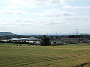
Modern day Battlefield
The A49A49 road
The A49 is a major road in western England, which traverses the Welsh Marches region. It runs north from Ross-on-Wye in Herefordshire via Hereford, Leominster, Ludlow, Shrewsbury and Whitchurch, then continues through central Cheshire to Warrington and Wigan before terminating at its junction with...
runs through Battlefield, on its way from Shrewsbury to Whitchurch
Whitchurch, Shropshire
Whitchurch is a market town in Shropshire, England on the border between England and Wales. It is the oldest continuously inhabited town in Shropshire. According to the 2001 Census, the population of the town is 8,673, with a more recent estimate putting the population of the town at 8,934...
, as does the Welsh Marches Line
Welsh Marches Line
The Welsh Marches Line , known historically as the North and West Route, is the railway line running from Newport in south-east Wales to Shrewsbury in the West Midlands region of England by way of Abergavenny, Hereford and Craven Arms, and thence to Crewe via Whitchurch...
(the Shrewsbury to Crewe
Crewe
Crewe is a railway town within the unitary authority area of Cheshire East and the ceremonial county of Cheshire, England. According to the 2001 census the urban area had a population of 67,683...
railway line). The A53
A53 road
The A53 is a primary route in northern England, that runs from Buxton in Derbyshire to Shrewsbury in Shropshire.-Route of Road:The A53 begins in the centre of Buxton off the A6 road, before meeting the A515 road at a roundabout. Out of the town, it has a junction with the A54 road before...
begins its route at Battlefield.
Battlefield has two pubs. The Red Lion is the elder pub, and The Two Henrys is to the north of the Battlefield roundabout, as is the church, which lies just off the A49.
Also recently opened adjacent to the Two Henrys is a new Spar Convenience store, which is the first in the UK to have a smoothie bar, and also Wi-fi networking.
Expansion of Shrewsbury
The town of Shrewsbury has over the past 10 years grown substantially in this area and the village is now part of the town. It is however split by a large Shrewsbury bypass roundabout ("Battlefield Roundabout"), one of the busiest in the county town.The new Shrewsbury livestock market and a small hotel and service station has just been built just off the A53 near the Battlefield Roundabout.
An industrial and business estate, the Battlefield Enterprise Park, has grown up in between the older Shrewsbury suburb of Harlescott
Harlescott
Harlescott is a suburb of the town of Shrewsbury, county town of Shropshire. It is one of the most industrial parts of the town, and is the 5th most deprived ward in non-metropolitan Shropshire Neighbouring suburbs include Sundorne to the east and Ditherington to the south...
and Battlefield. It is located on the site of the Battle of Shrewsbury and the village of Battlefield is nearby. A large site of where the battle took place is, however, protected as a heritage site. Even so, the Battlefield Link Road (the A5124
A5124 road
The A5124 is a road in Shropshire, England, that forms part of the northern section of the Shrewsbury by-pass. It is better known locally as the Battlefield Link Road....
) runs straight through it and a car park has been built for visitors. The first businesses moved in during the mid-1990s, though the park became more established later that decade when the Battlefield Link Road, the A5124
A5124 road
The A5124 is a road in Shropshire, England, that forms part of the northern section of the Shrewsbury by-pass. It is better known locally as the Battlefield Link Road....
, was built. The park is near the A49
A49 road
The A49 is a major road in western England, which traverses the Welsh Marches region. It runs north from Ross-on-Wye in Herefordshire via Hereford, Leominster, Ludlow, Shrewsbury and Whitchurch, then continues through central Cheshire to Warrington and Wigan before terminating at its junction with...
and A53
A53 road
The A53 is a primary route in northern England, that runs from Buxton in Derbyshire to Shrewsbury in Shropshire.-Route of Road:The A53 begins in the centre of Buxton off the A6 road, before meeting the A515 road at a roundabout. Out of the town, it has a junction with the A54 road before...
and it is also adjacent to the Welsh Marches Line
Welsh Marches Line
The Welsh Marches Line , known historically as the North and West Route, is the railway line running from Newport in south-east Wales to Shrewsbury in the West Midlands region of England by way of Abergavenny, Hereford and Craven Arms, and thence to Crewe via Whitchurch...
.
See also
- Upper BattlefieldUpper Battlefield, ShropshireUpper Battlefield is a small village in Shropshire, England.It lies on the A49 just north of Battlefield. The Welsh Marches railway line runs through the village, and it lies in the parish of Astley....
, - UffingtonUffington, ShropshireUffington is a village in the English county of Shropshire. It lies between Haughmond Hill and the River Severn, 3 miles east from the town centre of Shrewsbury, at .Uffington is home to a church and a pub, the Corbet Arms...
, a nearby village, - Haughmond HillHaughmond HillHaughmond Hill is a small, shallow hill in the English county of Shropshire. It is covered by woodland for the most part, although there is an open cast quarry in use. Its proximity to the town of Shrewsbury has meant that it has become something of a forest park, with guided paths, car parking...
, a nearby wood and landmark.