
Barkhamsted, Connecticut
Encyclopedia
Barkhamsted is a town
in Litchfield County
in Connecticut
and contains six villages, West Hill, Mallory, Center Hill, Washington Hill, Pleasant Valley and Riverton. The population was 3,494 at the 2000 census. Barkhamsted was named after Berkhamsted
, Hertfordshire
, England.http://www.sots.ct.gov/RegisterManual/SectionVII/townorder.htm
, the town has a total area of 38.8 square miles (100.5 km²), of which, 36.2 square miles (93.8 km²) of it is land and 2.6 square miles (6.7 km²) of it (6.72%) is water. A high percentage of the land in the town is owned by the State of Connecticut as state forest (People's State Forest, American Legion State Forest, Tunxis State Forest, and Enders State Forest) and by the Metropolitan District Commission (MDC) as water supply area. Major bodies of water include the Barkhamsted Reservoir, Lake McDonough, and the Farmington River.
As of the census
of 2000, there were 3,494 people, 1,334 households, and 1,036 families residing in the town. The population density
was 96.5 people per square mile (37.2/km²). There were 1,436 housing units at an average density of 39.6 per square mile (15.3/km²). The racial makeup of the town was 98.54% White, 0.06% African American, 0.17% Native American, 0.40% Asian, 0.29% from other races
, and 0.54% from two or more races. Hispanic or Latino of any race were 0.89% of the population.
There were 1,334 households out of which 36.2% had children under the age of 18 living with them, 68.2% were married couples
living together, 6.2% had a female householder with no husband present, and 22.3% were non-families. 16.9% of all households were made up of individuals and 4.9% had someone living alone who was 65 years of age or older. The average household size was 2.62 and the average family size was 2.95.
In the town the population was spread out with 25.0% under the age of 18, 4.8% from 18 to 24, 31.3% from 25 to 44, 28.8% from 45 to 64, and 10.1% who were 65 years of age or older. The median age was 40 years. For every 100 females there were 101.3 males. For every 100 females age 18 and over, there were 100.8 males.
The median income for a household in the town was $65,972, and the median income for a family was $73,218. Males had a median income of $51,925 versus $38,102 for females. The per capita income
for the town was $28,961. About 1.8% of families and 3.0% of the population were below the poverty line, including 3.8% of those under age 18 and 1.4% of those age 65 or over.
There are three fire departments located in Barkhamsted. The Pleasant Valley Volunteer Fire Department, Riverton Volunteer Fire Company, and Barkhamsted East Volunteer Fire Company. The town employs one paid daytime driver/firefighter to assist the volunteers during normal work hours.
Emergency medical care is provided by the Winsted Area Ambulance Association, the New Hartford Volunteer Ambulance Association, and a Campion Paramedic. Both Winsted and New Hartford are volunteer based services.
and the village of Pleasant Valley is off Route 44 (via Route 318). Bradley International Airport is approximately 30 miles east.
 Home of the historical Saville Dam
, and People's State Forest, where Stone Museum is located, http://www.stonemuseum.org/.
Within the Barkhamsted Reservoir lies the foundations of Barkhamsted Hollow
, the historic center of town that was purchased by The Metropolitan District Commission in the early 20th century to create a reservoir to serve the Hartford area. This area was flooded following the construction of the Saville Dam on the East Branch of the Farmington River, and took 8 years to fill.
Just south of the Barkhamsted Reservoir is Lake McDonough, also known as the compensating reservoir and owned by the MDC. Originally created to ensure the riparian rights of downstream mill owners, this lake now serves the recreational interests of the surrounding area with several beaches, boating, and fishing.
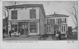
The center Pleasant Valley contains the Pleasant Valley General Store, the Barkhamsted Elementary School, the Pleasant Valley Drive-In, the post office (zip code 06063), and the town hall.
The center of Riverton holds a post office (zip code 06065), the Riverton General store, the Riverton Inn, the Riverton Congregational Church, the grange, and the Riverton fair grounds. This is also the location of the annual Riverton Fair, which takes place the second weekend of October each year. The Riverton Fair is the last fair of the year in Connecticut.
The West Branch of the Farmington River is designated as a Wild and Scenic river. It runs through the villages of Riverton and Pleasant Valley and hosts fishermen year-round in the catch-and-release section. On the opening day of fishing season each year, a fishing tournament is held in Riverton, that draws anglers from throughout CT, NY,and MA.
New England town
The New England town is the basic unit of local government in each of the six New England states. Without a direct counterpart in most other U.S. states, New England towns are conceptually similar to civil townships in other states, but are incorporated, possessing powers like cities in other...
in Litchfield County
Litchfield County, Connecticut
Litchfield County is a county located in the northwestern corner of the U.S. state of Connecticut. Litchfield County has the lowest population density of any county in Connecticut but is geographically the state's largest county. As of 2010 the population was 189,927...
in Connecticut
Connecticut
Connecticut is a state in the New England region of the northeastern United States. It is bordered by Rhode Island to the east, Massachusetts to the north, and the state of New York to the west and the south .Connecticut is named for the Connecticut River, the major U.S. river that approximately...
and contains six villages, West Hill, Mallory, Center Hill, Washington Hill, Pleasant Valley and Riverton. The population was 3,494 at the 2000 census. Barkhamsted was named after Berkhamsted
Berkhamsted
-Climate:Berkhamsted experiences an oceanic climate similar to almost all of the United Kingdom.-Castle:...
, Hertfordshire
Hertfordshire
Hertfordshire is a ceremonial and non-metropolitan county in the East region of England. The county town is Hertford.The county is one of the Home Counties and lies inland, bordered by Greater London , Buckinghamshire , Bedfordshire , Cambridgeshire and...
, England.http://www.sots.ct.gov/RegisterManual/SectionVII/townorder.htm
Geography
According to the United States Census BureauUnited States Census Bureau
The United States Census Bureau is the government agency that is responsible for the United States Census. It also gathers other national demographic and economic data...
, the town has a total area of 38.8 square miles (100.5 km²), of which, 36.2 square miles (93.8 km²) of it is land and 2.6 square miles (6.7 km²) of it (6.72%) is water. A high percentage of the land in the town is owned by the State of Connecticut as state forest (People's State Forest, American Legion State Forest, Tunxis State Forest, and Enders State Forest) and by the Metropolitan District Commission (MDC) as water supply area. Major bodies of water include the Barkhamsted Reservoir, Lake McDonough, and the Farmington River.
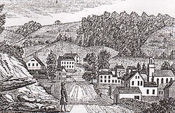
Principal communities
- Barkhamsted HollowBarkhamsted HollowBarkhamsted Hollow was a village in northwestern Connecticut. It was part of the town of Barkhamsted, Connecticut in Litchfield County, Connecticut, incorporated as part of Barkhamsted in 1779...
(historical; became the Barkhamsted Reservoir in the early 20th c.) - Center Hill
- Pleasant Valley
- Riverton
Demographics
As of 2010 Barhamsted had a population of 3,799. The racial composition of the population was 97.5% white, 0.3% black or African American, 0.6% Asian, 0.6% from some other race and 1.1% reporting two or more races. 1.5% of the population was Hispanic or Latino of any race.As of the census
Census
A census is the procedure of systematically acquiring and recording information about the members of a given population. It is a regularly occurring and official count of a particular population. The term is used mostly in connection with national population and housing censuses; other common...
of 2000, there were 3,494 people, 1,334 households, and 1,036 families residing in the town. The population density
Population density
Population density is a measurement of population per unit area or unit volume. It is frequently applied to living organisms, and particularly to humans...
was 96.5 people per square mile (37.2/km²). There were 1,436 housing units at an average density of 39.6 per square mile (15.3/km²). The racial makeup of the town was 98.54% White, 0.06% African American, 0.17% Native American, 0.40% Asian, 0.29% from other races
Race (United States Census)
Race and ethnicity in the United States Census, as defined by the Federal Office of Management and Budget and the United States Census Bureau, are self-identification data items in which residents choose the race or races with which they most closely identify, and indicate whether or not they are...
, and 0.54% from two or more races. Hispanic or Latino of any race were 0.89% of the population.
There were 1,334 households out of which 36.2% had children under the age of 18 living with them, 68.2% were married couples
Marriage
Marriage is a social union or legal contract between people that creates kinship. It is an institution in which interpersonal relationships, usually intimate and sexual, are acknowledged in a variety of ways, depending on the culture or subculture in which it is found...
living together, 6.2% had a female householder with no husband present, and 22.3% were non-families. 16.9% of all households were made up of individuals and 4.9% had someone living alone who was 65 years of age or older. The average household size was 2.62 and the average family size was 2.95.
In the town the population was spread out with 25.0% under the age of 18, 4.8% from 18 to 24, 31.3% from 25 to 44, 28.8% from 45 to 64, and 10.1% who were 65 years of age or older. The median age was 40 years. For every 100 females there were 101.3 males. For every 100 females age 18 and over, there were 100.8 males.
The median income for a household in the town was $65,972, and the median income for a family was $73,218. Males had a median income of $51,925 versus $38,102 for females. The per capita income
Per capita income
Per capita income or income per person is a measure of mean income within an economic aggregate, such as a country or city. It is calculated by taking a measure of all sources of income in the aggregate and dividing it by the total population...
for the town was $28,961. About 1.8% of families and 3.0% of the population were below the poverty line, including 3.8% of those under age 18 and 1.4% of those age 65 or over.
| Voter Registration and Party Enrollment as of October 25, 2005 | |||||||||||||||||||||||||
|---|---|---|---|---|---|---|---|---|---|---|---|---|---|---|---|---|---|---|---|---|---|---|---|---|---|
| Party | Active Voters | Inactive Voters | Total Voters | Percentage |
Republican Republican Party (United States) The Republican Party is one of the two major contemporary political parties in the United States, along with the Democratic Party. Founded by anti-slavery expansion activists in 1854, it is often called the GOP . The party's platform generally reflects American conservatism in the U.S... |
707 | 21 | 728 | 28.26% |
Democratic Democratic Party (United States) The Democratic Party is one of two major contemporary political parties in the United States, along with the Republican Party. The party's socially liberal and progressive platform is largely considered center-left in the U.S. political spectrum. The party has the lengthiest record of continuous... |
598 | 13 | 611 | 23.72% |
Unaffiliated | 1,175 | 46 | 1,221 | 47.40% |
Minor Parties | 15 | 1 | 16 | 0.62% | |
| Total | 2,495 | 81 | 2,576 | 100% | |||||||||||||||||||||
Services
The town of Barkhamsted has one elementary school located in the village of Pleasant Valley. Its high school and middle school students attend Northwestern Regional 7 with students from three neighboring towns.There are three fire departments located in Barkhamsted. The Pleasant Valley Volunteer Fire Department, Riverton Volunteer Fire Company, and Barkhamsted East Volunteer Fire Company. The town employs one paid daytime driver/firefighter to assist the volunteers during normal work hours.
Emergency medical care is provided by the Winsted Area Ambulance Association, the New Hartford Volunteer Ambulance Association, and a Campion Paramedic. Both Winsted and New Hartford are volunteer based services.
Transportation
There is no public transportation in Barkhamsted. Principle means of transportation is the automobile. The primary state highways in town are Route 44, Route 20, Route 219, Route 318, and Route 181. The village of Riverton is located along Route 20Route 20 (Connecticut)
Route 20 is a state highway in the U.S. state of Connecticut. It extends from Route 8 in rural Winchester to I-91 in Windsor. Route 20 consists of two distinct sections: a long, winding, scenic rural road, and a section of the freeway linking I-91 to Bradley International...
and the village of Pleasant Valley is off Route 44 (via Route 318). Bradley International Airport is approximately 30 miles east.
Notable locations
Saville Dam
Saville Dam is an earthen embankment dam with masonry work on the eastern branch of the Farmington River 4 km southwest of Barkhamsted, Connecticut. The dam is 135 ft. tall and 1,950 ft. long and has an uncontrolled spillway on its western portion...
, and People's State Forest, where Stone Museum is located, http://www.stonemuseum.org/.
Within the Barkhamsted Reservoir lies the foundations of Barkhamsted Hollow
Barkhamsted Hollow
Barkhamsted Hollow was a village in northwestern Connecticut. It was part of the town of Barkhamsted, Connecticut in Litchfield County, Connecticut, incorporated as part of Barkhamsted in 1779...
, the historic center of town that was purchased by The Metropolitan District Commission in the early 20th century to create a reservoir to serve the Hartford area. This area was flooded following the construction of the Saville Dam on the East Branch of the Farmington River, and took 8 years to fill.
Just south of the Barkhamsted Reservoir is Lake McDonough, also known as the compensating reservoir and owned by the MDC. Originally created to ensure the riparian rights of downstream mill owners, this lake now serves the recreational interests of the surrounding area with several beaches, boating, and fishing.
The center Pleasant Valley contains the Pleasant Valley General Store, the Barkhamsted Elementary School, the Pleasant Valley Drive-In, the post office (zip code 06063), and the town hall.
The center of Riverton holds a post office (zip code 06065), the Riverton General store, the Riverton Inn, the Riverton Congregational Church, the grange, and the Riverton fair grounds. This is also the location of the annual Riverton Fair, which takes place the second weekend of October each year. The Riverton Fair is the last fair of the year in Connecticut.
The West Branch of the Farmington River is designated as a Wild and Scenic river. It runs through the villages of Riverton and Pleasant Valley and hosts fishermen year-round in the catch-and-release section. On the opening day of fishing season each year, a fishing tournament is held in Riverton, that draws anglers from throughout CT, NY,and MA.
On the National Register of Historic Places
- American Legion Forest CCC ShelterAmerican Legion Forest CCC ShelterAmerican Legion Forest CCC Shelter, located on the west side of West River Road within the American Legion State Forest, Barkhamsted, Connecticut, was built in 1935 by the Civilian Conservation Corps...
— west side of West River Road, American Legion State Forest (added in 1986) - Barkhamsted Center Historic District — 119, 131 Center Hill Road; 2,5,6,8 Old Town Hall Road (added in 1999)
- Beaver Meadow Complex Prehistoric Archeological District (added in 1988)
- Lighthouse Archeological Site (5-37) (added in 1991)
- William Moore, Jr., House — 5 Mountain Road (added May 14, 1999)
- Old Riverton Inn — 436 E. River Rd. (added in 1992)
- Peoples Forest Museum — Greenwood Road, Peoples State Forest (added in 1986)
- Riverton Historic District (Barkhamsted, Connecticut)Riverton Historic District (Barkhamsted, Connecticut)Riverton Historic District is a historic district in the town of Barkhamsted, Connecticut that was listed on the National Register of Historic Places in 2007.It includes examples of Colonial and Early Republic architecture....
— (added in 2007) - Union Church/St. Paul's ChurchUnion Church/St. Paul's ChurchUnion Church/St. Paul's Church is a historic church on Riverton Road in the Riverton section of Barkhamsted, Connecticut.It was built in 1829 and added to the National Register of Historic Places in 1985....
— Riverton Road (added in 1985)