
Bagmati Zone
Encyclopedia
Bagmati Zone
Bagmati Zone ' onMouseout='HidePop("31624")' href="/topics/Nepal">Nepal
which is named after the Bagmati River. It is in Central Development Region of Nepal. The zone contains the Kathmandu Valley
with its conurbation of 1.5 million inhabitants.
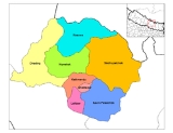
Bagmati is divided into eight districts:
Bagmati Zone ' onMouseout='HidePop("31624")' href="/topics/Nepal">Nepal
Nepal
Nepal , officially the Federal Democratic Republic of Nepal, is a landlocked sovereign state located in South Asia. It is located in the Himalayas and bordered to the north by the People's Republic of China, and to the south, east, and west by the Republic of India...
which is named after the Bagmati River. It is in Central Development Region of Nepal. The zone contains the Kathmandu Valley
Kathmandu Valley
The Kathmandu Valley , located in Nepal, lies at the crossroads of ancient civilizations of Asia, and has at least 130 important monuments, including several places of pilgrimage for the Hindus and the Buddhists. There are seven UNESCO World Heritage Sites within this valley.-Etymology:The city of...
with its conurbation of 1.5 million inhabitants.
Bagmati is divided into eight districts:
| District | Headquarters |
|---|---|
| Bhaktapur District Bhaktapur District Bhaktapur district, located in the eastern part of Kathmandu valley, is the smallest among the seventy-five districts of Nepal. The district, with Bhaktapur as its district headquarters, covers an area of 119 km² and has a population of 225,461.... |
Bhaktapur Bhaktapur Bhaktapur , also Bhadgaon or Khwopa is an ancient Newar town in the east corner of the Kathmandu Valley, Nepal. It is located in Bhaktapur District in the Bagmati Zone... |
| Dhading District Dhading District -Geography:The district spreads from 27'40" E to 28'17" E and 80'17"N to 84'35"N. The mountain range "Ganesh" is the predominate mountain range located within Dhading. Some of the peaks are over 7,000 meters. The 8,000+ meter mountain "Manaslu" is clearly visible from much of Dhading, although it... |
Dhading |
| Lalitpur District Lalitpur District, Nepal Lalitpur District of 337,785. It is one of the three districts in the Kathmandu Valley, along with Kathmandu and Bhaktapur.Lalitpur District has many schools, colleges and hotels. Adarsha Vidya Mandir, St. Xavier's School, St... |
Patan |
| Kathmandu District Kathmandu District Kathmandu District is a district located in Kathmandu Valley, Bagmati Zone of Nepal, a landlocked country in South Asia. It is one of the seventy-five districts of Nepal, covers an area of 395 km2 and is the most densely populated district of Nepal with a population of 1,081,845 in 2001... |
Kathmandu |
| Kavrepalanchok District Kavrepalanchok District -Towns and villages:Anaikot Balathali Balting Baluwa Baluwapatti Deupur Banakhu Chor Banepa Batase Bekhsimle Bhimkhori Bhumidanda Bhumlutar Birtadeurali Bolde Fediche Budhakhani Chalal Ganeshsthan Chandeni Mandan Choubas Chyamrangbesi... |
Dhulikhel Dhulikhel Dhulikhel is the administrative centre of Kavrepalanchok District, Nepal. At the time of the 1991 Nepal census it had a population of 9812 people in 1624 households. Dhulikhel lies along the B.P. Highway and Arniko Highway. Arniko Highway connects Kathmandu, Nepal's capital city with Tibet's... |
| Nuwakot District Nuwakot District Nuwakot District of 288,478.The district contains places of historical significance such as Nuwakot Palace located in the village of Nuwakot and Devighat located at the confluence of the Tadi and Trishuli Rivers.-Towns and villages:... |
Bidur Bidur Bidur is the capital of Nuwakot District in Bagmati Zone, Nepal. At the time of the 1991 Nepal census it had a population of 18694 and had 3736 houses in it.In February 2008 terrorists damaged the town's water supply plant.... |
| Rasuwa District Rasuwa District Rasuwa District of 44,731.Gosaikunda lake is located in the district.-Village Development Committees :*Bhorle*Briddhim*Chilime*Dandagaun*Dhaibung*Dhunche*Gatlang*Goljung*Haku*Jibjibe*Khamjim*Laharepauwa*Langtang*Ramche*Saramthali... |
Dhunche Dhunche Dhunche is the capital of Rasuwa District in Bagmati Zone, Nepal. It is located at at an altitude of . At the time of the 2001 Nepal census it had a population of 2,535 people residing in 604 individual households.... |
| Sindhupalchok District | Chautara Chautara Chautara is a village in Sindhupalchok District in the Bagmati Zone of central Nepal. At the time of the 1991 Nepal census it had a population of 3734 and had 782 houses in the village.... |
See also
- Zones of NepalZones of NepalNepal is divided into 14 administrative zones , and 75 districts . The 14 administrative zones are grouped into five development regions...
- Regions of NepalRegions of NepalNepal is divided into 14 administrative zones , which are divided into 75 districts . The 14 administrative zones are grouped into five development regions...
- Districts of NepalDistricts of NepalNepal's 14 administrative zones are subdivided into 75 districts . These districts are listed below, by zone...