
Baardskeerdersbos
Encyclopedia
Overberg
Overberg is a district in South Africa to the east of Cape Town beyond the Hottentots-Holland mountains. It lies along the Cape Province's south coast between the Cape Peninsula and the region known as the Garden Route in the east...
region of the Western Cape
Western Cape
The Western Cape is a province in the south west of South Africa. The capital is Cape Town. Prior to 1994, the region that now forms the Western Cape was part of the much larger Cape Province...
province of South Africa
South Africa
The Republic of South Africa is a country in southern Africa. Located at the southern tip of Africa, it is divided into nine provinces, with of coastline on the Atlantic and Indian oceans...
.
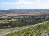
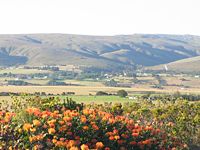
Geography
Baardskeerdersbos is located about 20km east of Gansbaai and 18km west of ElimElim, Western Cape
Elim is a village on the Agulhas Plain in the Western Cape of South Africa. It was established in 1824 by German missionaries as a Moravian mission station. When selecting the location, the missionaries placed a high priority on the proximity of water and on terrain that was suitable for planting...
, on the gravel road linking Gansbaai to Bredasdorp
Bredasdorp
Bredasdorp is a town in the Southern Overberg region of the Western Cape, South Africa, and the main economic and service hub of that region. It lies on the northern edge of the Agulhas Plain, about south-east of Cape Town and north of Cape Agulhas, the southernmost tip of Africa.-History:The...
. It lies on the southern slopes of a mountain called Perdekop ("Horse Hill"), at the base of the Boskloof ("Forest Gorge") through which a small river flows south off the mountain. Just south of the village the Boesmansrivier ("Bushman
Bushmen
The indigenous people of Southern Africa, whose territory spans most areas of South Africa, Zimbabwe, Lesotho, Mozambique, Swaziland, Botswana, Namibia, and Angola, are variously referred to as Bushmen, San, Sho, Barwa, Kung, or Khwe...
's River") flows from east to west; the Boskloof stream flows into this river.
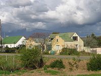
History
The first reference to this area by Europeans dates to 1660, when Jan van Riebeek sent an expedition to explore the Overberg. The farm "Baarscheerders Bosch" number 213 in the BredasdorpBredasdorp
Bredasdorp is a town in the Southern Overberg region of the Western Cape, South Africa, and the main economic and service hub of that region. It lies on the northern edge of the Agulhas Plain, about south-east of Cape Town and north of Cape Agulhas, the southernmost tip of Africa.-History:The...
registration district, which included the village and the surrounding farmland and hillside, was surveyed for a Phillip Fourie Senior in 1831; that original farm has since been subdivided considerably into separate farms, smallholding
Smallholding
A smallholding is a farm of small size.In third world countries, smallholdings are usually farms supporting a single family with a mixture of cash crops and subsistence farming. As a country becomes more affluent and farming practices become more efficient, smallholdings may persist as a legacy of...
s and plots. The current church in Baardskeerdersbos was built in 1921 and is a National Monument. For a long time the village remained rural and undisturbed, but recently it has been discovered as a quiet getaway particularly for residents of Cape Town
Cape Town
Cape Town is the second-most populous city in South Africa, and the provincial capital and primate city of the Western Cape. As the seat of the National Parliament, it is also the legislative capital of the country. It forms part of the City of Cape Town metropolitan municipality...
; several new houses have been built, and several more renovated.
Name
The name "Baardskeerdersbos" in Afrikaans or "Baardscheerders Bosch" in the original DutchDutch language
Dutch is a West Germanic language and the native language of the majority of the population of the Netherlands, Belgium, and Suriname, the three member states of the Dutch Language Union. Most speakers live in the European Union, where it is a first language for about 23 million and a second...
literally means "Beard Shaver's Forest". The accepted explanation for this name is that a species of solifuge inhabits the area, and that this arachnid is referred to as a "beard shaver" because it cuts hair to use for nest-building. The well-known cartographer and writer Peter Slingsby wrote a book entitled "Beard Shaver’s Bush: Place Names in the Cape" (ISBN 0-620-24965-X) which discusses the origin of this and many other place names.