

Atsumi Peninsula
Encyclopedia
Aichi Prefecture
is a prefecture of Japan located in the Chūbu region. The region of Aichi is also known as the Tōkai region. The capital is Nagoya. It is the focus of the Chūkyō Metropolitan Area.- History :...
, central Honshū
Honshu
is the largest island of Japan. The nation's main island, it is south of Hokkaido across the Tsugaru Strait, north of Shikoku across the Inland Sea, and northeast of Kyushu across the Kanmon Strait...
, Japan
Japan
Japan is an island nation in East Asia. Located in the Pacific Ocean, it lies to the east of the Sea of Japan, China, North Korea, South Korea and Russia, stretching from the Sea of Okhotsk in the north to the East China Sea and Taiwan in the south...
.
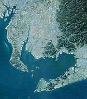
Atsumi Peninsula is a narrow strip of land running approximately 50 kilometres (31.1 mi) east-west, separating Mikawa Bay
Mikawa Bay
thumb|right|Mikawa Bay Mikawa Bay is a bay to the south of Aichi Prefecture, Japan, surrounded by Chita Peninsula to the west and Atsumi Peninsula to the east and south. Its area is approximately 604 km2...
(to the north) from the Philippine Sea
Philippine Sea
The Philippine Sea is a marginal sea east and north of the Philippines occupying an estimated surface area of 2 million mi² on the western part of the North Pacific Ocean...
to the south. It faces the Chita Peninsula
Chita Peninsula
Chita Peninsula is a peninsula to the south of Aichi Prefecture, central Honshū, Japan. It runs approximately north-south. To the west is Ise Bay, while to the east it encloses Mikawa Bay. It faces the Atsumi Peninsula southeast across Mikawa Bay.-External links:...
southeast across Mikawa Bay. It has a width ranging from 5 kilometres (3.1 mi) to 8 kilometres (5 mi), and its highest point is 328 metres (1,076.1 ft). Its total area is approximately 200 square kilometers.
Atsumi Peninsula is noted for its temperature climate, due to the warm Kuroshio Current
Kuroshio Current
The Kuroshio is a north-flowing ocean current on the west side of the North Pacific Ocean. It is similar to the Gulf Stream in the North Atlantic and is part of the North Pacific ocean gyre...
offshore. The rock formations at its tip, the Iragomisaki, and its beaches are part of the Mikawa Wan Quasi-National Park
Mikawa Wan Quasi-National Park
is a Quasi-National Park in Aichi Prefecture, Japan. It is rated a protected landscape according to the IUCN.The park includes the coastal areas of Atsumi Peninsula, the Pacific shoreline of Chita Peninsula as well as islands and portion of the northern shoreline of Mikawa Bay.It was founded on 10...
. Politically, almost all of the peninsula falls within the borders of the city of Tahara
Tahara, Aichi
is a city located in Aichi Prefecture, Japan. As of August 2011, the city had an estimated population of 63,886 and a population density of 338 persons per km². The total area was 188.81 km².-Geography:...
, with its "neck" within the city of Toyohashi
Toyohashi, Aichi
is a city located in Aichi Prefecture, Japan.The city was founded on August 1, 1906. As of January 1, 2010, the city has an estimated population of 383,691 and a density of 1,468.62 persons per km². The total area is . By size, Toyohashi was Aichi Prefecture's second-largest city until March 31,...
.
Reference
Japan:An Illustrated Encyclopedia. Kodansha (1993) ISBN 406205938X34°34′46"N 138°00′58"E (Iragomisaki:westernmost point)