
Ashmore
Encyclopedia
Ashmore is a small village
in the North Dorset
district of Dorset
, England
; situated 20 miles (32.2 km) south-west of Salisbury
. The local travel links are located 7 miles (11.3 km) from the village to Tisbury railway station
and 18 miles (29 km) to Bournemouth International Airport. The main road running through the village is North Road. The village has a population of 162 according to the 2001 Census
.
It is situated on Cranborne Chase
five miles (8 km) south east of Shaftesbury
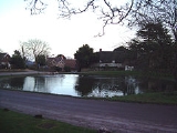
. The village consists of a church and 83 old stone cottages and farms, many with thatched roofs. The village is situated on Chalk
rock which is permeable and therefore dry, and the village is built around a clay
lined dew pond
which provided water before pipes were installed. At over 700 feet (213.4 m) above sea level the village is the highest in Dorset.
The village is situated on the Roman road
from Bath to Badbury Rings
, and the pond may have been significant in Roman
times. It is probable that there was a settlement at Ashmore in Roman times, though the village name is Saxon
and there is little Roman archaeology
in the village.
Village
A village is a clustered human settlement or community, larger than a hamlet with the population ranging from a few hundred to a few thousand , Though often located in rural areas, the term urban village is also applied to certain urban neighbourhoods, such as the West Village in Manhattan, New...
in the North Dorset
North Dorset
North Dorset is a local government district in Dorset, England. It is largely rural, but includes the towns of Blandford Forum, Gillingham, Shaftesbury, Stalbridge and Sturminster Newton. Much of North Dorset is in the River Stour valley and is called the Blackmore Vale...
district of Dorset
Dorset
Dorset , is a county in South West England on the English Channel coast. The county town is Dorchester which is situated in the south. The Hampshire towns of Bournemouth and Christchurch joined the county with the reorganisation of local government in 1974...
, England
England
England is a country that is part of the United Kingdom. It shares land borders with Scotland to the north and Wales to the west; the Irish Sea is to the north west, the Celtic Sea to the south west, with the North Sea to the east and the English Channel to the south separating it from continental...
; situated 20 miles (32.2 km) south-west of Salisbury
Salisbury
Salisbury is a cathedral city in Wiltshire, England and the only city in the county. It is the second largest settlement in the county...
. The local travel links are located 7 miles (11.3 km) from the village to Tisbury railway station
Tisbury railway station
Tisbury railway station serves the village of Tisbury in Wiltshire, England. Opened in 1859, it is currently managed by South West Trains and is on its London Waterloo to Exeter line, from London.-History:...
and 18 miles (29 km) to Bournemouth International Airport. The main road running through the village is North Road. The village has a population of 162 according to the 2001 Census
United Kingdom Census 2001
A nationwide census, known as Census 2001, was conducted in the United Kingdom on Sunday, 29 April 2001. This was the 20th UK Census and recorded a resident population of 58,789,194....
.
It is situated on Cranborne Chase
Cranborne Chase
Cranborne Chase is a Chalk plateau in central southern England, straddling the counties Dorset, Hampshire and Wiltshire. The plateau is part of the English Chalk Formation and is adjacent to Salisbury Plain and the West Wiltshire Downs in the north, the Dorset Downs to the south west and the...
five miles (8 km) south east of Shaftesbury
Shaftesbury
Shaftesbury is a town in Dorset, England, situated on the A30 road near the Wiltshire border 20 miles west of Salisbury. The town is built 718 feet above sea level on the side of a chalk and greensand hill, which is part of Cranborne Chase, the only significant hilltop settlement in Dorset...
. The village consists of a church and 83 old stone cottages and farms, many with thatched roofs. The village is situated on Chalk
Chalk
Chalk is a soft, white, porous sedimentary rock, a form of limestone composed of the mineral calcite. Calcite is calcium carbonate or CaCO3. It forms under reasonably deep marine conditions from the gradual accumulation of minute calcite plates shed from micro-organisms called coccolithophores....
rock which is permeable and therefore dry, and the village is built around a clay
Clay
Clay is a general term including many combinations of one or more clay minerals with traces of metal oxides and organic matter. Geologic clay deposits are mostly composed of phyllosilicate minerals containing variable amounts of water trapped in the mineral structure.- Formation :Clay minerals...
lined dew pond
Dew pond
A dew pond is an artificial pond usually sited on the top of a hill, intended for watering livestock. Dew ponds are used in areas where a natural supply of surface water may not be readily available. The name dew pond is first found in the Journal of the Royal Agricultural Society in 1865...
which provided water before pipes were installed. At over 700 feet (213.4 m) above sea level the village is the highest in Dorset.
The village is situated on the Roman road
Roman road
The Roman roads were a vital part of the development of the Roman state, from about 500 BC through the expansion during the Roman Republic and the Roman Empire. Roman roads enabled the Romans to move armies and trade goods and to communicate. The Roman road system spanned more than 400,000 km...
from Bath to Badbury Rings
Badbury Rings
Badbury Rings is an Iron Age hill fort in east Dorset, England, dating from 800 BC and in use until the Roman occupation of 43 AD.-Iron Age:...
, and the pond may have been significant in Roman
Roman Britain
Roman Britain was the part of the island of Great Britain controlled by the Roman Empire from AD 43 until ca. AD 410.The Romans referred to the imperial province as Britannia, which eventually comprised all of the island of Great Britain south of the fluid frontier with Caledonia...
times. It is probable that there was a settlement at Ashmore in Roman times, though the village name is Saxon
Old English language
Old English or Anglo-Saxon is an early form of the English language that was spoken and written by the Anglo-Saxons and their descendants in parts of what are now England and southeastern Scotland between at least the mid-5th century and the mid-12th century...
and there is little Roman archaeology
Archaeology
Archaeology, or archeology , is the study of human society, primarily through the recovery and analysis of the material culture and environmental data that they have left behind, which includes artifacts, architecture, biofacts and cultural landscapes...
in the village.