
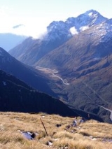
Arthur's Pass
Encyclopedia
Arthur's Pass is a mountain pass
in the Southern Alps
of the South Island
of New Zealand
. It marks part of the boundary between the West Coast and Canterbury regions, 140 km from Christchurch
and 95 km from Greymouth
. The pass lies in a saddle between the valleys of the Otira River
, a tributary of the Taramakau
, in the west and the Bealey River
in the east. Arthur's Pass lies on the border of the Selwyn
and Westland
districts.
A hamlet of the same name (Arthur's Pass
) is located about 5 km south of the mountain pass.
(1841–1934), who led the first party of Europeans across the pass in 1864. He had been informed of the presence of a pass, which had been used occasionally by Māori hunting parties by a West Coast Māori Chief, Tarapuhi. It is also believed that writer and explorer Samuel Butler
had seen the pass several years earlier, but was unable to explore it at that time. The timing was perfect, as the West Coast was soon to be hit by a gold rush
, and easy access to the Tasman
's coast became imperative.
passes over Arthur's Pass and is the highest of only three roads crossing the Southern Alps, the other crossings being the Haast Pass
and the Lewis Pass
. However, Porters Pass, on the same road, is higher (at 939 m) than Arthur's Pass, but it is not considered one of the alpine passes, as it is located in the Canterbury foothills not far away from Springfield
.
Previously prone to be blocked by landslides or avalanches, the road on the western side of the pass has seen extensive civil engineering
work in the late 1990s. Most notably, the impressive Otira Viaduct, near the settlement of Otira
and spanning 440 metres of unstable terrain, was completed in 1999.
, connecting Christchurch and the West Coast, crosses the Main Divide by means of the Otira Tunnel
, between Arthur's Pass township and Otira
. When opened in 1923, the tunnel was the longest in the British Empire.
Mountain pass
A mountain pass is a route through a mountain range or over a ridge. If following the lowest possible route, a pass is locally the highest point on that route...
in the Southern Alps
Southern Alps
The Southern Alps is a mountain range extending along much of the length of New Zealand's South Island, reaching its greatest elevations near the island's western side...
of the South Island
South Island
The South Island is the larger of the two major islands of New Zealand, the other being the more populous North Island. It is bordered to the north by Cook Strait, to the west by the Tasman Sea, to the south and east by the Pacific Ocean...
of New Zealand
New Zealand
New Zealand is an island country in the south-western Pacific Ocean comprising two main landmasses and numerous smaller islands. The country is situated some east of Australia across the Tasman Sea, and roughly south of the Pacific island nations of New Caledonia, Fiji, and Tonga...
. It marks part of the boundary between the West Coast and Canterbury regions, 140 km from Christchurch
Christchurch
Christchurch is the largest city in the South Island of New Zealand, and the country's second-largest urban area after Auckland. It lies one third of the way down the South Island's east coast, just north of Banks Peninsula which itself, since 2006, lies within the formal limits of...
and 95 km from Greymouth
Greymouth
Greymouth is the largest town in the West Coast region in the South Island of New Zealand, and the seat of the Grey District Council. The population of the whole Grey District is , which accounts for % of the West Coast's inhabitants...
. The pass lies in a saddle between the valleys of the Otira River
Otira River
The Otira River is located in the central South Island of New Zealand. It rises on the slopes of Mount Rolleston in the Southern Alps, and flows north for 20 km, passing through the town of Otira before joining the Taramakau River...
, a tributary of the Taramakau
Taramakau River
The Taramakau River is in the northwest of the South Island of New Zealand. It rises in the Southern Alps, 80 kilometres due east of Hokitika, and immediately below the saddle of the Harper's Pass, and runs westward for 75 kilometres into the Tasman Sea 15 kilometres south of Greymouth.Several...
, in the west and the Bealey River
Bealey River
The Bealey River is a small river located in the Southern Alps of New Zealand. It is a tributary of the Waimakariri River. Its valley forms the eastern approach to Arthur's Pass...
in the east. Arthur's Pass lies on the border of the Selwyn
Selwyn District
The Selwyn District is a predominantly rural area in central Canterbury, on the east coast of New Zealand's South Island. It is named after the Selwyn River, which is in turn named after Bishop George Selwyn, the first Anglican bishop of New Zealand who, in 1843 and 1844, travelled the length of...
and Westland
Westland District
Westland District is a territorial authority on the west coast of New Zealand's South Island. Its population is - Government :The Westland District is governed by an elected Council, headed by an elected Mayor. The Mayor is elected at large. The current Mayor is Maureen Pugh. Councillors are...
districts.
A hamlet of the same name (Arthur's Pass
Arthur's Pass
Arthur's Pass is a mountain pass in the Southern Alps of the South Island of New Zealand. It marks part of the boundary between the West Coast and Canterbury regions, 140 km from Christchurch and 95 km from Greymouth. The pass lies in a saddle between the valleys of the Otira River, a...
) is located about 5 km south of the mountain pass.
History
The pass is named after Sir Arthur Dudley DobsonArthur Dudley Dobson
Sir Arthur Dudley Dobson was a pioneer surveyor, engineer and explorer. Born in London, he came to Lyttelton, New Zealand in 1850 on one of the First Four Ships. He is best known for taking the first party of Europeans over Arthur's Pass.-Early life:Arthur Dudley Dobson was born in Islington,...
(1841–1934), who led the first party of Europeans across the pass in 1864. He had been informed of the presence of a pass, which had been used occasionally by Māori hunting parties by a West Coast Māori Chief, Tarapuhi. It is also believed that writer and explorer Samuel Butler
Samuel Butler (novelist)
Samuel Butler was an iconoclastic Victorian author who published a variety of works. Two of his most famous pieces are the Utopian satire Erewhon and a semi-autobiographical novel published posthumously, The Way of All Flesh...
had seen the pass several years earlier, but was unable to explore it at that time. The timing was perfect, as the West Coast was soon to be hit by a gold rush
Gold rush
A gold rush is a period of feverish migration of workers to an area that has had a dramatic discovery of gold. Major gold rushes took place in the 19th century in Australia, Brazil, Canada, South Africa, and the United States, while smaller gold rushes took place elsewhere.In the 19th and early...
, and easy access to the Tasman
Tasman Sea
The Tasman Sea is the large body of water between Australia and New Zealand, approximately across. It extends 2,800 km from north to south. It is a south-western segment of the South Pacific Ocean. The sea was named after the Dutch explorer Abel Janszoon Tasman, the first recorded European...
's coast became imperative.
Road link
State Highway 73New Zealand State Highway 73
State Highway 73 is a major east-west South Island State Highway in New Zealand connecting Christchurch on the east coast with Greymouth/Hokitika on the west coast via the Southern Alps...
passes over Arthur's Pass and is the highest of only three roads crossing the Southern Alps, the other crossings being the Haast Pass
Haast Pass
Haast Pass is a mountain pass in the Southern Alps of the South Island of New Zealand. It is named for Julius von Haast, a 19th century explorer who was also geologist for the Provincial government of Canterbury...
and the Lewis Pass
Lewis Pass
Lewis Pass is a mountain pass in the South Island of New Zealand.The northernmost of the three main passes across the Southern Alps, it is higher than the Haast Pass, but slightly lower than Arthur's Pass...
. However, Porters Pass, on the same road, is higher (at 939 m) than Arthur's Pass, but it is not considered one of the alpine passes, as it is located in the Canterbury foothills not far away from Springfield
Springfield, New Zealand
Springfield is a small town in the Selwyn District of Canterbury, in the South Island, of New Zealand. In 2001 it had a population of 219. At the foot of the Southern Alps, west of Christchurch, it is the most westerly town of the central Canterbury Plains...
.
Previously prone to be blocked by landslides or avalanches, the road on the western side of the pass has seen extensive civil engineering
Civil engineering
Civil engineering is a professional engineering discipline that deals with the design, construction, and maintenance of the physical and naturally built environment, including works like roads, bridges, canals, dams, and buildings...
work in the late 1990s. Most notably, the impressive Otira Viaduct, near the settlement of Otira
Otira
Otira is a small township seven kilometres north of Arthur's Pass in the central South Island of New Zealand. It is on the western approach to the pass, a saddle between the Otira and Bealey Rivers high in the Southern Alps...
and spanning 440 metres of unstable terrain, was completed in 1999.
Rail link
The Midland LineMidland Line, New Zealand
The Midland line is a 212 km section of railway between Rolleston and Greymouth in the South Island of New Zealand. The line features five major bridges, five viaducts and 17 tunnels, the longest of which is the Otira tunnel.-Freight services:...
, connecting Christchurch and the West Coast, crosses the Main Divide by means of the Otira Tunnel
Otira Tunnel
The Otira Tunnel is a railway tunnel on the Midland Line in the South Island of New Zealand between Otira and Arthur's Pass. It runs under the Southern Alps from Arthur's Pass to Otira - a length of over . The gradient is mainly 1 in 33, and the Otira end of the tunnel is over lower than the...
, between Arthur's Pass township and Otira
Otira
Otira is a small township seven kilometres north of Arthur's Pass in the central South Island of New Zealand. It is on the western approach to the pass, a saddle between the Otira and Bealey Rivers high in the Southern Alps...
. When opened in 1923, the tunnel was the longest in the British Empire.