
Arizona State Route 99
Encyclopedia
State Route 99 or SR 99 is a 44.31 miles (71.31 km) state highway in the U.S. state
of Arizona
.
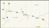
 SR 99 starts in Leupp
, Arizona
in the Navajo Indian Reservation and heads south to Interstate 40 west of Winslow
. Heading into Winslow, State Route 99 runs on a shared insight with I-40, then exiting I-40 in Winslow onto Business Loop 40 / Historic US 66 (this stretch is unsigned). In Winslow state route 99 heads south on State Route 87
beginning again south of Winslow where state route 99 separates and heads towards the edge of the Apache Forest where the state maintenance of the road ends.
in 1968 as State Route 99. A designation of the nearby State Route 377 was deleted in 1983 and added to SR 99. Since then, there have not been any major realignments of the route.
U.S. state
A U.S. state is any one of the 50 federated states of the United States of America that share sovereignty with the federal government. Because of this shared sovereignty, an American is a citizen both of the federal entity and of his or her state of domicile. Four states use the official title of...
of Arizona
Arizona
Arizona ; is a state located in the southwestern region of the United States. It is also part of the western United States and the mountain west. The capital and largest city is Phoenix...
.
Route description
Leupp, Arizona
Leupp is a census-designated place in Coconino County, Arizona, United States. The population was 970 at the 2000 census.-History:During World War II, an abandoned Bureau of Indian Affairs boarding school in Leupp was used as the Leupp Isolation Center, for Japanese American internees considered...
, Arizona
Arizona
Arizona ; is a state located in the southwestern region of the United States. It is also part of the western United States and the mountain west. The capital and largest city is Phoenix...
in the Navajo Indian Reservation and heads south to Interstate 40 west of Winslow
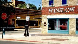
Winslow, Arizona
-Demographics:As of the census of 2000, there were 9,520 people, 2,754 households, and 1,991 families residing in the city. The population density was 773.1 people per square mile . There were 3,198 housing units at an average density of 259.7 per square mile...
. Heading into Winslow, State Route 99 runs on a shared insight with I-40, then exiting I-40 in Winslow onto Business Loop 40 / Historic US 66 (this stretch is unsigned). In Winslow state route 99 heads south on State Route 87
State Route 87 (Arizona)
State Route 87 is a north–south road that travels from SR 84 near Picacho, Arizona northward to SR 264 near Second Mesa.-Route description:The road that becomes Route 87 begins at Second Mesa, Arizona...
beginning again south of Winslow where state route 99 separates and heads towards the edge of the Apache Forest where the state maintenance of the road ends.
History
The route was defined by the Arizona Department of TransportationArizona Department of Transportation
The Arizona Department of Transportation is an Arizona state government agency charged with facilitating mobility within the state. In addition to managing the state's highway system, the agency is also involved with public transportation and municipal airports...
in 1968 as State Route 99. A designation of the nearby State Route 377 was deleted in 1983 and added to SR 99. Since then, there have not been any major realignments of the route.
Major intersections
| County | Location | Mile | Destination | Notes |
|---|---|---|---|---|
| Navajo Navajo County, Arizona -2010:Whereas according to the 2010 U.S. Census Bureau:*49.3% White*0.9% Black*43.4% Native American*0.5% Asian*0.1% Native Hawaiian or Pacific Islander*2.5% Two or more races*3.3% Other races*10.8% Hispanic or Latino -2000:... |
0.0000 | Dead end | ||
| 15.0084 | ||||
| Winslow Winslow, Arizona -Demographics:As of the census of 2000, there were 9,520 people, 2,754 households, and 1,991 families residing in the city. The population density was 773.1 people per square mile . There were 3,198 housing units at an average density of 259.7 per square mile... |
18.2531 | Begin concurrency, interchange | ||
| Coconino Coconino County, Arizona -2010:Whereas according to the 2010 U.S. Census Bureau:*61.7% White*1.2% Black*27.3% Native American*1.4% Asian*0.1% Native Hawaiian or Pacific Islander*3.1% Two or more races*5.2% Other races*13.5% Hispanic or Latino -2000:... |
24.9350 | End concurrency, interchange | ||
| Leupp Leupp, Arizona Leupp is a census-designated place in Coconino County, Arizona, United States. The population was 970 at the 2000 census.-History:During World War II, an abandoned Bureau of Indian Affairs boarding school in Leupp was used as the Leupp Isolation Center, for Japanese American internees considered... |
44.3093 | BIA Route 15 |