
Anaconda Range
Encyclopedia
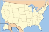
The Anaconda Range, informally known as the "Pintlars", is a group of high mountains located in southwestern Montana
, in the northwestern United States
. The mountain range takes its name from the nearby town of Anaconda
, founded by Marcus Daly
in 1883. It runs northeast approximately 50 miles (80 km) from Lost Trail Pass to a point near the community of Anaconda
, covering parts of Ravalli
, Deer Lodge
, Granite
and Beaverhead
Counties. To the northwest are the Sapphire Mountains
, to the south is the Big Hole Valley
. Due north, the range blends into the Flint Creek Range, and to the southeast lies the Big Hole River and Pioneer Mountains. The crest of the range is part of the Continental Divide
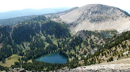
, rising to 10,793 feet (3290 m) at West Goat Peak. Other major summits include Mt. Evans (10,641 ft, 3243 m), Mt. Haggin (10,607 ft, 3233 m), Warren Peak (10,463 ft, 3189 m), and East Goat Peak (10,399 ft, 3170 m). West Pintler Peak, located in a more commonly visited area, rises to 9894 feet (2895 m). Much of the range is protected in the Anaconda-Pintler Wilderness Area
.
Montana
Montana is a state in the Western United States. The western third of Montana contains numerous mountain ranges. Smaller, "island ranges" are found in the central third of the state, for a total of 77 named ranges of the Rocky Mountains. This geographical fact is reflected in the state's name,...
, in the northwestern United States
United States
The United States of America is a federal constitutional republic comprising fifty states and a federal district...
. The mountain range takes its name from the nearby town of Anaconda
Anaconda, Montana
Anaconda, county seat of Anaconda City/Deer Lodge County, is located in mountainous southwestern Montana. The Continental Divide passes within 8 miles of the community with the local Pintler Mountain range reaching 10,379 feet...
, founded by Marcus Daly
Marcus Daly
Marcus Daly redirects here, see also Marcus Daly Marcus Daly was an Irish-born American businessman known as one of the three "Copper Kings" of Butte, Montana, United States.- Early life:...
in 1883. It runs northeast approximately 50 miles (80 km) from Lost Trail Pass to a point near the community of Anaconda
Anaconda, Montana
Anaconda, county seat of Anaconda City/Deer Lodge County, is located in mountainous southwestern Montana. The Continental Divide passes within 8 miles of the community with the local Pintler Mountain range reaching 10,379 feet...
, covering parts of Ravalli
Ravalli County, Montana
-National protected areas:*Bitterroot National Forest *Lee Metcalf National Wildlife Refuge*Lolo National Forest -Demographics:As of the census of 2000 , there were 36,070 people, 14,289 households, and 10,188 families residing in the county. The population density was 15 people per square mile...
, Deer Lodge
Deer Lodge County, Montana
-National protected areas:*Beaverhead National Forest *Deerlodge National Forest -Demographics:As of the census of 2000, there were 9,417 people, 3,995 households, and 2,524 families residing in the county. The population density was 13 people per square mile . There were 4,958 housing units at an...
, Granite
Granite County, Montana
-National protected areas:*Deerlodge National Forest *Lolo National Forest -Demographics:As of the census of 2000, there were 2,830 people, 1,200 households, and 784 families residing in the county. The population density was 2 people per square mile . There were 2,074 housing units at an average...
and Beaverhead
Beaverhead County, Montana
-National protected areas:* Beaverhead National Forest * Big Hole National Battlefield* Nez Perce National Historical Park * Red Rock Lakes National Wildlife Refuge-History:...
Counties. To the northwest are the Sapphire Mountains
Sapphire Mountains
The Sapphire Mountains are a range of mountains located in southwestern Montana in the northwestern United States. From a point near the Clark Fork River and the city of Missoula, they run in a southerly direction for a distance of approximately 60 miles , making up much of the border between...
, to the south is the Big Hole Valley
Big Hole River
The Big Hole River is a tributary of the Jefferson River, approximately 153 miles long, in southwestern Montana in the United States. It rises in Skinner lake in the Beaverhead National Forest in the Beaverhead Mountains of the Bitterroot Range at the continental divide along the...
. Due north, the range blends into the Flint Creek Range, and to the southeast lies the Big Hole River and Pioneer Mountains. The crest of the range is part of the Continental Divide
Continental Divide
The Continental Divide of the Americas, or merely the Continental Gulf of Division or Great Divide, is the name given to the principal, and largely mountainous, hydrological divide of the Americas that separates the watersheds that drain into the Pacific Ocean from those river systems that drain...
, rising to 10,793 feet (3290 m) at West Goat Peak. Other major summits include Mt. Evans (10,641 ft, 3243 m), Mt. Haggin (10,607 ft, 3233 m), Warren Peak (10,463 ft, 3189 m), and East Goat Peak (10,399 ft, 3170 m). West Pintler Peak, located in a more commonly visited area, rises to 9894 feet (2895 m). Much of the range is protected in the Anaconda-Pintler Wilderness Area
Anaconda-Pintler Wilderness
The Anaconda-Pintler Wilderness is located in southwestern Montana, in the northwestern United States. It runs for 40 miles along both sides of the crest of the Anaconda Range, covering almost 250 square miles . To the north are the Sapphire Mountains, and to the south is the Big Hole Valley...
.