
American Tobacco Trail
Encyclopedia
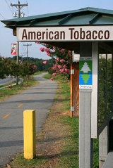
The American Tobacco Trail (ATT) is a 20 miles (32.2 km) long Rails-to-Trails project located in the Research Triangle region of North Carolina
, running along an abandoned railroad bed originally built for the American Tobacco Company
in the 1970s. The route crosses through the City of Durham
, Durham County
, Chatham County
, and Wake County
. The ATT is part of the East Coast Greenway
and is open to pedestrians, cyclists, equestrians (in non-urban sections) and other non-motorized users.
across Morehead Avenue from the Durham Bulls Athletic Park
. Trail
users may park in a gravel parking area underneath the Durham Freeway (NC 147), except on game days. The trail is a 10 feet (3 m) wide asphalt paved greenway with loose gravel shoulders. It is open to walkers, cyclists, rollerbladers and wheelchair users, but not equestrians.
The American Tobacco Trail covers 6.75 miles (10.9 km) through the City of Durham to its current end at NC Hwy. 54 just north of I-40. This segment of the ATT is a designated portion of the East Coast Greenway
. Plans are underway to construct a pedestrian bridge across I-40 between exit 274 and 276, connecting two major portions of the ATT.
 South of I-40
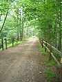
there is a 2.7 miles (4.3 km) natural or existing surface segment that is currently open. This portion, which extends from Massey Chapel Road past the Chancellor's Ridge subdivision, crosses under Fayetteville Road, crosses Scott King Road and traverses Crooked Creek, is currently under reconstruction by the Triangle Rails-to-Trails Conservancy (TRTC) under a grant from the Durham Open Space and Trails Commission. The trail may be most accessed at 7682 Fayetteville Road, Durham, NC 27713, as there is off-road parking. A short spur of the trail continues north from Massey Chapel Road and currently ends in a swamp.
and Cary
have plans to connect their municipal greenway systems to the ATT in the future. The trail terminates at a trailhead off of Ragan Rd.
In total, 13.7 miles (22 km) of continuous trail is usable in the southernmost portion and 6.75 miles (10.9 km) of continuous paved trail is usable in the northernmost portion. A traverse of approximately 2 miles (3.2 km) on public roads is required to get between these two continuous sections.
in 1890, which subsequently acquired the Lucky Strike Company
and over 200 other firms. The company built processing plants and warehouses in Durham which were served by several rail lines built in 1905. The rail line to the south which is now the ATT, connected from Durham to Bonsal, NC
and onwards to Duncan
. It was known as the New Hope Valley Railway and later Durham & South Carolina (it never got as far as SC), and later became part of the Norfolk Southern Railway
system. In the 1970s the U.S. Army Corps of Engineers built the Jordan Lake
reservoir in Chatham County
necessitating the relocation of a large portion of the tracks. A portion of the original right-of-way is presently a natural surface trail accessible off of Stagecoach Rd. in Durham. A new rail line was built on higher ground a few miles to the east. However, only about 10 years later, the tracks were removed from this new railroad as Norfolk Southern had been bought out, and trains could access the American Tobacco complex via the Southern Railway more economically. In the 1980s the Triangle Rails to Trails Conservancy (TRTC) was formed to preserve the corridor as a multi-use trail and developed a Master Plan for the ATT in 1992. Since then, work has progressed at a moderate pace to develop the trail for pedestrian, bicycle, and equestrian use.
North Carolina
North Carolina is a state located in the southeastern United States. The state borders South Carolina and Georgia to the south, Tennessee to the west and Virginia to the north. North Carolina contains 100 counties. Its capital is Raleigh, and its largest city is Charlotte...
, running along an abandoned railroad bed originally built for the American Tobacco Company
American Tobacco Company
The American Tobacco Company was a tobacco company founded in 1890 by J. B. Duke through a merger between a number of U.S. tobacco manufacturers including Allen and Ginter and Goodwin & Company...
in the 1970s. The route crosses through the City of Durham
Durham, North Carolina
Durham is a city in the U.S. state of North Carolina. It is the county seat of Durham County and also extends into Wake County. It is the fifth-largest city in the state, and the 85th-largest in the United States by population, with 228,330 residents as of the 2010 United States census...
, Durham County
Durham County, North Carolina
-Demographics:As of the census of 2000, there were 223,314 people, 89,015 households, and 54,032 families residing in the county. The population density was 769 people per square mile . There were 95,452 housing units at an average density of 329 per square mile...
, Chatham County
Chatham County, North Carolina
Chatham County is a county located in the Piedmont area of the U.S. state of North Carolina. As of 2000, the population was 49,329. Its county seat is Pittsboro.-History:...
, and Wake County
Wake County, North Carolina
Wake County is a county located in the U.S. state of North Carolina. As of the 2010 census, the population was 900,993 making it North Carolina's second most populated county...
. The ATT is part of the East Coast Greenway
East Coast Greenway
The East Coast Greenway, or ECG, is a project to create a nearly urban path linking the major cities of the Atlantic coast of the United States, from Calais, Maine, to Key West, Florida, for non-motorized human transportation...
and is open to pedestrians, cyclists, equestrians (in non-urban sections) and other non-motorized users.
Route
The American Tobacco Trail is split into three main sections, from North to South:- The completed trail in the City of Durham, part of the City greenway system
- The incomplete gap between NC Hwy. 54 and Massey Chapel Road. Plans are underway to fill this gap.
- The completed trail in southern Durham County, Chatham County, and Wake County.
City of Durham
The ATT begins in the City of DurhamDurham, North Carolina
Durham is a city in the U.S. state of North Carolina. It is the county seat of Durham County and also extends into Wake County. It is the fifth-largest city in the state, and the 85th-largest in the United States by population, with 228,330 residents as of the 2010 United States census...
across Morehead Avenue from the Durham Bulls Athletic Park
Durham Bulls Athletic Park
Durham Bulls Athletic Park, frequently called the DBAP , is a ballpark in Durham, North Carolina that is home to the Durham Bulls, the AAA affiliate of the Tampa Bay Rays of Major League Baseball. It is also home to the Duke Blue Devils and North Carolina Central Eagles college baseball teams. The...
. Trail
Trail
A trail is a path with a rough beaten or dirt/stone surface used for travel. Trails may be for use only by walkers and in some places are the main access route to remote settlements...
users may park in a gravel parking area underneath the Durham Freeway (NC 147), except on game days. The trail is a 10 feet (3 m) wide asphalt paved greenway with loose gravel shoulders. It is open to walkers, cyclists, rollerbladers and wheelchair users, but not equestrians.
The American Tobacco Trail covers 6.75 miles (10.9 km) through the City of Durham to its current end at NC Hwy. 54 just north of I-40. This segment of the ATT is a designated portion of the East Coast Greenway
East Coast Greenway
The East Coast Greenway, or ECG, is a project to create a nearly urban path linking the major cities of the Atlantic coast of the United States, from Calais, Maine, to Key West, Florida, for non-motorized human transportation...
. Plans are underway to construct a pedestrian bridge across I-40 between exit 274 and 276, connecting two major portions of the ATT.
Durham County
Interstate 40
Interstate 40 is the third-longest major east–west Interstate Highway in the United States, after I-90 and I-80. Its western end is at Interstate 15 in Barstow, California; its eastern end is at a concurrency of U.S. Route 117 and North Carolina Highway 132 in Wilmington, North Carolina...
there is a 2.7 miles (4.3 km) natural or existing surface segment that is currently open. This portion, which extends from Massey Chapel Road past the Chancellor's Ridge subdivision, crosses under Fayetteville Road, crosses Scott King Road and traverses Crooked Creek, is currently under reconstruction by the Triangle Rails-to-Trails Conservancy (TRTC) under a grant from the Durham Open Space and Trails Commission. The trail may be most accessed at 7682 Fayetteville Road, Durham, NC 27713, as there is off-road parking. A short spur of the trail continues north from Massey Chapel Road and currently ends in a swamp.
Chatham County
The ATT trail traverses 4.5 miles (7.2 km) in Chatham County. Once the trail crosses into Chatham county, the trail converts to a dual surface of asphalt and compacted screenings. The trail is open for foot, bike and equestrian use by TRTC. The trail crosses Northeast Creek and O'Kelly Chapel Road, past the Old Chatham Golf Course. It also traverses the end of Pittard Sears Road, Panther Creek, and continues past New Hope Church Road. Most street crossings allow on-road parking.Wake County
The ATT traverses 6.4 miles (10.3 km) in in Wake County, followed by a usable but unimproved 1.9 miles (3.1 km) portion. The improved greenway is approximately 10 feet (3 m) wide with a granite screening surface. The trail is open to hikers, cyclists, wheelchair users and equestrians. Users can access this portion of the greenway most conveniently at 1305 White Oak Church Road, Apex, NC 27523 or along Wimberly Rd. The towns of ApexApex, North Carolina
Apex is a town in Wake County, North Carolina and a suburb of Raleigh. The population was 37,476 according to the 2010 census., wakegov.com-Geography:Apex is located at ....
and Cary
Cary, North Carolina
Cary is a large town and suburb of Raleigh, North Carolina in Wake and Chatham counties in the U.S. state of North Carolina. Located almost entirely in Wake County, it is the second largest municipality in that county and the third largest municipality in The Triangle after Raleigh and Durham...
have plans to connect their municipal greenway systems to the ATT in the future. The trail terminates at a trailhead off of Ragan Rd.
In total, 13.7 miles (22 km) of continuous trail is usable in the southernmost portion and 6.75 miles (10.9 km) of continuous paved trail is usable in the northernmost portion. A traverse of approximately 2 miles (3.2 km) on public roads is required to get between these two continuous sections.
History
J.B. Duke founded the American Tobacco CompanyAmerican Tobacco Company
The American Tobacco Company was a tobacco company founded in 1890 by J. B. Duke through a merger between a number of U.S. tobacco manufacturers including Allen and Ginter and Goodwin & Company...
in 1890, which subsequently acquired the Lucky Strike Company
Lucky Strike
Lucky Strike is a brand of cigarette owned by the R.J. Reynolds Tobacco Company and British American Tobacco groups. Often referred to as "Luckies", Lucky Strike was the top selling cigarette in the United States during the 1930s.- History :...
and over 200 other firms. The company built processing plants and warehouses in Durham which were served by several rail lines built in 1905. The rail line to the south which is now the ATT, connected from Durham to Bonsal, NC
Bonsal, North Carolina
Bonsal is an unincorporated community in the New Hill, North Carolina postal district, part of the Extra Territorial Jurisdiction of Apex, North Carolina, in extreme southwestern Wake County, North Carolina...
and onwards to Duncan
Duncan, North Carolina
Duncan is an unincorporated community located in the Buckhorn Township of Harnett County, North Carolina .Duncan was used as major source of inspiration for the fictional town of Missing Mile, North Carolina in Poppy Z. Brite's novel Drawing Blood....
. It was known as the New Hope Valley Railway and later Durham & South Carolina (it never got as far as SC), and later became part of the Norfolk Southern Railway
Norfolk Southern Railway (former)
The Norfolk Southern Railway was the final name of a railroad running from Norfolk, Virginia southwest and west to Charlotte, North Carolina. It was acquired by the Southern Railway in 1974, which was merged with the Norfolk and Western Railway in 1990 to form the current entity of the Norfolk...
system. In the 1970s the U.S. Army Corps of Engineers built the Jordan Lake
Jordan Lake
B. Everett Jordan Lake is a reservoir located west of Raleigh and south of Durham in Chatham County, North Carolina, in the United States of America. The northernmost end of the lake actually reaches into southwestern Durham County...
reservoir in Chatham County
Chatham County, North Carolina
Chatham County is a county located in the Piedmont area of the U.S. state of North Carolina. As of 2000, the population was 49,329. Its county seat is Pittsboro.-History:...
necessitating the relocation of a large portion of the tracks. A portion of the original right-of-way is presently a natural surface trail accessible off of Stagecoach Rd. in Durham. A new rail line was built on higher ground a few miles to the east. However, only about 10 years later, the tracks were removed from this new railroad as Norfolk Southern had been bought out, and trains could access the American Tobacco complex via the Southern Railway more economically. In the 1980s the Triangle Rails to Trails Conservancy (TRTC) was formed to preserve the corridor as a multi-use trail and developed a Master Plan for the ATT in 1992. Since then, work has progressed at a moderate pace to develop the trail for pedestrian, bicycle, and equestrian use.
See also
- New Hope Valley RailwayNew Hope Valley RailwayThe New Hope Valley Railway is a heritage railroad in Bonsal, North Carolina operated by the North Carolina Railway Museum, Inc., an all-volunteer, nonprofit, and tax exempt educational and historical organization....
- tourist railroad at the south end of the ATT - Ellerbe Creek TrailEllerbe Creek TrailEllerbe Creek Trail is a pedestrian and bicycle greenway located in Durham, North Carolina. From downtown Durham, the trail runs along South Ellerbe Creek from Trinity Avenue to the corner of Washington Street and Club Boulevard. It then follows the sidewalk from Club Boulevard and Washington...
- pedestrian/bicycle greenway north of the ATT
External links
- Triangle Rails to Trails Conservancy - principal volunteer/advocacy group for the ATT
- Photographs and stories from a daily ATT bicycle commuter
- Video of entire paved and unpaved trail labeled with distances, cross streets, and other items
- Higher quality video of entire paved and unpaved trail labeled with distances, cross streets, and other items
- Annotated map of ATT from the Raleigh News and Observer, August 2, 2007
- North Carolina Rail-Trail Records, 1987-