
Alleghany, California
Encyclopedia
Alleghany is a small census-designated place
in Sierra County
, California
, United States
in the Sierra Nevada mountains. It is situated in the Gold Country
and continues to be a significant locale for gold mining
. The famous Sixteen-to-One Mine has been in operation since the days of the California Gold Rush
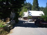
. The town is 20 miles (32.2 km) from the nearest highway (California State Route 49
) and consists largely of a single main street. The town is home to a post office, a bar (Casey's Place), and a mining museum. The population was 58 at the 2010 census.
The community was named in 1859 for the Alleghany Tunnel mine that fueled the growth of the town when it struck gold four years earlier. The mine itself was named for the Allegheny River
.
, the CDP covers an area of 0.3 square miles (0.9 km²), all of it land.
was 166.2 people per square mile (64.2/km²). The racial makeup of Alleghany was 58 (100.0%) White. Hispanic or Latino of any race were 1 persons (1.7%).
The Census reported that 58 people (100% of the population) lived in households, 0 (0%) lived in non-institutionalized group quarters, and 0 (0%) were institutionalized.
There were 27 households, out of which 5 (18.5%) had children under the age of 18 living in them, 12 (44.4%) were opposite-sex married couples
living together, 3 (11.1%) had a female householder with no husband present, 2 (7.4%) had a male householder with no wife present. There were 5 (18.5%) unmarried opposite-sex partnerships
, and 0 (0%) same-sex married couples or partnerships. 5 households (18.5%) were made up of individuals and 1 (3.7%) had someone living alone who was 65 years of age or older. The average household size was 2.15. There were 17 families
(63.0% of all households); the average family size was 2.35.
The population was spread out with 8 people (13.8%) under the age of 18, 2 people (3.4%) aged 18 to 24, 5 people (8.6%) aged 25 to 44, 36 people (62.1%) aged 45 to 64, and 7 people (12.1%) who were 65 years of age or older. The median age was 53.0 years. For every 100 females there were 123.1 males. For every 100 females age 18 and over, there were 117.4 males.
There were 40 housing units at an average density of 114.6 per square mile (44.3/km²), of which 16 (59.3%) were owner-occupied, and 11 (40.7%) were occupied by renters. The homeowner vacancy rate was 5.9%; the rental vacancy rate was 0%. 37 people (63.8% of the population) lived in owner-occupied housing units and 21 people (36.2%) lived in rental housing units.
Census-designated place
A census-designated place is a concentration of population identified by the United States Census Bureau for statistical purposes. CDPs are delineated for each decennial census as the statistical counterparts of incorporated places such as cities, towns and villages...
in Sierra County
Sierra County, California
Sierra County is a county located in the Sierra Nevada of the U.S. state of California, northeast of Sacramento on the border with Nevada. As of the 2010 census the population was 3,240, down from 3,555 at the 2000 census. The county seat is Downieville....
, California
California
California is a state located on the West Coast of the United States. It is by far the most populous U.S. state, and the third-largest by land area...
, United States
United States
The United States of America is a federal constitutional republic comprising fifty states and a federal district...
in the Sierra Nevada mountains. It is situated in the Gold Country
Gold Country
Gold Country is a region in the central and northeastern part of California, United States. It is famed for the mineral deposits and gold mines that attracted waves of immigrants, known as the 49ers, during the 1849 California Gold Rush.-Geography:State Route 49 was built through the Gold Country,...
and continues to be a significant locale for gold mining
Gold mining
Gold mining is the removal of gold from the ground. There are several techniques and processes by which gold may be extracted from the earth.-History:...
. The famous Sixteen-to-One Mine has been in operation since the days of the California Gold Rush
California Gold Rush
The California Gold Rush began on January 24, 1848, when gold was found by James W. Marshall at Sutter's Mill in Coloma, California. The first to hear confirmed information of the gold rush were the people in Oregon, the Sandwich Islands , and Latin America, who were the first to start flocking to...
. The town is 20 miles (32.2 km) from the nearest highway (California State Route 49
California State Route 49
State Route 49 is a north–south state highway in the U.S. state of California that passes through many historic mining communities of the 1849 California gold rush. Highway 49 is numbered after the "49ers", the waves of immigrants who swept into the area looking for gold, and a portion of it...
) and consists largely of a single main street. The town is home to a post office, a bar (Casey's Place), and a mining museum. The population was 58 at the 2010 census.
The community was named in 1859 for the Alleghany Tunnel mine that fueled the growth of the town when it struck gold four years earlier. The mine itself was named for the Allegheny River
Allegheny River
The Allegheny River is a principal tributary of the Ohio River; it is located in the Eastern United States. The Allegheny River joins with the Monongahela River to form the Ohio River at the "Point" of Point State Park in Downtown Pittsburgh, Pennsylvania...
.
Geography
According to the United States Census BureauUnited States Census Bureau
The United States Census Bureau is the government agency that is responsible for the United States Census. It also gathers other national demographic and economic data...
, the CDP covers an area of 0.3 square miles (0.9 km²), all of it land.
Demographics
The 2010 United States Census reported that Alleghany had a population of 58. The population densityPopulation density
Population density is a measurement of population per unit area or unit volume. It is frequently applied to living organisms, and particularly to humans...
was 166.2 people per square mile (64.2/km²). The racial makeup of Alleghany was 58 (100.0%) White. Hispanic or Latino of any race were 1 persons (1.7%).
The Census reported that 58 people (100% of the population) lived in households, 0 (0%) lived in non-institutionalized group quarters, and 0 (0%) were institutionalized.
There were 27 households, out of which 5 (18.5%) had children under the age of 18 living in them, 12 (44.4%) were opposite-sex married couples
Marriage
Marriage is a social union or legal contract between people that creates kinship. It is an institution in which interpersonal relationships, usually intimate and sexual, are acknowledged in a variety of ways, depending on the culture or subculture in which it is found...
living together, 3 (11.1%) had a female householder with no husband present, 2 (7.4%) had a male householder with no wife present. There were 5 (18.5%) unmarried opposite-sex partnerships
POSSLQ
POSSLQ is an abbreviation for "Persons of Opposite Sex Sharing Living Quarters," a term coined in the late 1970s by the United States Census Bureau as part of an effort to more accurately gauge the prevalence of cohabitation in American households....
, and 0 (0%) same-sex married couples or partnerships. 5 households (18.5%) were made up of individuals and 1 (3.7%) had someone living alone who was 65 years of age or older. The average household size was 2.15. There were 17 families
Family (U.S. Census)
A family or family household is defined by the United States Census Bureau for statistical purposes as "a householder and one or more other people related to the householder by birth, marriage, or adoption. They do not include same-sex married couples even if the marriage was performed in a state...
(63.0% of all households); the average family size was 2.35.
The population was spread out with 8 people (13.8%) under the age of 18, 2 people (3.4%) aged 18 to 24, 5 people (8.6%) aged 25 to 44, 36 people (62.1%) aged 45 to 64, and 7 people (12.1%) who were 65 years of age or older. The median age was 53.0 years. For every 100 females there were 123.1 males. For every 100 females age 18 and over, there were 117.4 males.
There were 40 housing units at an average density of 114.6 per square mile (44.3/km²), of which 16 (59.3%) were owner-occupied, and 11 (40.7%) were occupied by renters. The homeowner vacancy rate was 5.9%; the rental vacancy rate was 0%. 37 people (63.8% of the population) lived in owner-occupied housing units and 21 people (36.2%) lived in rental housing units.
Further reading
- History of Sierra County, by James J. Sinnott, vol.3: Allegheny and Forest City: Treasure Towns, published by California Traveler, Volcano, California, 1975.