

Alatna River
Encyclopedia
Alaska
Alaska is the largest state in the United States by area. It is situated in the northwest extremity of the North American continent, with Canada to the east, the Arctic Ocean to the north, and the Pacific Ocean to the west and south, with Russia further west across the Bering Strait...
. It is called one of the most beautiful rivers in the United States
United States
The United States of America is a federal constitutional republic comprising fifty states and a federal district...
. The Alatna River stems from the central Brooks Range
Brooks Range
The Brooks Range is a mountain range in far northern North America. It stretches from west to east across northern Alaska and into Canada's Yukon Territory, a total distance of about 1100 km . The mountains top out at over 2,700 m . The range is believed to be approximately 126 million years old...
flowing through the Endicott Mountains
Endicott Mountains
The Endicott Mountains are a range of mountains, part of the Brooks Range in northern Alaska. They are located in the middle of the Brooks range and run some east-west. To the east are the Philip Smith Mountains and to the west are the Schwatka Mountains...
, passing Circle Lake, the Arrigetch Peaks
Arrigetch Peaks
The Arrigetch Peaks are a cluster of rugged granite spires in the Endicott Mountains of the central Brooks Range in northern Alaska. The name Arrigetch means 'fingers of the outstretched hand' in the Inupiat language. The peaks ring the glacial cirques at the head of the Kobuk River and 2...
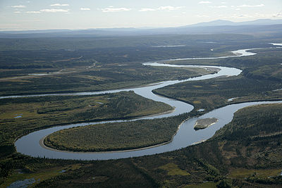
and Takahula Lake before entering the Helpmejack Hills. The last section of the river continues to flow in a SSE direction through the Alatna Hills into its confluence with the Koyukuk River
Koyukuk River
The Koyukuk River is a principal tributary of the Yukon River, approximately 500 mi long, in northern Alaska in the United States.It drains an area north of the Yukon on the southern side of the Brooks Range...
near the small village of Allakaket. The first 25 miles (40.2 km) of the Alatna are shallow and rocky, followed by 15 miles (24.1 km) of a continued shallow area with more rapids. The river then mellows out near Takahula and Circle Lake becoming deeper and more meandering while the scenery turns from mountain peaks into hilly boreal forest. According to The Alaska River Guide, this river is 184 miles (296.1 km) long from the headwaters to Allakaket and 137 miles (220.5 km) from Circle Lake to Allakaket.
The river is very popular for float trips due to its calm flow and wonderful scenery. Float trips usually take from four to fourteen days, depending on put-in spot and pick-up spot, and also weather/river conditions. One common place to put in is Circle Lake, a small lake which is float plane accessible and is located in a beautiful part of the valley. Another place to put in is Takahula Lake, a larger, float-plane accessible lake, further downstream from Circle Lake. Gaedeke Lake is also a possible put in spot, but according to the Alaska River Guide, this upstream section near the headwaters of the river is shallow and rocky making portaging or lining necessary. Most floaters take out at the village of Allakaket.
External links
- Gates Of The Arctic National Park and Preserve
- Alatna River Information from the American Whitewater organization