

Al-Qurn
Encyclopedia
Nile
The Nile is a major north-flowing river in North Africa, generally regarded as the longest river in the world. It is long. It runs through the ten countries of Sudan, South Sudan, Burundi, Rwanda, Democratic Republic of the Congo, Tanzania, Kenya, Ethiopia, Uganda and Egypt.The Nile has two major...
, opposite Thebes
Thebes, Egypt
Thebes is the Greek name for a city in Ancient Egypt located about 800 km south of the Mediterranean, on the east bank of the river Nile within the modern city of Luxor. The Theban Necropolis is situated nearby on the west bank of the Nile.-History:...
, modern Luxor
Luxor
Luxor is a city in Upper Egypt and the capital of Luxor Governorate. The population numbers 487,896 , with an area of approximately . As the site of the Ancient Egyptian city of Thebes, Luxor has frequently been characterized as the "world's greatest open air museum", as the ruins of the temple...
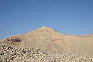
, the peak of Al-Qurn, el-Qorn the horn is the modern name for the highest point (420m) in the Theban Hills. Its ancient name was Ta Dehent, or 'the peak'. It has an almost pyramidal shape when viewed from the entrance to the Valley of the Kings
Valley of the Kings
The Valley of the Kings , less often called the Valley of the Gates of the Kings , is a valley in Egypt where, for a period of nearly 500 years from the 16th to 11th century BC, tombs were constructed for the Pharaohs and powerful nobles of the New Kingdom .The valley stands on the west bank of...
, and therefore some Egyptologists believe it may have been the reason for choosing the location as a Royal Necropolis.
The area was associated with the goddess Hathor
Hathor
Hathor , is an Ancient Egyptian goddess who personified the principles of love, beauty, music, motherhood and joy. She was one of the most important and popular deities throughout the history of Ancient Egypt...
and also the serpent goddess Meretseger
Meretseger
In Egyptian mythology, Meretseger , meaning "she who loves silence" exerted great authority during the New Kingdom era over the Theban Necropolis and was considered to be both a dangerous and merciful goddess...
: as known, cobra spreads its hood when it prepares for attack. Near the highest point one can see a plate shaped rock formation pointing out a few meters from the side of the hill. It is very easy to see as a spread hood of a cobra.
The peak can be reached on foot from two directions, starting the climbing from the Valley of the Kings or near Deir el-Medina. The climbing takes an hour - an hour and a half and the same time to get back.
The Deir el-Medina route is easier in that sense that 75% of the route is laid with concrete stairs, but on the other hand the rest 25% may be a bit more difficult so that at one point even hands must be used in climbing (still, no specific climbing skills are needed and it is suitable for the elderly). Two manned guarding posts (buildings) are located on the Deir el-Medina route that adds safety. The cobra shaped rock formation is on the Deir el-Medina route but it can easily be reached from both directions.
Click here to see a low quality panorama video clip shot from the top