
Akraberg
Encyclopedia

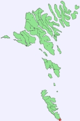
Suðuroy
Suðuroy is the southernmost of the Faroe Islands. The island covers 163.7 km². In 2010 there were 4763 inhabitants, but there has been a gradual decline in the population numbers ever since the 1950s....
, 5 km south from the village Sumba, Faroe Islands
Sumba, Faroe Islands
Sumba is the southernmost place of the Faroe Islands on the island of Suðuroy. It is located in the Sumbiar municipality.The municipality has 385 inhabitants. 258 of these people are living in Sumba. The other villages in the Municipality of Sumba are: Lopra , Akrar , Víkarbyrgi .Sumba is known for...
. The name Akraberg derives from akur (cereal field). Five kilometres south of Akraberg is the southernmost point of The Faroe Islands, a rock called Munkurin
Munkurin
Munkurin is the southernmost point of the Faroe Islands. Munkurin is an 11 metre high rock, also known as Sumbiarsteinur. Munkur means Monk. The rock is one of a group of skerries, called Flesjarnar, 5 km south of the island Suðuroy in the Faroe Islands. The sound between Flesjarnar and...
(The Monk), also called Sumbiarsteinur, which is one of a group of six rocks. This group of rocks are called Flesjarnar. The sound between Suðuroy and Munkurin is notorious for its strong current, it is called Røstin, the poet Poul F. Joensen (born 1898, died 1970) mentioned it in one of his poems "...Røstin rísin rann...".
The Lighthouse
In 1909, a lighthouse and some family houses were built in Akraberg. The lighthouse itself is 14m tall, it consists of a white cylindrical tower with red landtern roof. It was fitted with guy wires to withstand the wind drag on this southern headland. The focal plane is located at 94 m above sea level, a flash signal is given every 20 seconds with red, green and white sectors. If needed, a fog horn may be sounded every 60 seconds.Today, there are only two houses and a lighthouse, but there are no inhabitants. The last family who lived there was the lighthouse keeper Hans Petur Kjærbo and his family. They lived there during a terrible hurricane in December 1988, which later has been called The Christmas Hurricane. Luckily the house was very strong built and didn't get blasted away by the strong wind. But much damage had been done on their car, the soil and parts of the house; a window was blown out. Much damage happened in the Faroe Islands
Faroe Islands
The Faroe Islands are an island group situated between the Norwegian Sea and the North Atlantic Ocean, approximately halfway between Scotland and Iceland. The Faroe Islands are a self-governing territory within the Kingdom of Denmark, along with Denmark proper and Greenland...
that night, many houses were blasted away by the hurricane. After that the lighthouse keeper and his family moved away from Akraberg, and nobody has lived there since then, except for tourists who rent one of the two houses there. The lighthouse is now automatic, but it needs attention regularly. Hans Petur Kjærbo is still a lighthouse keeper, but now he workes not only in Akraberg but also attends most of the other lighthouses in the Faroe Islands
Faroe Islands
The Faroe Islands are an island group situated between the Norwegian Sea and the North Atlantic Ocean, approximately halfway between Scotland and Iceland. The Faroe Islands are a self-governing territory within the Kingdom of Denmark, along with Denmark proper and Greenland...
.
Medium Wave Station
Near Akraberg stands the medium wave station of Kringvarp Føroya, the Faroese broadcasting network. This transmits on 531 kHz.The antenna consists of a 141 metres tall guyed mast and can be received also in parts of Northern and Western Europe.
A Peatland Landscape
The peatland landscape above the headland of Akraberg at the southern tip of Suðuroy features relict peat cuttings of various age – from the 1950s and perhaps centuries before – as well as mounds of peat. The removal of dried peat from the torvløð and the continued use of the platforms led to a gradual increase in torvlað height. General comparisons are made with peat mounds from the British Isles.These features are of unknown antiquity, but they have been associated with the possible pre-Viking precence of Irish monks or priests (papar).
History
The Friesian People
A FrisianFriesland
Friesland is a province in the north of the Netherlands and part of the ancient region of Frisia.Until the end of 1996, the province bore Friesland as its official name. In 1997 this Dutch name lost its official status to the Frisian Fryslân...
colony was there from the year 1040 until The Black Death
Black Death
The Black Death was one of the most devastating pandemics in human history, peaking in Europe between 1348 and 1350. Of several competing theories, the dominant explanation for the Black Death is the plague theory, which attributes the outbreak to the bacterium Yersinia pestis. Thought to have...
killed all of them or most of them in 1350. The Frisians remained heathen a long time after the rest of the Faroe Islands were Christianize. It is said that they partly lived by piracy and they are mentioned in several Faeroese legends.
World War II in Akraberg
During World War II, Akraberg lighthouse and radio were serviced by technical Royal Air ForceRoyal Air Force
The Royal Air Force is the aerial warfare service branch of the British Armed Forces. Formed on 1 April 1918, it is the oldest independent air force in the world...
soldiers, working on one of the first radar
Radar
Radar is an object-detection system which uses radio waves to determine the range, altitude, direction, or speed of objects. It can be used to detect aircraft, ships, spacecraft, guided missiles, motor vehicles, weather formations, and terrain. The radar dish or antenna transmits pulses of radio...
stations, which scanned the water and air south of the Faroe Islands. There are still some buildings in Akraberg from the World War II period, which were built by the British soldiers by armed concrete.
External links
- Flickr photo set of Akraberg
- Visitsuduroy.fo
- Amateur Radio Lighthouse Society
- SkyscraperPage Forum
- BBC – WW2 people's War. Akraberg and the lighthouse are mentioned in the article.
- 360º panorama taken from near the lighthouse
- Kringvarp Føroya (Faroes Broadcasting)