

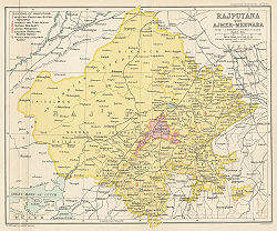
Ajmer-Merwara
Encyclopedia
Ajmer region
Ajmer is a historical region in central Rajasthan, a central part of a big Chauhan empire in 11-12th centuries.The region includes a present day Ajmer district and is bounded on the west by Marwar, on the northeast by Dhundhar, on the southeast by Hadoti, and on the south by Mewar regions.-Rule of...
. The territory of the province was ceded to the British by Daulat Rao Sindhia by a treaty on June 25, 1818.
The province consisted of the district
District
Districts are a type of administrative division, in some countries managed by a local government. They vary greatly in size, spanning entire regions or counties, several municipalities, or subdivisions of municipalities.-Austria:...
s of Ajmer
Ajmer district
Ajmer District is a district of the state of Rajasthan in western India. The city of Ajmer is the district headquarters.Ajmer District has an area of 8,481 km², and a population of 2,180,526 ,Three main groups are; Hindu 1,869,044, Muslim 244,341, Jains 47,812...
and Merwara, which were physically separated by the territory of Rajputana
Rajputana
Rājputāna was the pre-1949 name of the present-day Indian state of Rājasthān, the largest state of the Republic of India in terms of area. George Thomas was the first in 1800 A.D., to term this region as Rajputana...
Agency. Ajmer-Merwara was administered directly by the British Raj, by a chief commissioner who was subordinate to the Governor-General of India
Governor-General of India
The Governor-General of India was the head of the British administration in India, and later, after Indian independence, the representative of the monarch and de facto head of state. The office was created in 1773, with the title of Governor-General of the Presidency of Fort William...
's agent for Rajputana. Rajputana was made up of princely states, ruled by local nobles who acknowledged British sovereignty (now the majority of this region is in Rajasthan
Rajasthan
Rājasthān the land of Rajasthanis, , is the largest state of the Republic of India by area. It is located in the northwest of India. It encompasses most of the area of the large, inhospitable Great Indian Desert , which has an edge paralleling the Sutlej-Indus river valley along its border with...
state within independent India
India
India , officially the Republic of India , is a country in South Asia. It is the seventh-largest country by geographical area, the second-most populous country with over 1.2 billion people, and the most populous democracy in the world...
). Ajmer-Merwara remained a province of India from independence in 1947 to 1950, when it became the state of Ajmer
Ajmer
Ajmer , formerly written as Ajmere, is a city in Ajmer District in Rajasthan state in India. Ajmer has a population of around 800,000 , and is located west of the Rajasthan state capital Jaipur, 200 km from Jodhpur, 274 km from Udaipur, 439 km from Jaisalmer, and 391 km from...
. Ajmer state was merged into Rajputana on November 1, 1956.
The area of the province was 2710 square miles (7,018.9 km²). The plateau, on whose centre stands the town of Ajmer, may be considered as the highest point in the plains of North India
North India
North India, known natively as Uttar Bhārat or Shumālī Hindustān , is a loosely defined region in the northern part of India. The exact meaning of the term varies by usage...
; from the circle of hills which hem it in, the country slopes away on every side - towards river valleys on the east, south, west and towards the Thar Desert
Thar Desert
The Thar Desert |Punjab]] province. The Cholistan Desert adjoins the Thar desert spreading into Pakistani Punjab province.-Location and description:...
region on the north.
The Aravalli Range
Aravalli Range
The Aravalli Range literally meaning 'line of peaks', is a range of mountains in western India and eastern Pakistan running approximately 800 km from northeast to southwest across states of Rajasthan, Haryana, and Gujarat and Pakistani provinces of Punjab and Sindh...
is the distinguishing feature of the district. The range of hills which runs between Ajmer and Nasirabad
Nasirabad
Nasirabad may refer to:* Mymensingh Town, the former name of Mymensingh Town, Bangladesh* Nasirabad, India in Rajasthan, India* Nasirabad, Raibareli in Uttar Pradesh, India* Nasirabad, Ardabil, Iran* Nasirabad, alternate name of Nasrabad, Isfahan, Iran...
marks the watershed of the continent of India
India
India , officially the Republic of India , is a country in South Asia. It is the seventh-largest country by geographical area, the second-most populous country with over 1.2 billion people, and the most populous democracy in the world...
. The rain which falls on the southeastern slopes drains into the Chambal
Chambal River
The Chambal River is a tributary of the Yamuna River in central India, and forms part of the greater Gangetic drainage system. The river flows north-northeast through Madhya Pradesh, running for a time through Rajasthan, then forming the boundary between Rajasthan and Madhya Pradesh before turning...
, and so into the Bay of Bengal
Bay of Bengal
The Bay of Bengal , the largest bay in the world, forms the northeastern part of the Indian Ocean. It resembles a triangle in shape, and is bordered mostly by the Eastern Coast of India, southern coast of Bangladesh and Sri Lanka to the west and Burma and the Andaman and Nicobar Islands to the...
; that which falls on the northwest side into the Luni River
Luni River
The Luni is a river of western Rajasthan state, India. It originates in the Pushkar valley of the Aravalli Range, near Ajmer and ends in the marshy lands of Rann of Kutch in Gujarat, after travelling a distance of 530 km...
, which discharges itself into the Rann of Kutch
Rann of Kutch
The Great Rann of Kutch, also called Greater Rann of Kutch or just Rann of Kutch , is a seasonal salt marsh located in the Thar Desert in the Kutch District of Gujarat, India and the Sindh province of Pakistan....
.
The province is on the border of what may be called the arid zone; it is the debatable land between the north-eastern and south-western monsoon
Monsoon
Monsoon is traditionally defined as a seasonal reversing wind accompanied by corresponding changes in precipitation, but is now used to describe seasonal changes in atmospheric circulation and precipitation associated with the asymmetric heating of land and sea...
s, and beyond the influence of either. The south-west monsoon sweeps up the Narmada
Narmada River
The Narmada , also called Rewa is a river in central India and the fifth largest river in the Indian subcontinent. It is the third largest river that completely flows within India after Ganges and Godavari...
valley from Bombay and crossing the tableland at Neemuch
Neemuch
Neemuch or Nimach is a town in the Malwa region in state of Madhya Pradesh, India. Neemuch shares its north eastern border with state of Rajasthan. It is the administrative headquarters of Neemuch District. Nimach is an abbreviation of "North India Mounted Artillery & Cavalry Headquarters"...
gives copious supplies to Malwa, Jhalawar
Jhalawar
Jhalawar is a city in southeastern Rajasthan. It was the capital of the former princely state of Jhalawar, and is the administrative headquarters of Jhalawar District. Jhalawar was once known as Brijnagar .-Jhalawar town:...
and Kota
Kota, Rajasthan
Kota , formerly known as Kotah, is a city in the northern Indian state of Rajasthan. It is located south of state capital, Jaipur. Situated on the banks of Chambal River, the city is the trade centre for an area in which millet, wheat, rice, pulses, coriander and oilseeds are grown; industries...
and the countries which lie in the course of the Chambal River.
The clouds which strike Kathiawar
Kathiawar
Kathiawar or Kathiawad is a peninsula in western India, which is part of the Saurashtra region on the Arabian Sea coast of Gujarat state. It is bounded on the north by the great wetland of the Rann of Kutch, on the northwest by the Gulf of Kutch, on the west and south by the Arabian Sea, and on...
and Kutch are deprived of a great deal of their moisture by the hills in those countries (now the majority of this region is in Gujarat state within independent India
India
India , officially the Republic of India , is a country in South Asia. It is the seventh-largest country by geographical area, the second-most populous country with over 1.2 billion people, and the most populous democracy in the world...
), and the greater part of the remainder is deposited on Mount Abu and the higher slopes of the Aravalli Range, leaving but little for Merwara, where the hills are lower, and still less for Ajmer. It is only when the monsoon is in considerable force that Merwara gets a plentiful supply from it. The north-eastern monsoon sweeps up the valley of the Ganges from the Bay of Bengal and waters the northern part of Rajasthan, but hardly penetrates farther west than the longitude of Ajmer.
On the varying strength of these two monsoons the rainfall of the district depends. The agriculturist of Ajmer-Merwara could never rely upon two good harvests in succession.
Before Indian independence, Rajputs, Jats, the Kathats, Cheetas and Rawat Rajputs were land-holders, as well as cultivators too. Thakurs being the title of Rajputs and Rawat-Rajputs, e.g., Thakur of Masuda and Thakur of Kharwa were the prominent Rajput Thikanas of the Mertia clan, Khan being the title of Merat Rajputs,e.g., The Khan Of Athun, a major Thikana of kathat clan, Thakur of Diver, a major Thikana of Rawats. Chaudhry, the title used by Jats as village chieftans. The Rajasthan Land Reforms and Resumption of Jagirs Act, 1952 was the landmark in the legal history of land reforms in Rajasthan which was followed by Rajasthan Tenancy Act, 1955 that became applicable to the whole of Rajasthan. The overriding effect of this Act provided relief to the existing tenants and the rights accrued to tenants accordingly. Now the Jats are major land holders in the region. In ancient days Mair Gurjars were the dominant inhabitants who were defeated by the Chauhan Kings Rao Anoop and Rao Anhal whose descendents namely the Rawat-Thakurs and Cheeta-Kathat are the dominant group here. This can be seen by the clout that these castes have on the politics of this region.
See also
- Rawat RajputsRawat RajputsRawat Rajputs are a group of people who reside in Ajmer, Ballabgarh, Faridabad, Palwal Rajsamand, Bhilwara, Chittorgarh and Pali districts of Rajasthan, the area known as Magra-Merwara and the Kumaon division and Garhwal Divisions of Uttarakhand, India....
- The MersMersThe Mer population of Kathiawar region in Saurashtra also known as the Maher, Mihir, Mair or Mehr are a community of people who have evolved from the Kshatriya Rajput varna within Hinduism. They are believed to be of Indo-Aryan descent, and have a rich and diverse history involving many battles,...
are a Hindu caste from the Gujarat and Central India who originally immigrated hundred of years ago from Ajmer-Merwara and the surrounding regions of Rajputana. - Mair RajputsMair RajputsThe Mair are a Sunar caste found in northern India, which identify themselves as Mair Rajputs.Though they are the traditional goldsmiths of North India, now many are also landowners, involved in cultivation, as well as selling grocery. But their main occupation remains the manufacture and selling...
of PunjabPunjab regionThe Punjab , also spelled Panjab |water]]s"), is a geographical region straddling the border between Pakistan and India which includes Punjab province in Pakistan and the states of the Punjab, Haryana, Himachal Pradesh, Chandigarh and some northern parts of the National Capital Territory of Delhi...
are a Hindu caste who originally immigrated hundreds of years ago to Punjab from Ajmer-Merwara and the surrounding regions of Rajputana.