

AirNav Systems RadarBox
Encyclopedia
Radar
Radar is an object-detection system which uses radio waves to determine the range, altitude, direction, or speed of objects. It can be used to detect aircraft, ships, spacecraft, guided missiles, motor vehicles, weather formations, and terrain. The radar dish or antenna transmits pulses of radio...
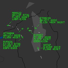
screen. A small receiver connects to the PC via USB and aircraft are detected using the small supplied antenna. By decoding ADS-B (Automatic Dependent Surveillance Broadcast) transmissions from aircraft, those aircraft are displayed on a computer in a similar display to that used by Air Traffic Control
Air traffic control
Air traffic control is a service provided by ground-based controllers who direct aircraft on the ground and in the air. The primary purpose of ATC systems worldwide is to separate aircraft to prevent collisions, to organize and expedite the flow of traffic, and to provide information and other...
. Flight number, aircraft type, altitude, heading, speed are visible and updated every second. The RadarBox system can be used at any location, either as a stand-alone system, or connected to the Internet
Internet
The Internet is a global system of interconnected computer networks that use the standard Internet protocol suite to serve billions of users worldwide...
which allows additional functions. An internal map database provides 3D multi-window maps with worldwide coverage and geographic points which include airports, runways, VOR
VHF omnidirectional range
VOR, short for VHF omnidirectional radio range, is a type of radio navigation system for aircraft. A VOR ground station broadcasts a VHF radio composite signal including the station's identifier, voice , and navigation signal. The identifier is typically a two- or three-letter string in Morse code...
, NDB
Non-directional beacon
A non-directional beacon is a radio transmitter at a known location, used as an aviation or marine navigational aid. As the name implies, the signal transmitted does not include inherent directional information, in contrast to other navigational aids such as low frequency radio range, VHF...
, Fixes, cities, roads, airways and elevation data.
RadarBox Network
When the PC running the RadarBox software is connected to the InternetInternet
The Internet is a global system of interconnected computer networks that use the standard Internet protocol suite to serve billions of users worldwide...
, the RadarBox Network
Telecommunications network
A telecommunications network is a collection of terminals, links and nodes which connect together to enable telecommunication between users of the terminals. Networks may use circuit switching or message switching. Each terminal in the network must have a unique address so messages or connections...
function is available. This allows viewing of data received by other RadarBox users all over the world. Network data is delayed by 5 minutes by default, but real-time Network data is also available.