
Acandí
Encyclopedia
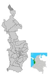
Acandí is a town and municipality in the Chocó Department
, Colombia
by the Caribbean sea
.
The municipality of Acandí was created on August 5, 1908 by ordenance of this same year.
in the northeaster part of the Gulf of Urabá
Some 558 km away from the capital Quibdó
. The municipality has an area of 869 km² and borders to the north with the Caribbean sea, to the south with the municipality of Unguía
and to the west with the Republic of Panama.
and informal commerce. The main agricultural products are maize
, plantain
and yuca
. The municipality also covers the tourism hub Capurganá
, located near the border with Panama
.
is also used as a fluvial way of transportation and a way to reach the Department capital Quibdó
. Has one small airfield that can receive light planes and it's used to primarily fly to Quibdó or towns in the Antioquia Department
. Inhabitants also use the nearby airfields in Capurganá
Alcides Fernández Airport
- (Airport class G. longitude of 1,200 m, 10 m wide and its owned by the Colombian government agency INCORA.
Capurganá Airport - Airport class F. located in the police inspection of Capurganá. Has a longitude of 852 m, 12 m wide and it is operate by the municipality
El Gilcal Airport- Airport class G. Has a longitude of 500 m, 15 m wide and it is owned by the municipality.
Chocó Department
Chocó is a department of Colombia known for its large Afro-Colombian population. It is in the west of the country, and is the only Colombian department to have coastlines on both the Pacific Ocean and the Atlantic Ocean. It also has all of Colombia's border with Panama. Its capital is...
, Colombia
Colombia
Colombia, officially the Republic of Colombia , is a unitary constitutional republic comprising thirty-two departments. The country is located in northwestern South America, bordered to the east by Venezuela and Brazil; to the south by Ecuador and Peru; to the north by the Caribbean Sea; to the...
by the Caribbean sea
Caribbean Sea
The Caribbean Sea is a sea of the Atlantic Ocean located in the tropics of the Western hemisphere. It is bounded by Mexico and Central America to the west and southwest, to the north by the Greater Antilles, and to the east by the Lesser Antilles....
.
History
The name Acandí derives from the Acandí tribe which means "River of Stones". The first foundation of the town of Acandí originated in c. 1890 by Spanish settlers Concepcion Gomez, Fermin Avila, Jose Piestan, Jose Garrido and others with the name of San Nicolas de Titumate and was located to the left margin of the Acandí River but was constantly flooded and devastated by this river. The inhabitants moved the village to a nearby safer pleace in 1896.The municipality of Acandí was created on August 5, 1908 by ordenance of this same year.
Geography and climate
Its urban area is located by the Caribbean seaCaribbean Sea
The Caribbean Sea is a sea of the Atlantic Ocean located in the tropics of the Western hemisphere. It is bounded by Mexico and Central America to the west and southwest, to the north by the Greater Antilles, and to the east by the Lesser Antilles....
in the northeaster part of the Gulf of Urabá
Gulf of Urabá
The Gulf of Urabá is a gulf on the northern coast of South America. It is part of the Caribbean Sea. It is a long narrow inlet in the coast of Colombia, close to the connection of the continent to the Isthmus of Panama. The town of Turbo lies at the southern end of the Gulf...
Some 558 km away from the capital Quibdó
Quibdó
Quibdó is the capital city of Chocó Department, in western Colombia. The municipality of Quibdó has an area of 3,337.5 km² and a population of 100,000 mainly consisting of Afro Colombians and Zambo Colombians. Quibdo serves a a receptor for those persons affected by the Colombian armed...
. The municipality has an area of 869 km² and borders to the north with the Caribbean sea, to the south with the municipality of Unguía
Unguía
Unguía is a municipality and town in the Chocó Department, Colombia....
and to the west with the Republic of Panama.
Economy
The main economic activities of Acandí are agriculture, livestock raising, artisan fishingArtisan fishing
Artisan fishing is a term used to describe small scale low-technology commercial or subsistence fishing practices. The term particularly applies to coastal or island ethnic groups using traditional techniques such as rod and tackle, arrows and harpoons, throw nets and drag nets, and traditional...
and informal commerce. The main agricultural products are maize
Maize
Maize known in many English-speaking countries as corn or mielie/mealie, is a grain domesticated by indigenous peoples in Mesoamerica in prehistoric times. The leafy stalk produces ears which contain seeds called kernels. Though technically a grain, maize kernels are used in cooking as a vegetable...
, plantain
Plantain
Plantain is the common name for herbaceous plants of the genus Musa. The fruit they produce is generally used for cooking, in contrast to the soft, sweet banana...
and yuca
Cassava
Cassava , also called yuca or manioc, a woody shrub of the Euphorbiaceae native to South America, is extensively cultivated as an annual crop in tropical and subtropical regions for its edible starchy tuberous root, a major source of carbohydrates...
. The municipality also covers the tourism hub Capurganá
Capurganá
Capurganá is a township in the municipality of Acandí in Chocó, Colombia. Located on the Gulf of Uraba it is a crossing point to enter Panama, and has an immigration office of the Departamento Administrativo de Seguridad of Colombia...
, located near the border with Panama
Panama
Panama , officially the Republic of Panama , is the southernmost country of Central America. Situated on the isthmus connecting North and South America, it is bordered by Costa Rica to the northwest, Colombia to the southeast, the Caribbean Sea to the north and the Pacific Ocean to the south. The...
.
Transportation
Acandí is a maritime small port over the Caribbean sea mainly utilizing it to communicate with other nearby ports of Colombia and Panama. The Atrato RiverAtrato River
The Río Atrato is a river of northwestern Colombia. It rises in the slopes of the Western Cordillera and flows almost due north to the Gulf of Urabá , where it forms a large, swampy delta....
is also used as a fluvial way of transportation and a way to reach the Department capital Quibdó
Quibdó
Quibdó is the capital city of Chocó Department, in western Colombia. The municipality of Quibdó has an area of 3,337.5 km² and a population of 100,000 mainly consisting of Afro Colombians and Zambo Colombians. Quibdo serves a a receptor for those persons affected by the Colombian armed...
. Has one small airfield that can receive light planes and it's used to primarily fly to Quibdó or towns in the Antioquia Department
Antioquia Department
Antioquia is one of the 32 departments of Colombia, located in the central northwestern part of Colombia with a narrow section that borders the Caribbean Sea. Most of its territory is mountainous with some valleys, much of which is part of the Andes mountain range...
. Inhabitants also use the nearby airfields in Capurganá
Alcides Fernández Airport
Alcides Fernández Airport
Alcides Fernández Airport is a commercial airport on the Caribbean coast of Colombia serving to town of Acandí. The airport is considered by residents of the town of Acandí to be an important link between that community and the rest of Colombia as well as neighboring Panama.The airport was closed...
- (Airport class G. longitude of 1,200 m, 10 m wide and its owned by the Colombian government agency INCORA.
Capurganá Airport - Airport class F. located in the police inspection of Capurganá. Has a longitude of 852 m, 12 m wide and it is operate by the municipality
El Gilcal Airport- Airport class G. Has a longitude of 500 m, 15 m wide and it is owned by the municipality.