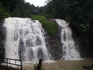
Abbey Falls
Encyclopedia

Kodagu
Kodagu , also known by its anglicised former name of Coorg, is an administrative district in Karnataka, India. It occupies an area of in the Western Ghats of southwestern Karnataka. As of 2001, the population was 548,561, 13.74% of which resided in the district's urban centres, making it the least...
, in the Western Ghats
Western Ghats
The Western Ghats, Western Ghauts or the Sahyādri is a mountain range along the western side of India. It runs north to south along the western edge of the Deccan Plateau, and separates the plateau from a narrow coastal plain along the Arabian Sea. The Western Ghats block rainfall to the Deccan...
in Karnataka
Karnataka
Karnataka , the land of the Kannadigas, is a state in South West India. It was created on 1 November 1956, with the passing of the States Reorganisation Act and this day is annually celebrated as Karnataka Rajyotsava...
, India
India
India , officially the Republic of India , is a country in South Asia. It is the seventh-largest country by geographical area, the second-most populous country with over 1.2 billion people, and the most populous democracy in the world...
. It is located 8 km from the town of Madikeri and 268 km from Bangalore
Bangalore
Bengaluru , formerly called Bengaluru is the capital of the Indian state of Karnataka. Bangalore is nicknamed the Garden City and was once called a pensioner's paradise. Located on the Deccan Plateau in the south-eastern part of Karnataka, Bangalore is India's third most populous city and...
.
The waterfalls
In the mountains of the Western GhatsWestern Ghats
The Western Ghats, Western Ghauts or the Sahyādri is a mountain range along the western side of India. It runs north to south along the western edge of the Deccan Plateau, and separates the plateau from a narrow coastal plain along the Arabian Sea. The Western Ghats block rainfall to the Deccan...
, several streams combine, swelling with the monsoon rains and plunging down the mountain slope at enormous speed, hitting the huge boulders hard and forcing through the crevices and ravines. A misty cloud hangs over the falls. From here the water flows into the Kaveri River
Kaveri River
The Kaveri , also spelled Cauvery in English, is a large Indian river. The origin of the river is traditionally placed at Talakaveri, Kodagu in the Western Ghats in Karnataka, flows generally south and east through Karnataka and Tamil Nadu and across the southern Deccan plateau through the...
. During the monsoon season the water flow is very high. During the dry seasons the flow is considerably diminished.One can find a lot of leeches inside the water.
The waterfall is located between private coffee plantations with stocky coffee bushes and spice estates with trees entwined with pepper vines. The falls appear suddenly, the water cascading over rocks into calm pools.
A hanging bridge
Hanging Bridge
Hanging Bridge is a medieval bridge spanning the Hanging Ditch, which connected the rivers Irk and Irwell in Manchester, England. The first reference to the bridge was in 1343, when it was called Hengand Brigge, but the present structure was built in 1421, replacing an earlier bridge. Material...
constructed just opposite the falls comes in handy for the Tourists.
There is a Kali Mata temple on the other side of the bridge and Coffee and Black Pepper trees on the other side.
Transport
Madikeri is 250 km from BangaloreBangalore
Bengaluru , formerly called Bengaluru is the capital of the Indian state of Karnataka. Bangalore is nicknamed the Garden City and was once called a pensioner's paradise. Located on the Deccan Plateau in the south-eastern part of Karnataka, Bangalore is India's third most populous city and...
and 90 km from nearest airport in Mangalore
Mangalore
Mangalore is the chief port city of the Indian state of Karnataka. It is located about west of the state capital, Bangalore. Mangalore lies between the Arabian Sea and the Western Ghat mountain ranges, and is the administrative headquarters of the Dakshina Kannada district in south western...
.
From Madikeri the falls are accessible by a narrow road to the coffee estate. A path through coffee and cardamom plantations leads to the waterfalls. The roar of the falls can be heard from the road. The best time to visit is early winter when the monsoons have brought plenty of water.

