
1912 Atlantic hurricane season
Encyclopedia
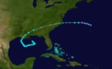
The 1912 Atlantic hurricane season ran through the summer and the first half of fall in 1912. The hurricane season was fairly quiet. Only 6 tropical systems formed during the season. Four of those became hurricanes and just one became a major hurricane.
and peaked as a tropical storm. It made landfall near Intracoastal City, Louisiana
. Damage was minimal.
. Damage was minimal.
and made landfall as a weak hurricane near Pascagoula, Mississippi
. A man was killed and damage came to $39,000 (1912 dollars).
. It quickly became a hurricane and reached Category 2
strength right before landfall near Cancún
, Mexico
. It passed over the Yucatán Peninsula
and made landfall again just south of Corpus Christi, Texas
as a Category 1
. 15 people died and damage came to over $28,000.
hurricane that moved very slowly across the island of Jamaica
. It had formed in November north of Panama
and strengthened slowly. It crawled up to Jamaica with sustained winds of 115 mph (185 km/h) and moved slowly across the island. 100 people were killed from flooding and heavy rainfall.
Tropical Storm One
The first storm formed on June 7. It formed in the Gulf of MexicoGulf of Mexico
The Gulf of Mexico is a partially landlocked ocean basin largely surrounded by the North American continent and the island of Cuba. It is bounded on the northeast, north and northwest by the Gulf Coast of the United States, on the southwest and south by Mexico, and on the southeast by Cuba. In...
and peaked as a tropical storm. It made landfall near Intracoastal City, Louisiana
Intracoastal City, Louisiana
Intracoastal City is an unincorporated community in Vermilion Parish, Louisiana, United States. It is situated on the west bank of the Vermilion River at its junction with the Gulf Intracoastal Waterway and has various port facilities and some permanent residents.Intracoastal City is approximately...
. Damage was minimal.
Tropical Storm Two
A weak tropical storm struck Brunswick, GeorgiaBrunswick, Georgia
Brunswick is the major urban and economic center in southeastern Georgia in the United States. The municipality is located on a harbor near the Atlantic Ocean, approximately 30 miles north of Florida and 70 miles south of South Carolina. Brunswick is bordered on the east by the Atlantic...
. Damage was minimal.
Tropical Storm Three
On September 2, a tropical storm developed offshore North Carolina, Initially moving south, it turned toward the west and made landfall in south Georgia as a tropical depression. It dissipated the next day. Damage is unknown.Hurricane Four
The first hurricane of the season formed in September in Apalachee BayApalachee Bay
Apalachee Bay is a bay in the northeastern Gulf of Mexico occupying an indentation of the Florida coast to the west of where the Florida peninsula joins the United States mainland. It is bordered by Taylor, Jefferson, Wakulla and Franklin counties. The Aucilla, Econfina, St. Marks and Ochlocknee...
and made landfall as a weak hurricane near Pascagoula, Mississippi
Pascagoula, Mississippi
Pascagoula is a city in Jackson County, Mississippi, United States. It is the principal city of the Pascagoula, Mississippi Metropolitan Statistical Area, as a part of the Gulfport–Biloxi–Pascagoula, Mississippi Combined Statistical Area. The population was 26,200 at the 2000 census...
. A man was killed and damage came to $39,000 (1912 dollars).
Hurricane Five
This storm formed offshore of the east coast of the United States on October 3, and made landfall in Florida before dissipating on October 10.Hurricane Six
Another hurricane formed in October in the western CaribbeanCaribbean
The Caribbean is a crescent-shaped group of islands more than 2,000 miles long separating the Gulf of Mexico and the Caribbean Sea, to the west and south, from the Atlantic Ocean, to the east and north...
. It quickly became a hurricane and reached Category 2
Saffir-Simpson Hurricane Scale
The Saffir–Simpson Hurricane Scale , or the Saffir–Simpson Hurricane Wind Scale , classifies hurricanes — Western Hemisphere tropical cyclones that exceed the intensities of tropical depressions and tropical storms — into five categories distinguished by the intensities of their sustained winds...
strength right before landfall near Cancún
Cancún
Cancún is a city of international tourism development certified by the UNWTO . Located on the northeast coast of Quintana Roo in southern Mexico, more than 1,700 km from Mexico City, the Project began operations in 1974 as Integrally Planned Center, a pioneer of FONATUR Cancún is a city of...
, Mexico
Mexico
The United Mexican States , commonly known as Mexico , is a federal constitutional republic in North America. It is bordered on the north by the United States; on the south and west by the Pacific Ocean; on the southeast by Guatemala, Belize, and the Caribbean Sea; and on the east by the Gulf of...
. It passed over the Yucatán Peninsula
Yucatán Peninsula
The Yucatán Peninsula, in southeastern Mexico, separates the Caribbean Sea from the Gulf of Mexico, with the northern coastline on the Yucatán Channel...
and made landfall again just south of Corpus Christi, Texas
Corpus Christi, Texas
Corpus Christi is a coastal city in the South Texas region of the U.S. state of Texas. The county seat of Nueces County, it also extends into Aransas, Kleberg, and San Patricio counties. The MSA population in 2008 was 416,376. The population was 305,215 at the 2010 census making it the...
as a Category 1
Saffir-Simpson Hurricane Scale
The Saffir–Simpson Hurricane Scale , or the Saffir–Simpson Hurricane Wind Scale , classifies hurricanes — Western Hemisphere tropical cyclones that exceed the intensities of tropical depressions and tropical storms — into five categories distinguished by the intensities of their sustained winds...
. 15 people died and damage came to over $28,000.
Hurricane Seven
The most notable storm of the season was also the last. It was a Category 3Saffir-Simpson Hurricane Scale
The Saffir–Simpson Hurricane Scale , or the Saffir–Simpson Hurricane Wind Scale , classifies hurricanes — Western Hemisphere tropical cyclones that exceed the intensities of tropical depressions and tropical storms — into five categories distinguished by the intensities of their sustained winds...
hurricane that moved very slowly across the island of Jamaica
Jamaica
Jamaica is an island nation of the Greater Antilles, in length, up to in width and 10,990 square kilometres in area. It is situated in the Caribbean Sea, about south of Cuba, and west of Hispaniola, the island harbouring the nation-states Haiti and the Dominican Republic...
. It had formed in November north of Panama
Panama
Panama , officially the Republic of Panama , is the southernmost country of Central America. Situated on the isthmus connecting North and South America, it is bordered by Costa Rica to the northwest, Colombia to the southeast, the Caribbean Sea to the north and the Pacific Ocean to the south. The...
and strengthened slowly. It crawled up to Jamaica with sustained winds of 115 mph (185 km/h) and moved slowly across the island. 100 people were killed from flooding and heavy rainfall.
See also
- List of tropical cyclones
- List of Atlantic hurricane seasons