

'Eua
Encyclopedia
Tonga
Tonga, officially the Kingdom of Tonga , is a state and an archipelago in the South Pacific Ocean, comprising 176 islands scattered over of ocean in the South Pacific...
. It is close to Tongatapu
Tongatapu
Tongatapu is the main island of the Kingdom of Tonga and the location of its capital Nukualofa. It is located in Tonga's southern island group, to which it gives its name, and is the country's most populous island, with approximately 71,260 residents , 70.5% of the national population...
, but forms a separate administrative division. It has an area of 87.44 km2, and a population in 2006 of 5,165 people.
Geography
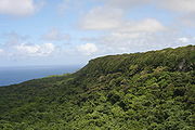
Eua is a hilly island, the highest peaks are the Teemoa (chicken manure) 312 m, with the grave of the soldier on top, and the Vaiangina (watersprings) 305 m. The island is not volcanic, but was shaped by the rubbing of the Tonga plate against the Pacific plate, pushing Eua up and leaving the 7 km deep Tonga trench on the bottom of the ocean, a short distance towards the east. The soil of Eua is volcanic, as is that of Tongatapu, but only the top layer, deposited by eruptions of nearby volcanoes ten thousands years ago. Under it are the solid rocks of pushed-up coral. Eua counts many huge caves and holes, not all of which have yet been explored.Eua is the only island in Tonga that has a river, and had the only bridge in the kingdom until Vavau
Vava'u
Vavau is an island chain of one large island and 40 smaller ones in Tonga. According to tradition Maui fished both Tongatapu and Vavau but put a little more effort into the former. Vavau rises 204 meters above sea level...
also built one. The river drains into the harbour near the capital of the island, Ohonua.
A unique feature is the shore between Ohonua and Tufuvai. It is coral reef still close to the sea level. Many small tidal pools are found, named the otumatafena.
Myths
Together with Ata'Ata
Ata is a small, rocky island in the far south of the Tonga archipelago, situated on . It is also known as Pylstaart island. It should not be confused with Atā, which is an uninhabited, low coral island in the string of small atolls along the Piha passage along the northside of Tongatapu, nor should...
, Eua was the first island to be created by Tangaloa, see Tangaloa And The Story Of How ‘Eua Island Was Created.
History
Eua was put on the European maps by Abel TasmanAbel Tasman
Abel Janszoon Tasman was a Dutch seafarer, explorer, and merchant, best known for his voyages of 1642 and 1644 in the service of the VOC . His was the first known European expedition to reach the islands of Van Diemen's Land and New Zealand and to sight the Fiji islands...
who reached it and Tongatapu
Tongatapu
Tongatapu is the main island of the Kingdom of Tonga and the location of its capital Nukualofa. It is located in Tonga's southern island group, to which it gives its name, and is the country's most populous island, with approximately 71,260 residents , 70.5% of the national population...
on 21 January 1643. He called it Middelburg Island, after the Dutch province of Zeeland
Zeeland
Zeeland , also called Zealand in English, is the westernmost province of the Netherlands. The province, located in the south-west of the country, consists of a number of islands and a strip bordering Belgium. Its capital is Middelburg. With a population of about 380,000, its area is about...
. He did not go on land, but proceeded to the Hihifo district of Tongatapu, which he named Amsterdam Island after the capital of the Netherlands
Netherlands
The Netherlands is a constituent country of the Kingdom of the Netherlands, located mainly in North-West Europe and with several islands in the Caribbean. Mainland Netherlands borders the North Sea to the north and west, Belgium to the south, and Germany to the east, and shares maritime borders...
.
Demography
The villages of the original inhabitants of Eua are all in the north HoumaHouma
Houma can refer to:*Houma, Louisiana, city in the United States*Houma, Shanxi, city in China*Houma Tribe, a Native American group*Houma, a proper name*Houma, meaning cape, the name of some capes in Tonga and villages near them such as:...
, Taanga, Ohonua, Pangai
Pangai
Pangai is the administrative capital village of the Haapai Group in Tonga.-The Town:The village is on the western shore of Lifuka and has about 2,000 inhabitants ....
, Tufuvai.
Haatua and Kolomaile are from the original inhabitants from Ata, who were resettled there in 1863. The villages just north of that up to Angahā, are from the inhabitants of Niuafoou
Niuafo'ou
Niuafoou is the most northerly island in the kingdom of Tonga. It is a volcanic rim island of 15 km² and with a population of 650 in 2006.-Geography:...
who were resettled there in 1946.